


Department for Sustainable
Amazon Cooperation Treaty
Development
Organization
Global Environment
United Nations Environment
Organization of American States
Fund
Program
INTEGRATED AND SUSTAINABLE MANAGEMENT OF
TRANSBOUNDARY WATER RESOURCES IN THE AMAZON
RIVER BASIN
GEF AMAZONAS PROJECT - ACTO/GEF/UNEP/OAS
Bolivia, Brazil, Colombia, Ecuador, Guyana, Peru, Suriname, Venezuela
Activity 1.1 Vision for the Basin and Transboundary Diagnostic Analysis
Final Report
NATIONAL VISION DOCUMENT
Hydrometeorological Service, Ministry of Agriculture
Georgetown - Cooperative Republic of Guyana
INTEGRATED AND SUSTAINABLE MANAGEMENT OF
TRANSBOUNDARY WATER RESOURCES IN THE AMAZON
RIVER BASIN
ACTO/GEF/UNEP/OAS
Activity 1.1 Vision for the Basin and Transboundary Diagnostic Analysis
Final Report
NATIONAL VISION DOCUMENT
Coordinated by:
Hydrometeorological Service
Ministry of Agriculture
Consultant
Anthony R. Cummings
Contract CPR/OAS no. 97084
November 2006
EXECUTIVE SUMMARY
INTRODUCTION: VISION AND OBJECTIVES
The Amazon Cooperation Treaty Organisation (ACTO) was established in 1978 by the
Governments of Bolivia, Brazil, Colombia, Ecuador, Guyana, Peru, Suriname and
Venezuela. Its goal was
people, and in 2004, a strategic plan for the years 2004-2012 was published. The plan defines
a number of areas or themes for development; including the sustainable management of the
region s water and soil resources.
The project Integrated and Sustainable Management of Transboundary Water Resources in
the Amazon River Basin was prepared by the countries that are signatories to the Amazon
Cooperation Treaty (ACTO): Bolivia, Brazil, Colombia, Ecuador, Guyana, Peru, Suriname,
and Venezuela. The goal of this project was to strengthen the institutional framework for
planning and executing, in a coordinated and coherent manner, activities for the protection
and sustainable management of the land and water resources of the Amazon River Basin. The
proposed project endeavoured to realize a shared vision for sustainable development in the
region, based upon the protection and integrated management of transboundary water
resources and its adaptation to climate changes. This will clearly be a long-term effort.
The development of an institutional structure for the coordinated management of the Amazon
region is recent and still fragile. The challenge, in terms of its hemispheric scale and the
number of countries sharing responsibility is great. All eight are developing countries, and
their economic and technical capacities have evolved in very different ways, both in terms of
scale as well as related institutional and legal frameworks.
Accordingly, the project is proposed to be divided into three four-year phases: the first for
planning and development of institutional capacity; the second for implementation of jointly
identified strategic activities; and the third for strengthening sustainable and integrated water
resources management in the Basin, recognizing the likely impacts forecasted to arise as a
consequence of ongoing changes to the global circulation and climatic regimes.
The current Project Development Facility - PDF Block B - is the preparatory phase of GEF
Amazonas Project - OTCA/PNUMA/OEA, which must be executed over a period of 23
months (October 2005 to September 2007). It aims to prepare the full-sized Project Brief,
where its components will be described in greater detail and a shared strategic vision for the
sustainable development in the Amazon River Basin will be advanced, along with the
institutional arrangements and partnerships for the subsequent execution of the project
activities. The Project Brief will not only serve as a guideline for a new GEF grant request,
but will also promote parallel actions in the basin countries and other stakeholders so as to
strengthen the Basin Vision and its program of integrated resource management, including
the adaptation to ecological and hydrological changes caused by global climate change.
i
In Guyana, the Hydrometeorological Service, Ministry of Agriculture has been given the
mandate of coordinating efforts aimed at
water resources are affected by a number of other interest groups and activities, whose views
must be taken into consid
Given the existence of a number of agencies and social actors with mandates and activities
summarise these factors of interest. In particular, this paper attempts to summarise the
institutional arrangements and plans currently in place in Guyana for the management of its
part of the Amazon. Specific emphasis is placed on the key institutions, legal frameworks,
and the
and water resources. Existing plans for water management and use and the impacts of these
on the environment and society as well as the impact of climate change and the socio-
economic conditions are also examined.
The Consensual Vision for the Basin will be defined based on the analysis of the current
situation, as well as on the prognostics of future scenarios. The results of this effort would be
used to guide the definition of the Consensual Vision for the Amazon Basin. It is hoped that
these efforts would partially assist in the identification of issues of transboundary interest in
the Transboundary Diagnostic Analysis DAT of the Basin as a whole. As such, this paper
1.0 CURRENT STATUS
Guyana is the only English speaking country on South America, and is located on South
s to its west and Suriname on its
east. Guyana has an area of 214,970 km2 of which nearly seventy-five percent is covered
with natural vegetation. Physically, Guyana can be divided into four natural regions: (1) the
Coastal Plain or a flat coastal belt; (2) a sand belt; (3) an undulating, Central Peneplain; and
(4) a Highlands region.
1.1.
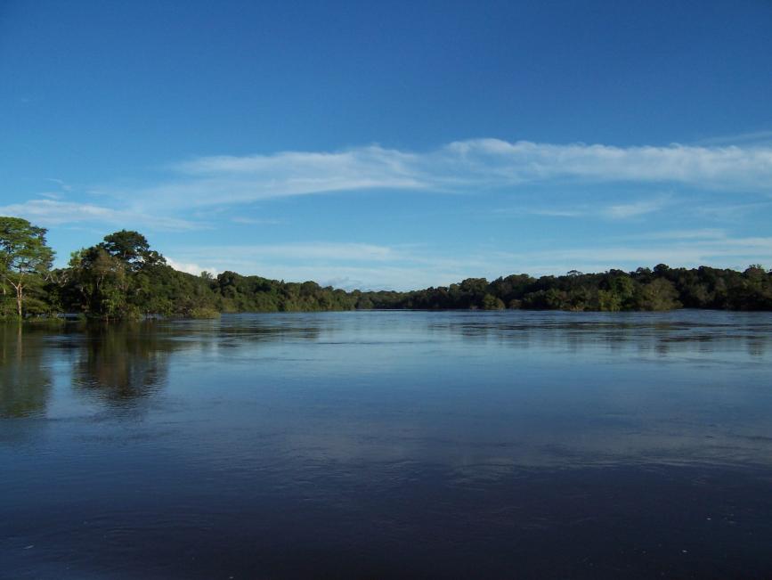
The Basin of the Amazon River and its Sub-Basins
Guyana gets its name from the Amerindian word that translates to land of many waters . As
the name suggests, there is a complex system of rivers, creeks, lakes, waterfalls and other
see Figure 1).
1.1.1.
Mazaruni, Cuyuni, Potaro, Siparuni and Rupununi; the Corentyne, and its tributary the New
River; the Berbice, and its tributary the Canje; the Waini, and its principal tributaries the
Barama, Imotai and Arawapai; the Barima, and its principal tributaries the Aruka, Kaituma,
Anabisi, Whanamaparu and Whanna; the Demerara river; and the Amacura river. Besides
these main rivers, there are the Takutu River and its tributary the Ireng which form the south-
western limits of the country. The Takutu flows into the Rio Branco, a tributary flowing into
the Rio Negro which is a confluent of the Amazon River.
ii
1.1.2. Hydrology
Guyana is one of eight countries sharing the Amazon Basin. Its main river, the Essequibo is
one of the principal rivers of South America with a mean flow of 2100cu.m/s. In fact, the
Essequibo is the largest river flowing into the Amazon between the Orinoco and Amazon
rivers. Much of the
interland area is drained directly or by major tributaries of the
Essequibo and fresh surface water is generally in plentiful supply for most of the year.
Even though Guyana is rich in water resources, most of the surface water and some of the
groundwater requires treatment to make it potable. Most surface water is liable to
contamination and many surface sources would disappear in the dry season.
Interior Plains Area
The White Sands Formation, located in the northern Interior Plains region and in the southern
Coastal Lowlands region, yields moderate to large quantities of fresh water from depths of
less than 30m. This formation is centered in Linden (Region 10 Guyana) and also provides
the origin of the groundwater percolating into the A and B sands aquifers used in Coastal
areas. In the north-western coastal area region, large quantities of brackish to saline water are
available for abstraction at depths ranging from 3 to 30m.
Southern Plains and Western Highlands
Groundwater is generally plentiful from sedimentary and volcanic deposits in the southern
and western regions of Guyana. There is a paucity of potable groundwater in the central
mountainous area of the Hinterland known as the Guyana Shield where only fractures and
small perched discontinuous aquifers produce water. The depth to the water table ranges
from 3 to 300m depending on the location of the well or borehole and levels may also vary
with the season.
1.1.3 Geology
Guyana lies within the Amazonian Craton, which forms part of the South American
Continent (Brazil, Bolivia, French Guiana, Guyana, Suriname and Venezuela). The Amazon
Craton is subdivided into two geographic shields, the Guiana Shield in the North (in which
Guyana is situated) and the Central Brazil (Guapore) Shield in the south.
1.1.4
The 2002 Population and Housing Census showed that the population of Guyana rose to
751,223 persons higher than the 1991 census by a little more than 27,500 persons. This
new count was in keeping with trends of population change for Guyana, which has shown an
increase at each census; except for the 1991 census when for the first time in history the
count was lower than that of the previous census.
1.2 Existing Plans and Programmes
1.2.1 Water Resource Plans and Climate Change Assessment
The Guyana Water Incorporated is currently preparing its Strategic Plan which should
include data on the water supply a
and hinterland
iii
areas. The Water and Sewerage Act 2002, sets up the central legal framework for the
management of water resources in Guyana.
1.2.2. Coastal Agricultural Water Supply
Water for supporting coastal agriculture
ighland region. There is
a complex drainage and irrigation network encapsulating three water conservancies
established to capture, store and distribute rainfall water from
Coastal Guyana. These conservancies are relatively shallow but extensive reservoirs covering
several hundred square miles. This system is monitored by the National Drainage and
Irrigation Authority.
1.2.3. Water and Climate Management and Monitoring
The Hydrometeorological Service, Ministry of Agriculture operates the National
Meteorological Station Network (NMSN) and the National Hydrological Station Network
(NHSN).
By collecting, processing, archiving, retrieving and analysing the data from both Networks,
Hydromet is able to provide information to those agencies that are planning and designing
also analyses the lower and upper atmospheric weather data of the western hemisphere, and
disseminates the information to the aviation and other sectors. The department maintains
several databases with pertinent data on hydrology and meteorology, including the CLICOM
database that is used for precipitation and meteorological data and HYDATA which is used
for archiving streamflow data.
Recent Climate Studies
Guyana has ratified the United Nations Framework Convention on Climate Change
(UNFCCC). To achieve the objectives and meet its commitments of the UNFCC, a Climate
Change Action Plan was developed in 2002. The Action Plan recognised that it was
imperative that climate change activities be developed to ensure that Guyanese were prepared
to deal with the impacts of the consequences of global warming (Climate Change Action
Plan, 2002).
Prior to the preparation of the Action Plan, Persaud and Persaud (1995) classified the rainfall
regions of Guyana. Additional attempts at understanding
conditions were made by Mott MacDonald (2004) and Seulall (2005)
Climate Change Impacts
The possible impacts of climate change in Guyana were discussed in the Initial National
Communication (2001) and some of these are summarized here. The impact of climate
change on water supply is not very clear. Deceasing rainfall and increasing evaporation can
lead to lower water levels in the rivers. Extreme rainstorm events can allow for flood
conditions especially during cold phase ENSO events. Sea level rise can result in salt water
intrusions further up river. Ground water can also be vulnerable to this effect. Demand for
water is expected to increase with increasing temperatures and the relative value of water for
alternative uses would likely change as priorities are determined on the basis or urgency of
needs.
iv
The energy sector will also be affected. Demands for interior space cooling and possibly
decreased hydro-generating potential supply from some river basins can pose some problems.
In the ag
These losses may be triggered by increased water demands from crop transpiration and
greater respiration losses as a consequence of higher temperatures.
A CO2 induced climate change can impact on the forestry sector in a similar way to that for
agriculture. There would however, be a need to consider the impact of increased CO2
fertilization on forest growth. If the dry seasons get drier, then this may impose severe
constraints on forest growth and may be critical in determining species response. With a
doubling CO2 concentration, indications are that the forests in southern Guyana may be
affected with the shrub savannah spreading southward to replace tall evergreen forest. With a
tripling CO2 concentration, the same areas can be affected. However, the northwest may also
be affected by a change to shrub savannah types. Again, the sensitivity analysis must be
guided by further studies.
The Coastal Zone is identified as being the most vulnerable part of Guyana because sea level
rise will be expected to add to the direct impacts of temperature rise, rainfall decrease and
evaporation increase. It is also the part of Guyana where adverse impacts will directly affect
a large percentage of the Guyanese population.
1.3 Other Relevant Plans and Programmes
vision for sustainably managing its part of the Amazon Basin would be built upon
some past initiatives, including:
1.3.1. National Development Plans
Two key documents were produced recently that focused primarily on national development.
The first is the National Development Strategy (NDS) produced in 2000 and which presented
a policy framework for Guyana on critical areas of development, namely: Governance;
Macro-economic strategy and the Management of the Economy; The Environment;
Information Technology; Energy; Transport; Sugar; Rice; Agricultural Institutions; Non-
Traditional Agriculture; Fisheries; Forestry; Water; Mining; Manufacturing; Education;
Health; Tourism; Urban Development; Land; Housing; Amerindians; Gender Issues; The
Family and Its most Vulnerable Members; Labour and Employment; The Private Sector; and
Poverty Eradication.
The second document the Poverty Reduction Strategy Paper (PRSP) in 2005. The PRSP, like
the NDS focused on a number of areas that needed addressing in order to reduce national
poverty including water Resource Management Plans.
1.3.2. Resource Management Plans
1.3.2.1.
National Protected Areas System
There are at least five (5) sites in Guyana that has been earmarked for protected area status:
The Kanuku Mountains, Mount Roraima, Orinduik Falls, Shell Beach, and South-Eastern
Forest. Once instituted, these sites would join the Kaieteur National Park and the Iwokrama
v
International Centre for Rainforest Conservation and Development on the list of national
protected areas.
1.3.2.2.
Natural Resource Management on Amerindian Lands
Amerindian communities that hold legal title to their lands, by virtue of their ownership of
these lands have jurisdiction over all natural resources, with the limited exception of sub-
surface resources and waterways. In recognition of the fact that they have control over these
resources, the Village Councils have been charged under the Amerindian Act 2006 to put
systems in place for the management of their natural resources. During 2005, sixteen
communities in the North Rupununi of Guyana have initiated efforts aimed at formally
managing their natural resources. These efforts attempt to institute management systems on
Amerindian lands that are parallel to those existing on state lands adjacent to their
communities and brining sustainable benefits to their people
-
Laws for the Management of Natural Resources by the Communities of the North
.
1.3.2.3.
The Rupununi Wetlands Project
The Rupununi Wetlands, just southeast of the Iwokrama Forest, includes the Rupununi,
Rewa, and Essequibo Rivers, and many other smaller rivers, creeks and ponds. These
wetlands contain high habitat diversity and support a vast array of wildlife. Through the
collaborative efforts of the Darwin Initiative for the Survival of Species, Iwokrama, the
University of Guyana, the Environmental Protection Agency and the North Rupununi District
Development Board (NRDDB), the monitoring programme aims to develop a better
understanding of the impacts of different land uses on the wetlands.
1.3.2.4.
Hydropower Development
The Hydro-Electric Power Act 1956 provides the legal framework for the development of
hydroelectric power generation in Guyana. A number of sites have been identified for the
development of hydropower facilities in Guyana, of significant note are: Amalai in Region 7
where a 2000 Mega Watts (MW) facility is being explored, Marshall Falls in Region 7 (1100
MW) and Tumutumari (35 MW).
1.3.3. Soils and the Environment
The National Agricultural Research Institute (NARI) is currently spearheading research on
soil and land use surveys, management of aquatic weeds and soil management. NARI also
holds maps on soil types and structure throughout Guyana.
1.4. Biodiversity and Forests
1.4.1. Biodiversity
Guyana has remarkable diverse habitats and a rich flora (plant life) and fauna (animal life)
which remains largely unexplored. It is unique in the world because the majority of its
natural resources remain in a pristine state. While Guyana is one of the smaller countries of
the wider Amazon region, it contributes significantly to the biodiversity, both in terms of
number of species and number of endemics. Its natural ecosystems are relatively intact due
mainly to low population pressure and to limited commercial activity. Guyana recently
prepared a National Biodiversity Plan, which seeks to promote conservation and sustainable
vi
1.4.2. Forests and Forestry
The Forest Resources
The forest of Guyana covers some 16.45 million hectares or 75% of the total land area. Of
this area only about half (8.7 million hectares) is considered accessible for economic
exploitation. This forest is generally considered tropical moist evergreen rainforest, though
represented by various forest types. The permanent State Forest Estate, which covers some
13.58 million hectares, is administrated by the Guyana Forestry Commission (GFC). The
remaining forest areas are Private Property, Amerindian Community Titled Area or State
Lands administered by the Guyana Lands and Surveys Commission.
ts
Rain Forests
Rain forests occur in areas where the climate is wet, with rain occurring every month or
where dry spells are short. Trees are numerous and stand in strata or layers, ranging from low
shrubs to very tall dominant trees with large spreading crowns. Climbers and epiphytes
are abundant. In Guyana, rain forests are the most common forest type, occurring from the
north-west through to the south of the country. It is also the most important type for timber
production.
Dry Forests
Dry forests occur where soil moisture is frequently limited either because the soil drains
rapidly or where there is excessive evaporation due to strong winds. Examples of dry forest
are found on the white sands of the Soesdyke-Linden highway and throughout the Pakaraima
Mountains. Wallaba forests are common in the white sand regions.
Seasonal Forests
Swamp forests occur where drainage is impeded and soils are frequently waterlogged. This
forest type includes the mangrove forest along the coastline and the Mora forests occurring in
lowland swampy areas and along the interior. Mangrove forests provide protection to the
shoreline against erosion and are an important habitat for marine life.
2.0. DYNAMICS OF CHANGE
It is well documented that the world freshwater resources are under threat from human
development and anthropogenic activities and changes in global climate conditions. Due to
future. However, number of driving forces have been identified as driving forces behind
global change.
2.1. Driving Forces of Change
There are a number of areas that have been identified as the major drivers propelling the
global water scenarios: demographic this includes population growth, migration pressures
and urbanization; economic economic outputs; trade; prosperity; water works investment;
technological hi-tech expansion; water efficiency; unit water pollution; adoption of new
crops; water sanitation investment; number of desalinization plants; withdrawal efficiency;
vii
social lifestyles, poverty, inequity; governance power structure ; level of conflict;
globalization; environmental water related diseases; soil salinity; groundwater; and
ecosystem health.
Many of these driving forces are visible in Guyana and indeed the wider Amazon Basin, and
therefore would need to be considered when shaping the scenarios for future management of
in order to observe if some of these
driving forces are active in this part of the Basin.
2.2 Future Scenarios
2.2.1 Overview
resources would be built on the
current situation. Future management strategies would be built upon the visions and
programmes from the institutions and social actors whose mandates directly affect the
es took the
opportunity presented by the National Vision workshop to share their current programmes
and plans for the future, this allowing for plausible outcomes for the future sustainable
, with specific emphasis on water to be
determined. The positions of the individual agencies were consolidated to arrive at a national
position for the short, medium and long term.
It should be noted however, that even though special emphasis was placed on water,
participants at the National Vision workshop engaged their energies on the various themes of
sustainable development. The following section presents a summary of the scenarios
developed at the National Vision workshop.
These scenarios are not to be used solely to estimate future supply and demand needs, but
they should provide a starting point for evaluating various management options including,
but not limited to:
1. Moderating water demand through demand management programs, changes in water
prices, and efficiency programs and;
2. Increasing water supplies through urban water re-use facilities ground water reclamation,
recharge, and conjunctive use, increased water storage and conveyance, and
desalinization.
These scenarios presented below are written with the understanding that they are only likely
futures and not forecasts, as clearly it would be impossible to forest cast how water
management would evolve in the future.
2.2.2 Short term: 5-Year Scenarios
In the short term, it is expected that much of the current trends aimed at improving
environmental management and the development of the national population of Guyana would
continue.
viii
The current policy aimed at improving the Water Sector with respect to the delivery of
potable water to a wider cross-section of the Guyanese population would also continue. This
would include changes in the system for water delivery with the likely implementation of
more efficient systems of delivery, with customers being required to pay for potable water
and off-setting production cost. This would be especially applicable to the Coastal plain and
particularly in the vicinity of the capital city of Georgetown.
In the short term, it is likely
being utilized for environmental purposes would be directed towards agricultural and
industrial activities (agricultural and urban water use) as these areas are developed.
The National Water Council is expected to begin functioning as mandated in the Water and
Sewerage Act 2000, with the National Water Policy (NWP) being developed and
implemented accordingly. The implementation of the Act would result in a greater role by
the key agencies as stipulated by the legislation.
The Water and Sewerage Act (2000) has been developed to allow for a concerted effort at
monitoring climatic and other factors that may impact upon this resource. At the moment,
however, the Act is not being implemented to its full force, thereby not allowing for many of
its credible intentions to be achieved. In the short term, it is likely that there would be more
effective implementation of the Act allowing for greater protection and sustainable utilisation
of water resources in the Guyana. It is likely too that at the regional level, efforts would be
made to harmonise water use legislation and management systems.
2.2.3 Medium-term: 10-Year Scenarios
From the discussions at the National Vision workshop, it appeared likely that in 10 years
time Guyana would be aiming towards a resource use regime that is less resource intensive,
and more focused on improving the efficiency in which natural resources are utilised.
be taken towards
ecosystem purposes. In the Forestry Sector, for instance, it is likely that all activities would
be made to stringently adhere to instruments such as the Forest Code of Practice. Other
forest use protocols would be adhered to - ensuring that waterways in the forests are
protected and vegetation in catchment areas are not destroyed. More efforts would be made
to ensure that forest and non-timber forest products are carefully utilised, with greater efforts
for value added processing of timber products in order to bring lasting benefits to the
Guyanese people and thus making a sound contribution to the global carbon equilibrium.
The demand for water would grow, making it necessary for investments in establishing more
efficient systems for water delivery and potable water processing. This would, however, tend
to result in improved equity, efficiency and sustainability of the Water Sector. It should be
noted that the current trends in the Water Sector do strongly suggest that this is the direction
in which the Water Sector is likely to move.
ix
As the Water Sector expands, there would be higher prices and possibly increased investment
in the Water Sector. These new developments would encourage the private sector to invest in
research and development of the Water Sector. This renewed interest in research could result
in greater involvement of research institutions such as the University of Guyana and make
the role of the Hydrometeorological Service more critical in this era.
Ground water aquifers and coastal water supply would be areas that would receive increased
research and interest as well. The current assessment of sea level rise and implications for
Guy
It is also being suggested that
. This could have the likely
impact of coastal aquifers being infiltrated by saline water from the Atlantic Ocean. Such
impacts may become more pronounced in the medium term, giving even more importance to
the role of the Hydrometeorological Services.
Changes in global climate and sea level rise would more than likely demand that greater
attention be placed on improved water management and water productivity. For example, the
Agricultural Sector would be affected and there would even be a need for developing new
crops and examining the option of moving cultivation from coastal to inland Guyana. The
introduction of new crops into areas that are currently covered in other vegetation types
would mean that there is a shift in water use and demand. New crops would also require
irrigation - removing water that would have previously been used for environmental purposes
to agricultural areas. The movement of cultivation from coastal to inland Guyana would also
require that new water storage areas be established inland as agriculture would demand that
water storage facilities be in place to sustain economically viable crop production.
At the same time, the increasing population and the impact of current programmes aimed at
improving the livelihood of Guyana population would probably result in an increased
demand for water. More of the population would require water for basic life functions, and
the creation of new wealth could result in persons using more water for increased domestic
comforts - for instance, swimming pools and Jacuzzis. Even though absolute poverty may be
reduced, income inequalities may increase, and at the detriment of the environment.
The changing situation would require that the Water and Sewerage Act 2002 be fully
implemented
fact, it is likely that during this era the interconnectivity of all natural resources would be
fully appreciated and management efforts would therefore aim to develop an integrated
approach towards management. For instance, the Hydromet Service recognises that it would
need to be strengthened with specific emphasis on: modernization and institutional
development, expansion of monitoring network, and the hiring of more trained staff. There
would be a need for co-operation/partnership between various organizations such as
academia, Gover
and so on; better decisions
based on more complete and accurate weather, water and climate information; partnerships to
provide better data coverage and information processing; higher resolution models and more
precise and useful specialized products.
The foregoing suggests that there would be a dire need for the old paradigm of all natural
resource extraction and monitoring occupying specific niches would be removed and all
x
would operate with an integrated agenda
water and natural resources.
In the Mining Sector, it is expected that more systematic exploration and mine planning
would be done by Medium Scale Miners. It is likely that there would be a greater mix of
Large, Medium and Small Scale Operations and a diversification in minerals exploited.
Improvements in the Mining Sector and increased investment are likely to result in
downstream value-added products such as alumina being produced. With greater efficiency
nvironmental practices are likely to improve, including reclamation and
compliance with regulations. At some point in the medium term, as well, it is likely that
Guyana Geology and Mines Commission (GGMC) would be able to decide how many Small
and Medium Scale Operations would be allowed in an area. Further, it is likely that this era
would see a greater appreciation for ecosystem functioning leading to more environmentally
friendly mining. The sector may subscribe to the concept of Landscape Forest Management
that positively addresses mining.
So whilst the short term is likely to see continued conflict between resource extraction
activities such as forestry versus conservation, the medium term is likely to see some of these
issues clarified at the national policy level.
2.2.4 Long-term: 20-Year Scenarios
In the long term, it is very likely that the national population would increase, and the current
programmes to increase agricultural and industrial production would be bearing fruit.
However, increased population would also mean that there would be a greater demand on the
natural resources of the country. The current initiatives to improve environmental
management would also be bearing their rewards and there would be greater environmental
awareness by the population.
A better educated and informed population would be aiming to achieve more sustainable
values and lifestyles. The current institutions for the management of natural resources, in
particular water would probably become more open and focus more of their energies on
fact demand that their views are fully incorporated into the decision making process.
It is likely that many of these actions would emanate at the community-level, driving action
towards sustainable watershed management, rainwater harvesting and focusing on increasing
mean-yield levels in irrigated and rainfed areas. Decision-making in the Water Sector is
likely to be more transparent, involving all stakeholders. If this trend should prevail then it
would become likely that ecological functions are recognized and maintained with human
water use becoming sustainable.
It is during this era too that the current predictions on climate change and its impact would
become noticeable in Guyana. The national population is likely to be more aware of weather
related issues and take appropriate action in response to warnings. The increased demand for
quality data to safeguard human well-being would probably determine that numerical
prediction models for both hydrology and meteorology be developed along with more
Hydrometeorological stations being set up across the country, with responsibility for
xi
hydrological and meteorological programmes. If the impacts of global climate change and
sea level rise begin to take effect then there would be a need for research on ground water
resources of the coastal artesian basin.
In keeping with the likely increased education and awareness of the national population, it is
likely that the population would request more information geological, water quality,
biological, watershed and related databases, GIS etc. would lead to better management of
mineral resources. It is likely too that the mining industry would become more diversified,
and more miners would want to comply with regulations since they would then recognise the
benefits.
Similarly, it is likely that operations in the forestry sector would pay great attention to
environmental concerns and more operators in the sector would take action to ensure that
their activities are having minimal impacts on the natural environment. The increased
concern for the environment would require that there be more effective collaboration
between Agencies and Sectors. There is likely to be greater effective participation in mining-
friendly Landscape Forest Management. At this point too it is likely that capacity would be
built for environmentally friendly mining and monitoring by GGMC, EPA, Miners and
Communities.
Conclusions
These scenarios are plausible futures, not forecasts. They are differentiated by important
assumptions about uncertainties in water and other resource conditions. Materially different
future conditions can significantly affect the nature and outcome of various mixes of
management strategies. Some management strategies may be effective and economical
regardless of the future scenario. Other strategies may only be suited if specific conditions
develop in the future.
Developing quantitative estimates of water demands and supplies for multiple future
scenarios and management responses require using available data and assumed relationships.
For Guyana, and the wider Amazon, we need to consider the current situation and the way
the various stakeholders with direct impacts on water resources would like to design their
various programmes. After all of these factors are taken into consideration, we can develop
resource and as an extension, the Amazon region for the short, medium and long term.
indeed, the regional position must take into account the existing situation is each of the eight
countries that are signatory to the Amazon Cooperation Treaty. This is so since the existing
reality in each of the countries would have to be taken into consideration when shaping a
regional position. this prospect would be extremely challenging, as no two countries would
have the identical realities.
xii
RELEVANT TRANSBOUNDARY ISSUES
3.1 Transboundary Issues and Identification of Hot Spots of Common Interest
3.1.1. Transboundary Issues
The following issues were identified as significant and relevant transboundary issues (in
order of priority):
1. Global Climate Change
Global climate change has been identified as one of the most important issues that would
confront the eight states of ACTO in the medium to long term. Climate change would impact
One of
the impacts of climate change and sea level rise would be the intrusion into freshwater and
coastal aquifers of saline water into coastal states such as Guyana and Suriname. This would
have definite impacts on coastal existence and would lead to changes of the lifestyle in this
part of the country.
Currently, approximately 90% of the Guyanese population occupy the Coastal Plain region.
The impacts of climate change could force the Guyanese authorities to consider relocating
the population inland to occupy the highland regions of the country.
coastal population be forced to move as a result of climate change, this movement would
impact directly on the forested catchment areas of the country, probably leading to
deforestation as population movements in land would require new settlement to be developed
with their associated services.
2. Population Growth/Transient Population
supply. An increase in the human population of Guyana would translate to more persons in
need for freshwater and greater demand for quality freshwater. Transient population would
are known to be transient. The movement of people from one county to another could
translate to the movement of attitudes towards water use and protection for the aquatic
environment from one jurisdiction to another.
3. Health
Water borne diseases especially in the hinterland areas of Guyana could become a problem as
the region faces climate change. Change in climatic conditions would create conditions that
may predispose vectors of water borne diseases to proliferate. This could lead to an increase
in flood related diseases, and diseases related with general sanitation.
4. Sedimentation and Pollution
Anthropogenic activities such as agriculture, mining, forestry, housing development, and
tourism could have the likely impact of land degradation. When land is degraded it is easily
eroded and could find itself into waterways. These sediments (and other pollutants) could
then affect the aquatic life present in the watercourses.
soils that are easily eroded once the forest cover is removed. The conversion of such land for
agricultural purposes, in the absence of the most appropriate land management practices
xiii
would also lead to the loss of soil resources. Activities in the Mining, Forestry and
agricultural sector lead to pollution of the countr
and watershed
management.
5. Deforestation
The removal of forests in forestry and mining activities, and failure to replant same, would in
the long term have an impact on the carbon sink potential of the country forests and rainfall
catchment areas.
6. Water Resources Use
GWI in its drive to bring potable water to a broad cross-section of the Guyanese population
would need investment in water sanitation, water treatment facilities and improvements in
water distribution systems to meet the needs of its customers. These investments would
immediately affect the nature of water use and distribution in the country, increasing the cost
of water delivery. Hydropower generation is receiving a great amount of national attention at
the moment. These new developments would bring a new demand on the countries water
resources, with water that is normally used for environmental purposes being transferred
elsewhere.
7. Illegal activities including: fishing, wildlife, intellectual property rights
Some species of fish and wildlife, example Arapaima gigas moves freely between the
Guyanese and Brazilian borders. The species is endangered in both countries, with regulation
enforcement believed to be stricter in Brazil than Guyana. As a direct consequence, Brazilian
claiming that fish populations are decreasing.
8. Energy
The ever increasing price for fossil fuels on the global market place would affect all the
countries party to ACTO. There is therefore a need for the development of alternative
sources of energy. Hydropower is a very likely source of this new energy and is certainly
being pursued by some states, however, this source of energy also have environmental
impacts.
9. Navigation
The rivers of the Amazon Basin serve as a significant navigation route. The movement of
people and goods and services throughout the region has significant benefits as it can
improve trade within the region. Free movement can, however, have negative impacts if not
properly managed as this could allow for the movement of illegal materials. Indiscriminate
movement of vessels within the rivers of the Basin could have the greatest impact, however,
10. Investigate transboundary off-site effects
Many parts of the Amazon Basin region are interconnected although hydrology is not the
means by which the region is connected. This would suggest that there is a chance that the
countries could be sharing the same sources for water table, water cycle and spawning areas
for aquatic species. Given that ecosystems may be contiguous and similar there is a good
xiv
chance that activities in one part of the region would affect another part. This is of particular
concern and would require some more investigation.
3.1.2 Hot Spots
A number of biodiversity hotspots have been identified by Guyana for future management.
Most of the areas highlighted here have been earmarked by the Government of Guyana for
protected area status in the future given their high biodiversity importance. The sites that
have been earmarked for protected area status are shown in Figure 18, whilst descriptions are
given below.
The following hot spots were identified:
Kanuku Mountains
Mount Roraima
Shell Beach
South-Eastern Forest
Kaieteur National Park
Rupununi Wetlands
Amerindian Communities
3.2. Thematic Axes and Priority Themes for the Amazon Basin
At the national vision workshop, the following areas were identified as being critical for
collaborative efforts between the countries signatory to ACTO. The following list have been
prioritized for consideration.
3.2.1 Hydrometeorological Monitoring and Institutional Strengthening
Monitoring of hydrological and meteorological conditions is critical to the sustainable
development of Guyana. The current system for monitoring needs to be strengthened so as to
allow for accurate accounting for changes in national (Guyana) hydrological conditions. The
Hydrometeorological Service has reported that the minimum requirement for operating the
National Hydrological Network is a network comprising of at least seventy (70) stations. At
the moment, Guyana NHN only has around seventeen (17) stations in operation. This system
once operated with a much more comprehensive network of stations located throughout
Guyana, and would certainly need to be restored to a position meeting the minimum
requirements especially in face of global climate change observations.
A fully functional and comprehensive network would allow for comprehensive data
collection. The analysis of such data could lead to the sound decision-making with respect to
the impacts of climate change on the cou
3.2.2 Domestic Water Supply and Demand
With the changes in the Water Sector over the years, water is now being treated as a
commodity and traded like any other commodity on the market and is therefore influenced by
market forces demand and supply.
xv
Big issue is efficiency of supply.
3.2.3 Agricultural Water Supply
As efforts are made to improve agricultural production at the national level drainage and
irrigation would need to be addressed nationwide.
Changes in the agricultural sector would use water that was traditionally used for
environmental purposes to agricultural purposes.
3.2.4. Land Administration and Land Use Planning
Land use planning is probably the most important aspect in drive towards sustainable
development. In light of global
and utilized to bring optimum benefits to the population.
3.2.5. Mining
Despite the positive economic benefits, mining remains and area of conflict and needs careful
management.
3.2.6. Forestry
Similar to mining, activities in the forestry sector are a major threat to the environment
especially catchment areas and biodiversity.
3.2.7. Housing and Development
The current trend along the coast of Guyana is for old sugar cane cultivated areas to be
converted to housing areas. This trend is expected to continue in the near term. This may be
so despite the fact that these areas may not be the most appropriate for housing. The
development of roads to access settlements, forestry and agricultural areas are not necessarily
done in a manner that has the minimal impact on the environment. For instance, roads are
developed and sediments from excavation works would easily find their way into water
courses. This direct sedimentation could result in impacts on aquatic organisms and
ecosystems.
3.2.8. Population Growth
The Housing and Population Census (2002) strongly suggest that the national population is
wth is also being affected by immigration into the
in mining activities.
3.2.9. Research
The focus of research at the University of Guyana is to improve the quality of environmental
management decision making. Particular attention is paid to advancing the uptake of research
information. It is recognised that improved linkages and interactions should be facilitated
xvi
between researchers and end-users, that is, policy and decision-makers. Specifically the areas
of Ichthyology: Fisheries Studies, Inventory, Monitoring, Taxonomy and Secondary
Succession of Aquatic Systems; Water Quality: Parameters, Development and Impacts and
Monitoring and Indicators.
3.2.10. Energy
The current drive in the Energy Sector is to aggressively reduce the dependence on fossil
fuels. It is expected that in the short term greater efforts would be made with respect to the
development of renewable energy sources, including hydropower, solar and wind.
3.3. Priority Areas of Intervention and Actions to Minimize the Main Problems and
Optimize the Potential for Integrated Water Resource Management
In recognition of the issues, and that that they are transboundary in nature, it would be
necessary that in the near future that the countries that comprise ACTO seek to work together
in order to address these and to allow for the sustainable development of the region. Some of
the possible actions that should be considered could include:
1. Maintaining and establishing obligations to international and regional conventions, for
instance, the Convention on Biological Diversity, United Nations Framework Convention
of Climate Change, and the Amazon Cooperation Treaty. Such actions would allow for
greater spatial coverage of areas of concern, allowing for a better understanding of the
driving forces that may be impacting on natural resources and could give rise to
comprehensives measures to deal with the same, and in particular the highly threatened
fresh water resource. The Amazon Basin and the adjacent areas should now, for instance,
be viewed as a single unit in space and treated accordingly. Management strategies
should then be appropriately scaled and geared to allow for the management of the area
as one unit. Such an approach is necessary and even though it would have to take into
consideration the circumstances of the individual countries, is the only sure way to ensure
that the regions resources are meaningfully managed in the face of global climate change.
2. Develop synergies between organisations in addition to Memoranda of Understandings
between agencies at the national and regional level, there is now a need for renewed
efforts of cooperation between agencies with mandates in the natural resource sectors that
would allow these agencies to work closely together and share information. Such efforts
should not only occur at the level of individual countries, but it should also take place at
the regional level. Various protocols for the sharing of efforts and indeed mechanisms for
integrating efforts at natural resource management should be urgently pursued. It should
be recognised that the natural resource sector is strongly interlinked and that each of the
sectors could have impacts of water resources in the region. Once the interconnectivity of
should be relatively easy to justify. The area of Hydrometeorological Monitoring could
be an area for consideration for future collaboration.
3. Build capacity building at all levels to deal with the environmental issues the lack of
properly trained personnel and the supporting infrastructure to deal with environmental
xvii
issues is an area that needs to be addressed urgently. This is particularly the case for
Guyana, which has a very high rate of skilled personnel leaving the country. It is not clear
if this is the case throughout the ACTO region, but the fact that the regions environment
is reportedly threatened is probably a good suggestion that there is shortage of skills
throughout. The quest for sustainable development would require significant investment;
an investment in human resources should take a top priority for future efforts in the
region.
4. Ensure technology transfer/adaptation it is acknowledged that the eight countries that
comprise ACTO are all developing countries. However, each of the countries is at
varying levels of development at the moment and each is attempting to tackle its
environmental issues in its own way. The problem
often not unique to any one state, and it is very possible that some states would have
lessons learnt and experiences in dealing with specific issues from which their neighbours
can benefit. Efforts should be made to understand the problems facing the countries and
attempts be made to see how any one country in the region can benefit from another.
5. Foster harmonization of efforts with respect to resources use and management across
border - there should be similar standards and codes of practices for the use of resources,
both consumptive and non-consumptive, across the region. This area would be affected
by the varying levels of economic development across the region a fact that should be
taken into consideration. However, this should not prevent countries from attempting to
arrive at codes that would at the very minimum allow for the sustainable utilisation of
natural resources. This is particularly urgent as more reports are coming forward on
pressures that are being placed on the resources especially forestry - of the Amazon
Basin as states attempt to increase agricultural output.
4.
INTEGRATED STRATEGIC VISION ON THE WATER USES AND USERS
4.1. Water Use Foreseen in the Amazonas River Basin
There are a number of areas that have been identified as the major drivers propelling the
global water scenarios: demographic this includes population growth, migration pressures
and urbanization; economic economic outputs; trade; prosperity; water works investment;
technological hi-tech expansion; water efficiency; unit water pollution; adoption of new
crops; water sanitation investment; number of desalinization plants; withdrawal efficiency;
social lifestyles, poverty, inequity; governance power structure; level of conflict;
globalization; environmental water related diseases; soil salinity; groundwater; and
ecosystem health.
4.1.2.
can be considered to be providing the following functions or
occupying the following areas of water use.
4.1.2.1.
Urban Users
Urban water demand includes the demand by households/residential, the commercial and
industrial sectors, and the public. In order to accurately define the urban water demand of
Guyana, the demand for each administrative region would need to be computed and the
xviii
resulting sum would represent the entire country. There are a number of factors that must be
taken into consideration when the urban water demand is being computed, including
population (housing growth, employment growth); housing (mean sizes of single family and
multiple family homes, changes in the population living in homes); water use coefficients
(indications of the amount of water demanded by each demand unit). In time water use
coefficients may change in response to factors such as changes in the price of water and in
consumer income, improvements in the efficiency of equipment related to water use, and
active programs designed to accelerate these equipment upgrades; and other demand losses.
4.1.2.2.
Agricultural Uses
Agricultural water use refers to the sum of water used for irrigation purposes, losses, and
other uses. Irrigation water use depends upon the amount of land under irrigation, the
amount of multicropping (planting more than one crop per year on the same land), and the
water use per crop per planting. This area of water use also takes into account the changes in
agricultural land use over time due to (1) conversion of agricultural land to urban uses, (2)
new land becoming irrigated, (3) changes in the amount of multi-cropping, and (4) changes
in the crops being irrigated. Every crop type would tend to have a different water demand
coefficient. This aspect of water use also takes into consideration the evapotranspiration
requirements of the crops referred to as applied water. Evapotranspiration varies by crop
and growing conditions. It may be reduced by improving irrigation methods (by decreasing
non-productive evaporation) and may be increased when yields are increased.
4.1.2.3.
Environmental Water Use
Environmental water use can be classified as the amount of water purposefully permitted to
flow through natural river channels and wetlands that are used for environmental purposes,
instead of being diverted and used for urban or agricultural purposes. In real terms, it does
not necessarily reflect all environmental needs, but attempts to reflect the fact that the various
aspects of the natural environment require water for proper functioning.
In order to define the scenarios for the water uses and users in the short, medium and long
term scenarios, it would be necessary to define the areas of water use and likely changes for
the future time frames. Quantifying these areas of water use would also become important if
be sustainably managed.
4.2. Strong and Weak Points, Opportunities and Threats identified in the Development
of the Environmental Management of the Basin
4.2.1. Strengths for Environmental Management
There are a number of areas that can be identified as strengths for the environmental
management of the Basin. The following are specific to Guyana at this stage:
Legislation- there exists a comprehensive suite of legislation aimed at the sustainable
utilisation and protection of the environment and natural resource base in Guyana. The
Environmental Protection Act, 1996 is the focal point legislation for environmental
protection in Guyana. Similarly, the Water and Sewerage Act 2002, provides the tools for
rces. There is a Town and
xix
Country Planning Act (1948) that provides the mechanism for physical development
planning and land use control. The Lands and Surveys Commission Act (1999); National
Parks Commission Act (1977); National Trust Act (1972); State Lands Act (1903);
Amerindian Act of 2006; Local Government Act (1945); Mining Act (1991) govern and
regulate access to the use of land and associated resources.
o Policy there is a number of instruments in the form of policy documents, strategies and
action plans aimed at supporting legislation. These include the National Development
Strategy, National Land Use Policy, the National Biodiversity Action Plan, National
Environmental Action Plan, National Strategy for the Conservation of Biological
Diversity; National Environmental Education Strategy; National Mangrove
Management Action Plan (2001); Poverty Reduction Strategy Paper (PRSP); Draft
Management Pan for Arapaima in North Rupununi; Draft National Solid Waste Policy;
Shorezone Management Programme (SMP); Integrated Coastal Zone Management
Action Plan (2000); Strategic National Forest Action Plan; National Tourism Policy
Document; Ministry of Housing Ten-Year Development Plan and Guyana Climate
Change Action Plan (2002). These all support legislation aimed at environmental
management and sustainable development.
Desire to achieve Sustainable Environmental Management the fact that all of these
legislations exist is a strong indication that there is a desire for environmental
management in Guyana.
4.2.2. Weaknesses for Environmental Management
Inadequate Enforcement of Legislation as shown in the section on strengths, there
exists a good suite of legislations, but often the real challenge is in enforcing these
legislations or as an extension, implementing legislations to the full extent.
Monitoring Environmental Change this is particularly the case for the
Hydrometeorological sector. The current network is not believed to be adequate to cover
the spatial and temporal changes that may be occurring in the hydrology and climatology
of Guyana.
Human Resource constraint the lack of people to perform functions within critical
departments is a deterrent to achieving environmental management. The example of the
Hydromet comes to mind with its current state of under-staffing.
Availability of Financial Resources it is probably obvious that if the financial resources
were present then it would have been more likely that key vacancies at most of these
agencies would have been filled.
4.2.3. Opportunities for Environmental Management
o Renewable Energy (wind) there is great potential for the development of wind
energy. Once developed, wind energy would allow for pressure to be removed from fossil
fuels resulting in lower energy costs and lower greenhouse gas emissions.
o Hydroelectricity Generation- Guyana has an abundance of water that could allow for the
development of sustainable hydroelectric power.
o Availability of Pristine Forests- there is a large supply of pristine forest that can be
utilised in a number of ways, including, of course, a commodity in emissions trading
agreements.
xx
o Low Population Density the low population density of Guyana can be viewed as a
disadvantage as well as an advantage. It can be viewed as an advantage in this case since
greater planning can be done in many parts of the country without affecting a great
number of people.
o Protected Areas there are only two protected areas in Guyana at the moment. The low
population density leaves a number of areas of high biodiversity value uninhabited,
which in turn, could allow for protected areas to be easily implemented.
4.2.4. Threats for Environmental Management
o Low Coastal Topography
environmental management when it is considered that sea level is currently changing.
Any breach in the coastal defence will result in coastal aquifers and ecosystems being
damaged by saline water.
o Demand for Water Resources - with an increase in industrial activities of agricultural
production and increasing human population, the demand for water resources would be
increased. Even though Guyana is called the land of many waters, a large quantity of the
water available for human consumption requires treatment before it is potable.
o Pollution pollution from solid waste is a concern in Guyana. Irrigation waterways along
the coast are particularly vulnerable to indiscriminate disposal of solid waste. This not
only impacts upon aquatic life in these waterways, but it also hinders the flow of water,
leading to flooding.
o Population Concentration - 90% of population lives in areas
In the
event of a catastrophic event, a large percentage of the population would be vulnerable.
In the long term, the impacts of climate change may begin to affect coastal Guyana.
These impacts may determine that the coastal population be relocated inland. Such an
activity would come with a very high cost.
o Accessibility to Hinterland Areas (high potential capital cost) it is currently very
expensive to access hinterland Guyana. Given the changes in global climate, and the
possibility that the coastal population may be forced to move inland, then this cost could
become a significant hindrance. The current high cost of movement, could also be held
responsible for involvement of hinterland communities in national development efforts.
o Climate Change may adversely affect habitats and thus, faunal assemblages and diversity.
o Lack of Trained Capacity at all levels on biodiversity management.
4.3.
National Vision to the Future
4.3.1. Vision Statement
commits itself unequivocally to pursuing a pattern of development that respects the
integrity of all member states of Amazonia even as it seeks, through integrated approaches
to sustainably use and conserve its natural resources in order to improve the quality of life
xxi
4.3.2.
Vision for the Future
The National Vision workshop has been described as a timely and important event for a
number of reasons. Firstly, it is timely because Guyana must begin to recognise and
capitalize on its unique setting with its intact tropical rainforest, and its abundant water and
other natural resources; Guyana ranks a
th Most Water Rich Country (Water
Poverty Index, UK Centre for Ecology & Hydrology, 2003). As part of the Guiana Shield,
this region contributes 10-
es are increasingly being depleted, whilst it
ha of biocapacity1 space to maintain their lifestyle. If all of us were to live as in Europe, we
need 2.1 Earths. If all of us were to live in the US, we would need nearly 5 Earths. Having an
average of only 2.3 ha per capita available in the EU, the rest of the average footprint of a
Basin where the pressures of population density are not as severe as in most other tropical
rainforest environments.
Thirdly, the National Vision Exercise is timely because of the ongoing work by ACTO in
defining the geographical boundaries of Amazonia (initiated 2004); the process also
coincides with the initiative of the WWF to develop a strategy for natural resource
management of the Guiana Shield.
Fourthly, the National Visioning process is most timely, given the very significant climate
greenhouse gases.
Finally, the National Visioning Exercise is important as it provides a forum by which we can
collectively understand and determine how our resources should be managed and used; it
allows us to learn from the experiences of each other and develop a more holistic approach to
our various mandates; and perhaps most importantly, it further inserts Guyana into the
Amazon Basin a fact that cannot be discounted when one observes the 10-year cycle of
excessive flooding in the Rupununi Region, in which the waters of the River Takutu mingle
with the waters of the Rio Branco.
A National Vision for the Sustainable Management of the Transboundary Water Resources in
the Amazon River Basin must be motivated by the appreciation of the regional and global
context of Guyana, located in the Guiana Shield and as part of the Amazon Basin. The Vision
must also be placed within the context of ongoing national processes, such as the national
land use planning, a new national biodiversity action plan, the Amerindian land titling
process and of course the expansion of our natural resource extraction sector. All of these
circumstances, except perhaps for land titling, while they lead to an increasing global (and
national) value placed on our natural resources, do not necessarily translate into greater value
to people who depend on these resources.
1 Biocapacity is defined as areas of grassland, cropland, forests, fisheries and wetlands
xxii
It is this understanding of where Guyana is situated nationally, regionally and globally, and
in the context of the ecological and social structures that must guide land use planning. We
recognise that this is the first activity of a more substantial process ahead of us.
Following on the models provided by the programmes such as Iwokrama, it is the vision of
Guyana to promote the conservation and sustainable and equitable use of tropical rainforests
in a manner that will lead to lasting ecological, economic benefits to the people of Guyana
and the Amazon Basin through the sharing of knowledge and dissemination of technologies.
development of models for commercially sustainable, practical and community-inclusive
conservation businesses based on tropical forests and their `natural assets, Guyana would
thrive to become a State where all natural resource exploitation activities are kept within the
principles of sustainability.
In the long term, it is hoped that models such as Iwokrama where baseline surveys for
vertebrates, flora, commercial timber and non-timber forest products (NTFPs),
archaeological remains and fungi have been done, would be used to guide the national
sustainable development process. Throughout a decade of survey and inventory of the
environmental assets, Iwokrama has engaged fully with local communities and other
stakeholders in the development of operating frameworks for future business operations,
including reduced impact logging (2000), wildlife management (2001), intellectual property
rights (2001) and development of sustainable and equitable business partnerships (2001,
people-centred with the views of local people being greatly integrated into the national
development process.
Further, it is hoped that decisions for resource extraction and even non-consumptive natural
resource use would be based upon sound understanding of the prevailing environmental
conditions and the impacts of new activities on the environment.
It is clear from the discussions during the National Vision workshop that the current trend of
resource extraction would not bring us the sustainable benefits and development we so much
would like to achieve. The importance of working together, firstly, among ourselves at the
national level in areas of common interest cannot be overemphasized. This point was stressed
over and over again, as the various agencies recognised that in order to attain sustainable
environmental integrity whilst achieving sustainable development.
At the regional Amazon Basin level, the purpose of sustainable development would be
greatly served when the efforts of the individual countries are harmonizing and leading
towards one goal, protecting the very foundation that lead to water resources being of a
transboundary nature. Indeed, it is the Amazon Rainforest and its related components that
must receive the attention, for without it, the meaning of the Amazon would take a
completely different meaning.
xxiii
its people, but one that clearly recognises that the process, which would allow for sustainable
development to be achieved, must strongly embrace the principles of sustainability. At the
national level, the methods of resource extraction throughout the country must be done in a
harmonious manner incorporating the positions of all stakeholders. For instance, in the
Iwokrama example, efforts at management of natural resource management on Amerindian
lands and national codes and programmes are aimed at sustainable natural resource utilisation
(consumptive and non-consumptive). This example could be used to influence the national
approach to sustainable development in Guyana, and the entire Amazon Basin.
5.0 INSTITUTIONS AND ACTORS
This section identifies the key institutions and social actors whose activities impact on
s part of the Amazon, and water, soil resources and are involved in sustainable
development initiatives within the region.
5.1 Governmental Agencies:
1. Hydrometeorological Service, Ministry of Agriculture
2. National Water Council
3. Environmental Protection Agency
4. Guyana Forestry Commission
5. Guyana Geology and Mines Commission
6. Guyana Water Incorporated
7. Guyana Lands and Surveys Commission
8. Guyana Energy Agency
9. Ministry of Foreign Affairs
10. Minister of Housing and Water
11. Ministry of Local Government and Regional Democratic Councils
12. Ministry of Legal Affairs
13. Institute of Applied Science and Technology
14. University of Guyana
15. Ministry of Amerindian Affairs and Village Councils
16. Ministry of Tourism
17. National Parks Commission
5.2 Non-Governmental Organisations:
1. Iwokrama International Centre for Rainforest Conservation and Development
2. Conservation International (Guyana)
3. Guyana Marine Turtle Conservation Society
4. Forest Products Association
xxiv
6.0 CONCLUSIONS
Chapter 1
Guyana is the only English speaking country in South America, getting its name from the
Amerindian word translated to land of many waters. The country has six major river
basins: Essequibo, Courentyne, Berbice, Waini, Barima, Demerara and Amacura. In
addition the Takutu River and its tributary the Ireng which form the south-western limits
of the country and flows into the Rio Branco, a tributary flowing into the Rio Negro
which is a confluent of the Amazon River, is also an important basin.
The 2002 Population and Housing Census showed that the national population rose to
751,223 and increase of 27,500 from the 1991 census.
The Water and Sewerage Act 2002 paved the way for the development of a national
water policy and the subsequent establishment of water planning mechanism.
With direct reference to water resource management in the Guyana, the NWC as
described in the Water and Sewerage Act 2000, in its constitution alone, strongly
resources has to be a collaborative and integrated effort by all the national institutions
particular, the NWC has the
responsibility of developing, implementing, amending and advising the Minister of
Housing and Water on the NWP.
The NWP, which is developed in consultation with key institutions - the Lands and
Surveys Commission, Hydromet, the Environmental Protection Agency, the Guyana and
Geology and Mines Commission, the Guyana Forestry Commission and the Minister
responsible for Agriculture, any other relevant Government Agency, Local Government
authority including Amerindian Village Councils should ensure that water is equitably
allocated for the social and economic benefits for the people of Guyana.
The Hydrometeorological Service, Ministry of Agriculture operates the National
Meteorological Station Network (NMSN) and the National Hydrological Station Network
(NHSN) monitoring national meteorological and hydrological conditions.
water resources is the responsibility of the Hydromet, Ministry of Agriculture. The EPA
through its mandate also has a role to play in the protection and management of the
ate supply of
potable water. The GWI has a key role in assessing the needs of the national population
and ensuring that water is supplied to all communities throughout Guyana. The GWI, by
virtue of being created by the Water and Sewerage Act 2000 works under the policy
supervision of the Minister of Housing and Water.
xxv
The Hydromet through its role on the NWC can give a national perspective and
by the Hydromet was once very comprehensive, but over the years many of the stations
became unserviceable. This could be viewed as a weakness since data on water flow rates
in the various waterways of the country would not have been collected from these
stations. This would impact on
hydrology.
The fact that the network did exist is a significant positive however, since a restored
foundation and the NWP can be guided accordingly with data generated from this
network. Indeed the Water and Sewerage Act 2000 expressly states that one of the roles
water resources.
The national system should allow for collection of data relevant to: the quantity of water
in the water resources, the seasonal or temporal variations in water resources, the use of
water resources, the rehabilitation of water resources, and the atmospheric conditions
which may influence water resources. The Act also allows for the Hydromet to establish
collaborative efforts of monitoring water resources with other agencies, similar to those
already existing with agencies such as the Guyana Sugar Cooperation, to allow for a
comprehensive data collection system to be in place.
have received limited attention and require more attention. However, the initial national
communication to the UNFCCC has pointed out the impacts climate change would have
on the various natural resource sectors. These recent initiatives aimed at helping the
country to deal with the impacts of climate change namely: Guyana Initial National
Communication: in response to its commitments to the UNFCC and the Guyana Climate
Change Action Plan are important foundations upon which future activities aimed at
dealing with the impacts of global climate change would be built.
There has been a significant amount of work in natural resource planning and planning
-economic development. These include the National Development
Strategy and the Poverty Reduction Strategy Paper. The process for creating a National
Protected Areas System has commenced, and efforts are being made to put formalised
systems in place for natural resource management on Amerindian lands.
The efforts over the past few months have shown that the major stakeholders in Guyana
with mandates in the natural resource and environmental management sector recognise
that they must pool their efforts if Guyana is going to achieve sustainable development.
Most importantly the impacts of anthropogenic activities were recognised and
acknowledged.
Capacity building for the adaptation to climate change has been identified as a critical
area and has received a considerable amount of attention.
xxvi
Anthropogenic activities, if not closely monitored can have significant and irreversible
water resources of the Amazon
Basin.
The interconnectivity of the areas hydrology needs some further attention, as the recent
Rio Branco
suggested.
Chapter 2
The future scenarios for water management in Guyana would be built on the current
situation for water, environmental, and natural resource management. At the beginning of
the process the scenarios were pessimistic, realistic and optimistic in nature, however, at
the conclusion of the process it seemed more feasible to craft probabilistic position based
on current trends. The current trends indicated that sustainable principles are at the centre
of resource extraction efforts. However, there are areas of concern, for instance
legislation aimed at sustainable resource extraction (Water and Sewerage Act 2002, but
such legislation are not adequately implemented.
In the next five years if the current trend continues, serious impacts on the environment,
including environmental degradation could begin to occur. This would probably lead to
efforts at becoming more efficient in resource extraction in the medium term. This era
might also see the introduction of more research into resource extraction especially water,
to ensure that water utilisation is more efficient than current trends. In the long term, the
The national population could become more aware and attempt to play a greater role in
determining how their resources are utilised.
The discussions that lead to the development of the future scenarios highlighted to a great
extent the activities that could be conflicting with respect to sustainable management of
ance forestry and mining, and that would need careful
attention and planning. Clearly these activities have a role to play in the national
economy, but their operations should be governed by strong codes of practice to ensure
that future generations of Guyanese could benefit from their extraction as well.
Chapter 3
Given that the eight countries of the Amazon Basin have similar areas of interest, there
are going to be areas that would have to be addressed by all the countries to realize
common goals. In the final analysis the success of the sustainable management of the
resources would depend largely upon how well the eight states can harmonise
their efforts and work towards these common goals. Collaboration at the national level
would have to take into consideration national priorities and realities and would depend
largely upon the harmonization of efforts at the national level, however, even though the
momentum for achieving sustainable development must be created at the national level,
this momentum must be based on sound inputs from the widest possible crossection of
stakeholders who must be involved in the process.
xxvii
The main issues that came to the fore for the consideration by all eight states of ACTO at
were: Global Climate Change, Population
Growth/Transient Population, Health, Sedimentation and Pollution, Deforestation, Water
Resource Use, Illegal activities including fishing, wildlife, and intellectual property
rights, energy navigation and investigation of transboundary off-site effects.
The Kanuku Mountains, Mount Roraima, Shell Beach, South-Eastern Forest, Kaieteur
National Park, Rupununi Wetlands, and Amerindian Communities were identified as
hot spots.
uld therefore be built on the current situation, which
strongly suggests that the country would like to strive towards sustainability. There is
tremendous potential for the country to achieve this goal, as its intact resources and
ecosystems present a realistic opportunity.
The efforts over the past few months have shown that the major stakeholders in Guyana
with mandates in the natural resource and environmental management sector recognise
that they must pool their efforts if Guyana is going to address its sustainable development
natural capital it is widely accepted that resource exploitation needs to be done in a
sustainable manner. There have already been efforts endorsing this position, for instance
through the NDS and the PRSP, the National Biodiversity Action Plan, the Forestry Code
of Practice and the Environmental Protection Act, but to name a few.
Capacity building for the adaptation to climate change has been identified as a critical
area and has received a considerable amount of attention. A number of Guyanese
nationals have been trained or are receiving training in climate change at the University
of the West Indies. It is hoped that once these persons would have received their training,
they would return to the share their expertise in allowing the country to be able to deal
with the impacts of climate change. Anthropogenic activities, if not closely monitored
the water resources of the Amazon Basin. The interconnectivity of the areas hydrology
needs some further attention
Rio Branco and the
Chapter 4
However, the economic conditions of the country could change this situation. An increase
in per capita income for the national population would mean most likely translate to more
sophistication and an increased demand for fresh water for basic urban functions.
Interestingly, increased agricultural production and industrialization are likely to be the
key drivers for improving economic fortunes. Increased agricultural production would
require irrigation systems, thereby removing water that was previously dedicated for
environmental purposes being transferred to satisfy agricultural demand. The difficulty in
xxviii
these changing water uses would of course be in tracking how water from one area of use
is being transferred to another area.
When the strengths, weaknesses, opportunities and threats in the development of
environmental management is examined, it is clear that there are some very relevant
legislation and policies that once implemented could be significant in terms of charting
the course towards sustainable development. However, the challenge with these legal
instruments is that they are not being adequately implemented.
Similarly there are some significant threats, for instance low coastal topography that if
not properly managed, could lead to significant catastrophes. For example should the
costal sea defence mechanisms fail, large portions of the coast would be threatened,
including biodiversity, settlements and coastal aquifers. Such an even would possibly
push the coastal population inland, placing pressure on the biodiversity of the highland
regions.
From the stakeholder consultations it was evident that much of the effort for the future in
terms of development and natural resource utilisation would aim to build around the
principles of sustainability. However, it is clearly recognised that balancing
anthropogenic activities and environmental protection would be the greatest challenge.
7.0 RECOMMENDATIONS
1. The success of a regional (ACTO) programme to sustainably manage transboundary
water resources would depend largely upon the strength of the individual countries
making up the regional entity to successfully manage and implement programmes to
In Guyana the Water and Sewerage Act 2002, sets a good foundation for Guyana to
sustainably manage
plan is implementing the Act. The institutions that should play a critical role in shaping
the national water policy need to be strengthened or at the least take some steps to
advance their obligations as mandated by law. If these institution are given the support
and latitude they need to implement and make the legislation functional, then it would
become easier for Guyana to make its contribution towards sustainably managing the
freshwater resources.
Institutional strengthening should include empowering the Hydrometeorological Service
with financial and human resources as well as physical infrastructure to perform the role
effectively.
ources, it would also be of significant benefit if the
extent possible to ensure that programmes for resource protection and management are
parallel to each from one state to another.
xxix
2. The existence of the Water and Sewerage Act 2002, is an important step towards the
it was clear that there is a strong understanding of the requirements of the act, however, it
was obvious that the Act was not being implemented in the way it should to bring
sustainable benefits to the Guyanese people. it would seem extremely beneficial and
certainly go a long way towards sustainable water management if the national population
were aware of the legislation and its intended impacts on their livelihood. Some efforts
should therefore be made in a public awareness programme to make the national
population aware of the legislation, its intended impacts and the role they can play in
making its implementation a reality.
Such an awareness programme should be lead by the Hydrometeorological Service with
support from the Ministry of Housing and Water and could include broadcast pieces in
the electronic media, workshops and seminars throughout the ten administrative regions
of Guyana and school -based (primary, secondary, tertiary, vocational) programme to
give young people and schools children an opportunity to understand the legislation and
the role they can play in its implementation and as an extension, the sustainable
The awareness programme should also include details on the fact that Guyana is a part of
the Amazon Cooperation Treaty Organisation and what are the implications of this fact
on the lives of each and every Guyanese. The success and failure of future efforts aimed
the region understand their wider ecosystem and how their live would be impacted if
they did not take care of it.
3. Some effort and emphasis should be placed upon trying to get a better understanding of
the climate change that may be occurring in Guyana. Such research should be lead by the
search institutions with support from the Hydrometeorological
Service. It was clearly recognised that sound decision making in the future must be based
on the results of strategic research activities and that such research should be based on
strong scientific practices, including precise and accurate data collection.
4. There is an urgent need for the harmonization of legislation for forest extraction and
mining in the region and efforts should be pursued to immediately address this situation.
At the earliest possible opportunity regional policy makers should attempt to compare
standards, and with due consideration for their economic realities attempt to at least have
their codes of practice meet an established minimum requirement across the region.
5. More research needs to be undertaken to determine the extent of impacts on the regions
fresh water resources from anthropogenic activities such as mining and forestry.
xxx
6. The networks for hydrological and meteorological monitoring needs to be improved to
allow for a comprehensive understanding of the impacts of climate variability of the
regions fresh water resources. Implementing programmes for achieving a more
comprehensive monitoring coverage must attempt to have as much as possible a bottom
up approach with local people and communities playing a significant role in monitoring
activities. Such involvement of local people would allow communities and people to own
the process and better understand the impacts of activities within the region on climate
variability.
7. There needs to be more studies aimed at understanding the linkages and connections
between the regions hydrological system. Such an understand would allow for each
country to better understand its role and responsibility for safeguarding the welfare of
common resources.
8. There needs to be more studies to establish the changes in water use that may occur as a
result of water being shifted from one use scenario to another. This is particularly
important for water moving from environmental uses to water being used for urban
purposes.
9. With respect to the issues of transboundary interest, the following are recommended:
a. Global Climate Change:
Greater collaboration between the countries comprising the ACTO to ensure
that there a uniform system for tracking climate change and improving the
understanding the impacts of climate change at the regional, national and local
levels e.g. understanding the impacts of climate change and sea level rise on
coastal Guyana, Suriname, Ecuador and Venezuela;
Once the impacts of climate change are understood, develop strategies for
dealing with these impacts, for instance in Guyana once the impacts of climate
change on the coast are that significant, then this country would need to
consider measures for relocating coastal population to inland Guyana;
Carry out studies to improve the understanding of the historic variability of
the hydrological variables aiming at the forecast of the water availability;
Assess the impact of climate variability on the energy sector in the Amazon
Region;
Improve long-term forecast with the goal of reducing the impact of the climate
variability risk: verify the long-term forecast for the agriculture and energy
sectors through a regional pilot project;
Embark on a widespread programme for improving local people and local
communities understanding of climate variability and including these
stakeholders in assessing climate change and its impacts.
b. Population Growth/Transient Population:
xxxi
More widespread education of national populations on their responsibilities
water resources are under threat and must be appropriately managed
regardless of which country one may be in at a particular point in time;
Develop better systems for determining supply and demand and determining
the most efficient manner of meeting demand at the national then regional
levels so that water supply could be appropriately scaled to meet increasing
human population;
Improved management and monitoring of the regional ecological systems to
ensure that there sound understanding of water sources in the regional and the
integrity of these are not compromised as population grows and the need for
access to new agricultural lands for food production become necessary;
Ensure that there are designated fresh water resource use zones throughout the
Amazon region, and that these resources are managed in a sustainable manner.
c. Health:
Develop an integrated system for understanding the impacts of climate
variability on the life cycle of vectors of water borne diseases;
Develop an integrated regional system for sharing knowledge on dealing with
water borne diseases and responding to emergency situations;
Ensure that water is treated properly to remove pathogens of water borne
diseased before delivery to the final users and put in place a comprehensive
system for ensuring that activities that would lead to the prevalence of water
borne diseases are properly regulated.
d. Sedimentation and Pollution:
Building the capacity of miners, foresters, farmers and other stakeholders
whose activities could result in sedimentation and pollution of water ways so
that they are made aware of the detrimental effects of their activities on the
regional water resources in light of a resources availability challenge;
Better application and compliance with national, international standards and
codes of practice that determine the manner in which forestry and agricultural
activities should be conducted to minimise impacts on the environment, with
specific reference to fresh water resources;
Ensure that there is appropriate waste and pollution source management
system in place. Ideally, this system should aim to tackle the problem from the
and plastics
should be reduced in use as these have the greatest impact on blocking and
polluting water ways.
e. Deforestation:
xxxii
Forestry activities better comply with national standards and activities of a
developmental nature throughout the region made to comply with
international conventions such as the United Nations Convention on
Desertification;
Design regional pilot projects for replanting areas deforested during mining,
forestry and agricultural activities. Once these are successful, methodology
and lessons learnt are used in the designing other such projects/programmes
throughout the region.
f. Water Resources Use:
Invest in renewable sources of energy for generating power for running water
treatment and delivery plants thereby reducing the cost of delivering safe
water to customers;
Carry out studies to determine the change in demand on water resources
brought about by these new water uses. Studies should aim to determine
exactly what amount of water is moved from environmental purposes to other
uses so as to determine changes in water use and the responsible sector.
g. Illegal activities including: fishing, wildlife, intellectual property rights:
Develop regional regulatory mechanisms for wildlife trade, fishing,
intellectual property rights. Once developed these regulations should be
enforced with similar weight throughout the region;
Design public awareness campaigns to educate the regional population on the
state of regional wildlife populations and their responsibilities for ensuring
that the status of these populations are not further compromised as a result of
their activities.
h. Energy:
Develop regional programmes and strategies for understanding and
developing renewable sources of energy such as hydro, solar, wind and
geothermal as the primary source of energy in the region;
Develop pilot projects throughout the region to demonstrate the development
of renewable energy project and sharing lessons learnt throughout the region.
i. Navigation
Develop a regional code of practice for navigation throughout the region. The
code should include territorial immigration and police organisations in the
respective states so as to have total involvement from these entities thereby
improving the chances of reducing the trade in threatened and endangered
species as well as protecting the integrity of regional water ways and
ecosystem;
There should also be a regional code for materials that can be transported
xxxiii
hazardous and materials that can have detrimental impacts on water ways
from being transported in navigation routes.
j. Investigate transboundary off-site effects
Carry out regional studies to determine the interconnectivity of regional water
bodies;
Carry out regional studies to understand the impacts of activities such as
overfishing in one state on the fishery of another state;
Develop a regional strategy for dealing with interconnected water bodies
throughout the region so as to safeguard the integrity of these important
ecosystems.
10. There needs to be additional national and regional awareness programmes on the
activities and objectives of ACTO. Such activities should aim to captured the attention of
a wide crossection of the regional population as possible so that they are aware of the
activities of ACTO. Such initiatives would allow for support for the programme from the
very foundations of the regional community.
xxxiv
TABLE OF CONTENTS
EXECUTIVE SUMMARY ....................................................................................................... i
LIST OF FIGURES .................................................................................................................. 2
LIST OF TABLES .................................................................................................................... 2
LIST OF ACRONYMS AND ABBREVIATIONS ................................................................. 3
1.0
CURRENT STATUS ..................................................................................................... 7
1.1
The Basin of the Amazon River and its Sub-Basins .................................................. 7
1.2. Existing Plans and Programmes ............................................................................... 17
1.3. Other Relevant Plans and Programmes .................................................................... 29
1.4. Biodiversity and Forests ........................................................................................... 33
2.0.
DYNAMICS OF CHANGE ........................................................................................ 37
2.1. Driving Forces of Change ........................................................................................ 37
2.2. Future Scenarios ....................................................................................................... 37
3.0
RELEVANT TRANSBOUNDARY ISSUES AND PRIORITY THEMES ............... 46
3.1
Transboundary Issues and Identification of Hot Spots of Common Interest ........... 46
3.2
Thematic Axes and Priority Themes for the Amazon .............................................. 53
3.3
Priority Areas of Intervention and Actions to Minimize the Main Problems and
Optimize the Potential for Integrated Water Resource Management ................................. 55
4.0
INTEGRATED STRATEGIC VISION ON THE WATER USES AND USERS ...... 56
4.1
Water Use Foreseen in the Amazonas River Basin .................................................. 56
4.2
Strong and Weak Points, Opportunities and Threats identified in the Development
of the Environmental Management of the Basin ................................................................ 59
4.3
National Vision to the Future ................................................................................... 61
5.0
INSTITUTIONS AND ACTORS ................................................................................ 63
5.2
Governmental Agencies ........................................................................................... 64
5.3
Non-Governmental Organisations ............................................................................ 71
6. 0 CONCLUSIONS............................................................................................................ 74
7. 0 RECOMMENDATIONS ............................................................................................... 78
8.0 DEMONSTRATION PROJECTS ................................................................................. 83
9.0 SELECTED BIBLIOGRAPHICAL REFERENCES .................................................... 90
10.0 ANNEXES ...................................................................................................................... 92
1
LIST OF FIGURES
Figure 1. Digital Elevation Model of South America showing the Location of Guyana in
relation to the Amazon River .................................................................................................... 8
Figure 2
........................................................................................ 9
Figure 3. Hydrological Map of Guyana ................................................................................. 10
Figure 4. Geological Map of Guyana..................................................................................... 13
Figure 5. Mineral Exploration Map of Guyana ...................................................................... 14
Figure 6.
....................................................................... 15
Figure 7
......................................... 16
Figure 8. Regional Population Growth Rates, Guyana: 1980-2002 ...................................... 16
Figure 9.
........................................................ 18
Figure 10. The Hydrometric Network of Regions 3, 4 and 6 ................................................ 20
Figure 11. Very Wet Tropical Rainforest Climate or Very Wet Regions of Guyana ............ 22
Figure 12. Climatic norms at Timheri Airport 1991- 2002 .................................................... 23
Figure 13. Climatic norms at Georgetown Botanical Gardens (1962-2002) ......................... 23
Figure 14. The Southern Oscillation Index, 1882 2002 ...................................................... 24
Figure 15. Mean Annual Rainfall for Regions 3-6 for the years 1974 2002 ...................... 26
Figure 16.
................................................................ 36
Figure 17. Water Supply to the National Population by the Guyana Water Incorporated .... 41
Figure 18.
............................................................ 50
Figure 19. Rupununi Wetlands .............................................................................................. 52
Figure 20. Titled Amerindian Villages in Guyana ................................................................. 72
LIST OF TABLES
Table 1. Regional Distribution of the Population, Guyana: 1980 -2002................................ 17
Table 2. Percentage of the population using different drinking water sources, Guyana, 2000
................................................................................................................................................. 18
Table 3. The Areas covered by Guyana Water Incorporated with Various Facilities ........... 58
Table 4. The Total Amount of Water Abstracted from Various Sources - 2000 to 2004 ...... 59
2
LIST OF ACRONYMS AND ABBREVIATIONS
ACT
Amazon Cooperation Treaty
ACTO
Amazon Cooperation Treaty Organisation
CI
Conservation
International
CLICOM
CLImat COMputing Project (WMO)
CSBD
Centre for Study of Biological Diversity
DAT
Transboundary Diagnostic Analysis
EDWC
East Demerara Water Conservancy
ENSO
El Nino Southern Oscillation
EPA
Environmental Protection Agency
FPA
Forest Products Association
FWS
First Wet Season
GCM
General Circulation Model
GDP
Gross Domestic Product
GEF
Global Environmental Facility
GFC
Guyana Forestry Commission
GGMC
Guyana Geology & Mines Commission
GIS
Geographical Information System
GL &SC
Guyana Lands and Surveys Commission
GMTCS
Guyana Marine Turtle Conservation Society
GOG
Government of Guyana
GPS
Global Positioning System
GWI
Guyana
Water
Incorporated
HadCM2GSal Hadley Centre Global Climate Model
HYDATA Hydrological
Database
Hydromet
Hydrometeorological Services, Ministry of Agriculture
ITCZ
Inter-Tropical Convergence Zone
MINTIC
Ministry of Tourism, Industry and Commerce
MOHW
Ministry of Housing and Water
MW
Mega Watt
NARI
National Agricultural Research Institute
NDS
National Development Strategy
NGO
Non-Governmental
Organisation
NHSN
National Hydrological Station Network
NMSN
National Meteorological Station Network
NPC
National Parks Commission
NRDDB
North Rupununi District Development Board
NREAC
Natural Resources and Environment Advisory Committee
NTFP
Non Timber Forest Product
NWC
National Water Council
NWP
National Water Policy
OAS
Organisation of American States
PRSP
Poverty Reduction Strategy Paper
SDS
Second Dry Season
SFP
State
Forest
Permission
SOI
Southern Oscillation Index
T&HD
Transport & Harbours Department
3
TSA
Timber Sales Agreement
UECC
Upper Essequibo Conservation Concession
UG
University of Guyana
UNDP
United Nations Development Programme
UNEP
United Nations Environment Programme
UNFCCC
United Nations Framework Convention on Climate Change
WCL
Wood Cutting Lease
WMO
World Meteorological Organisation
4
INTRODUCTION: VISION AND OBJECTIVES
The Amazon Cooperation Treaty Organisation (ACTO) was established in 1978 by the
Governments of Bolivia, Brazil, Colombia, Ecuador, Guyana, Peru, Suriname and
Venezuela. Its goal was to plan for the sustainable development o
people, and in 2004, a strategic plan for the years 2004 - 2012 was published. The plan
defines a number of areas or themes for development; including the sustainable management
of the region s water and soil resources. The strategic plan was built on the platform of the
member countries arriving at a consensus position for the management of soil and water
resources.
The project Integrated and Sustainable Management of Transboundary Water Resources in
the Amazon River Basin was prepared by the countries that are signatories to the Amazon
Cooperation Treaty (TCA): Bolivia, Brazil, Colombia, Ecuador, Guyana, Peru, Suriname,
and Venezuela. The goal of this project was to strengthen the institutional framework for
planning and executing - in a coordinated and coherent manner - activities for the protection
and sustainable management of the land and water resources of the Amazon River Basin. The
proposed project endeavoured to realize a shared vision for sustainable development in the
region, based upon the protection and integrated management of transboundary water
resources and its adaptation to climate changes.
This will clearly be a long-term effort. The development of an institutional structure for the
coordinated management of the Amazon region is recent and still fragile. The challenge, in
terms of its hemispheric scale and the number of countries sharing responsibility - eight
countries within ACTO - is great. All eight are developing countries, and their economic and
technical capacities have evolved in very different ways, both in terms of scale as well as
related institutional and legal frameworks.
Accordingly, the project is proposed to be divided into three four-year phases: the first for
planning and development of institutional capacity; the second for implementation of jointly
identified strategic activities; and the third for strengthening sustainable and integrated water
resources management in the Basin, recognizing the likely impacts forecasted to arise as a
consequence of ongoing changes to the global circulation and climatic regimes.
The current Project Development Facility - PDF Block B - is the preparatory phase of GEF
Amazonas Project - ACTO/UNEP/OAS, which must be executed over a period of 23 months
(October 2005 to September 2007). It aims to prepare the full-sized Project Brief, where its
components will be described in greater detail and a shared strategic vision for the
sustainable development in the Amazon River Basin will be advanced, along with the
institutional arrangements and partnerships for the subsequent execution of the project
activities. The Project Brief will not only serve as a guideline for a new GEF grant request,
but will also promote parallel actions in the basin countries and other stakeholders so as to
strengthen the Basin Vision and its program of integrated resource management. It will
include the adaptation to ecological and hydrological changes caused by global climate
change.
5
In Guyana, the Hydrometeorological Service of the Ministry of Agriculture has been given
the mandate of coordinating efforts aimed at the sustainable management of
water
and soil resources in response to changes in global climatic conditions.
soil and water resources are affected by a number of other interest groups and activities,
whose views
.
This paper attempts to summarise these factors of interest, given the existence of a number of
agencies and social actors with mandates and activites resulting in direct impact upon the
the
institutional arrangements and plans currently in place in Guyana for the management of its
part of the Amazon. Specific emphasis is placed on the key institutions, legal frameworks,
and water resources. Existing plans for water management and use and the impacts of these
on the environment and society as well as the impact of climate change and the socio-
economic conditions are also examined.
The Consensual Vision for the Basin will be defined based on the analysis of the current
situation, as well as on the prognostics of future scenarios. The results of this effort would be
used to guide the definition of the Consensual Vision for the Amazon Basin. It is hoped that
these efforts would partially assist in the identification of issues of transboundary interest in
the Transboundary Diagnostic Analysis DAT of the Basin as a whole. As such, this paper
attempts to map
current situation upon which the
vision would be built.
6
1.0 CURRENT STATUS
Guyana is the only English speaking country on South America, and is located on South
, which lies to its west and Suriname on its
east (see Figure 1). Guyana has an area of 214,970 km2 of which nearly seventy-five percent
is covered with natural vegetation. Physically, Guyana can be divided into four natural
regions (see Figure 2), namely: (1) the Coastal Plain or a flat coastal belt which is
approximately 1.4 metres below sea level, and is the area on which most of the countr s
agricultural activities occur; (2) the sand belt, which is located to the south of the coastal belt,
s Intermediate Savannahs; (3) the undulating Central Peneplain
cated lush, almost
pristine, tropical forests, and extensive mineral deposits. This landform stretches from the
Savannahs which borders Brazil; and (4) the Highlands which are to be found in the
range (National Development Strategy, 2000).
description of its geography, geology, climate and demographics.
1.1 The Basin of the Amazon River and its Sub-Basins
Guyana gets its name from the Amerindian word that translates to land of many waters . As
the name suggests, there is a complex system of rivers, creeks, lakes, waterfalls and other
see Figure 3). These water bodies are the
backbone for a number of important economic functions, including the provision of
transportation services, support for the countr
irrigation and drainage system and the
source of food-
especially its rivers with associated waterfalls are gaining increasing importance as their
potential for generating hydroelectric power is recognised. This is especially so as the
demand for renewable sources of energy are being explored.
1.1.1
Guyana is made up of a number of River Systems. The main ones can be summarised as
follows, with their respective sizes taking precedence.
o The Essequibo River and its principal tributaries, the Mazaruni, Cuyuni, Potaro, Siparuni
and Rupununi.
o The Courentyne, and its tributary, the New River
o The Berbice, and its tributary, the Canje
o The Waini, and its principal tributaries, the Barama, Imotai and Arawapai
o The Barima, and its principal tributaries the Aruke, Kaituma, Anabisi, Whanamaparu and
Whanna
o The Demerara river
o The Amacura river
7
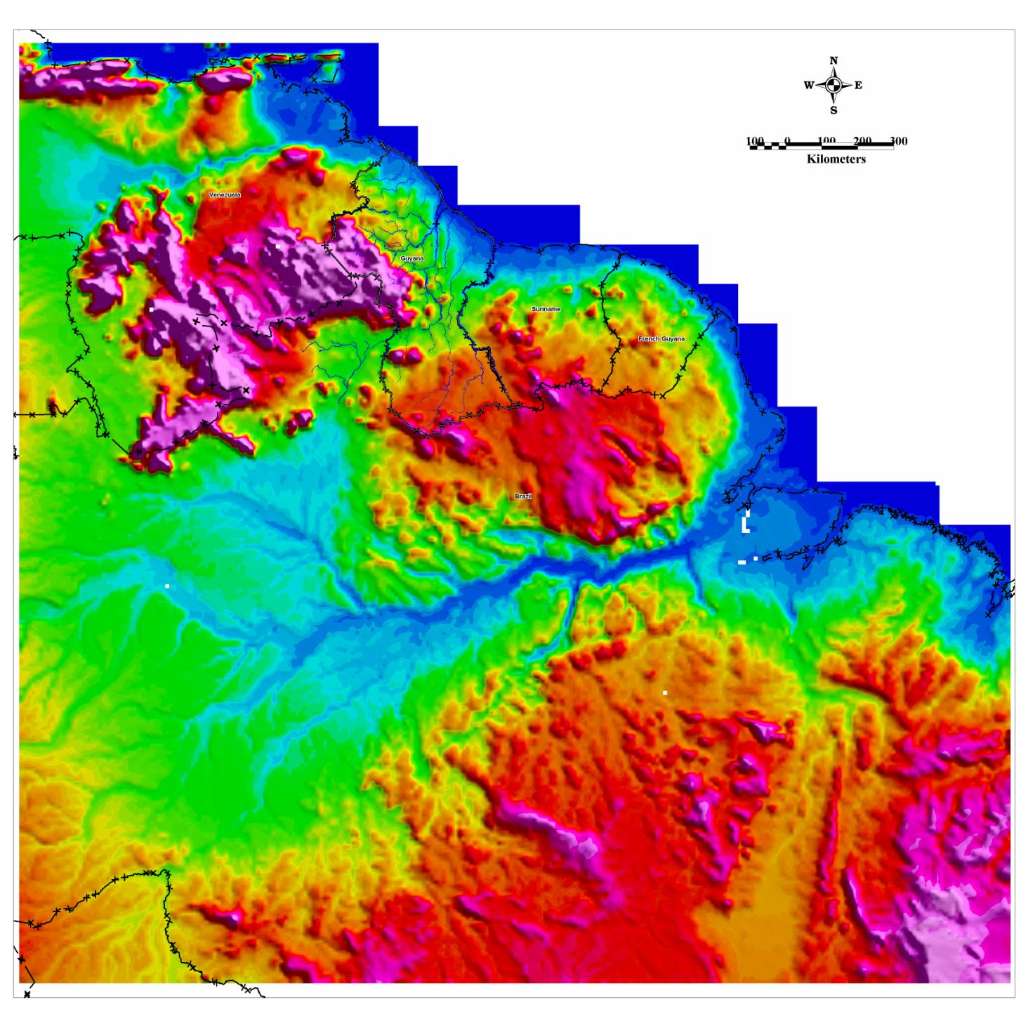
Figure 1. Digital Elevation Model of South America showing the Location of Guyana in
relation to the Amazon River
VENEZUELA
GUYANA
SURINAME
FRENCH
GUIANA
BRAZIL
AMAZON RIVER
Source: Guyana Geology and Mines Commission , 2006
8
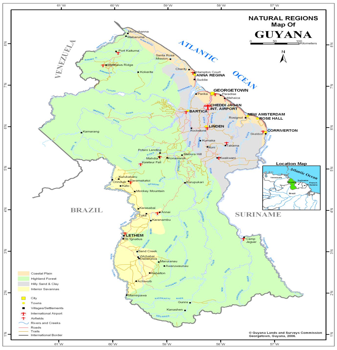
Figure 2
Source: Guyana Lands and Surveys Commission, 2006
All of these rivers flow to the Atlantic Ocean in addition to the following smaller ones, viz:
the Pomeroon and Moruka, in the north-western part of the country, and the Boerasiri,
Mahaica, Mahaicony and Abary, in the south-eastern part.
9
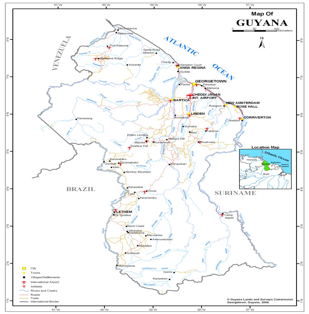
Figure 3. Hydrological Map of Guyana
Source: Guyana Lands and Surveys Commission, 2006
Besides these rivers, there are the Takutu River and its tributary, the Ireng, which form the
south-western limits of the country. The Takutu flows thence to the Rio Branco, a tributary
flowing into the Rio Negro which is a confluent of the Amazon River.
1.1.2
Hydrology
Guyana is one of eight countries sharing the Amazon Basin. Its main river, the Essequibo is
one of the principal rivers of South America with a mean flow of 2100cu.m/s. Much of the
Hinterland area is drained directly or by major tributaries of the Essequibo and fresh surface
water is generally plentiful for most of the year. There are a number of surface water sources
water comes from
10
such sources. A Multiple Cluster Survey (2001) found that 25% of people in the Interior
reported using rainwater as an improved source (and a similar percentage in the rural Coast).
But the potential of rainwater as a source of domestic water needs to be determined for each
of the geographical sub-divisions.
Even though Guyana is rich in water resources, most of the surface water and some of the
groundwater requires treatment to make it potable. Most surface water is liable to
contamination and many surface sources fail in the dry season. An understanding of water
resources is necessary for planning both the quantity and quality of water to be supplied
(Hinterland Strategy, 2004). The Hinterland Strategy (2004) further stated that water
resources for the Hinterland can be divided into separate areas associated with the
geographical sub-divisions:
Interior Plains Area
The White Sands Formation, located in the northern Interior Plains region and in the southern
Coastal Lowlands region, yields moderate to large quantities of fresh water from depths of
less than 30m. This formation is centered in Linden and also provides the origin of the
groundwater percolating into the A and B sands aquifers used in Coastal areas. In the north-
western Coastal Area region, large quantities of brackish to saline water are available for
abstraction at depths ranging from 3 to 30m. This groundwater is poor due to continuous
saturation from tidal flooding.
Southern Plains and Western Highlands
Groundwater is generally plentiful from sedimentary and volcanic deposits in the southern
and western regions of Guyana. There is a paucity of potable groundwater in the central
mountainous area of the Hinterland known as the Guyana Shield where only fractures and
small perched discontinuous aquifers produce water. The depth to the water table ranges
from 3 to 300m depending on the location of the well or borehole and levels may also vary
with the season. Hinterland water sources currently include groundwater obtained from
springs, shallow wells; deep hand dug wells and drilled boreholes.
1.1.3 Geology
Guyana lies within the Amazonian Craton, which forms part of the South American
Continent (Brazil, Bolivia, French Guiana, Guyana, Suriname and Venezuela). The Amazon
Craton is subdivided into two geographic shields, the Guiana Shield in the North (in which
Guyana is situated) and the Central Brazil (Guapore) Shield in the south. The Guiana Shield
is composed mainly of the Maroni-Itacaiunas Province which is a large continuous province
present in French Guiana, Suriname, Guyana, North Brazil and Venezuela. The province
contains rocks representing an early Proterozoic crust with a strong south-east structural
fabric. It is sub-divided into two terrains, a granulitic and gneissic terrain and granite
greenstone terrain which covers a large proportion of Guyana. Guyana is geologically sub-
divided into three provinces, the Northern Province, the Southern Province and, between
them, the Takutu Graben (Guyana Geology and Mines, 2006).
11
Northern Province
The Northern Province is subdivided into three main geological units; the Greenstone Belts,
the Roraima Group and the recent Tertiary/Quaternary deposits (see Figure 4).
Takutu Graben/Northern Savannahs Rift Valley
The Rewa Group, which includes the Takutu Formation and Apoteri volcanics, occupy the
Takutu/Northern Savannahs Rift Valley, which is bounded by the Kanuku Mountains in the
south and the Pakaraima Mountains in the north. The rift valley/graben extends for 180km
into Brazil to the west and is up to 50km wide (see Figure 4).
Southern Province
The Southern Province is located in the central part of the Guiana Shield. The nucleus of the
Proto-Kanuku Complex. The Proto-Kanuku Complex is composed of high metamorphic
grade migmatitic gneisses and granulites, which were involved in the Imataca thermo-
tectonic event. The Proto-Kanuku Complex forms a horst which is part of an east-northeast
trending mobile belt known as the Central Guyana Granulite belt, which extends into
Suriname to the east and Brazil to the west (see Figure 4).
1.1.4. Economic Deposits of Guyana
Several economic minerals are exploited in the Guiana Shield. The main economic minerals
mined or that have potential for being mined in Guyana are: gold, diamonds and bauxite (see
Figure 5).
1.1.5.
Population Size
The 2002 Population and Housing Census showed that the population of Guyana rose to
751,223 persons higher than the 1991 census by a little more than 27,500 persons (see
Figure 6). This new count was in keeping with trends of population change for Guyana,
which has shown an increase at each census, except for the 1991 census when for the first
time in history the count was lower than that of the previous census. The population decline
at census 1991 appeared consistent with the peak emigration flows recorded during the
decade of the 1980s. The average annual rate of growth for the population has also reversed
from its negative trend of the 1980s (seen in 1991), but the census survival ratios between
1980 and 2002 show a heavy influence of emigration on the distribution (Guyana Population
and Housing Census, 2002).
12
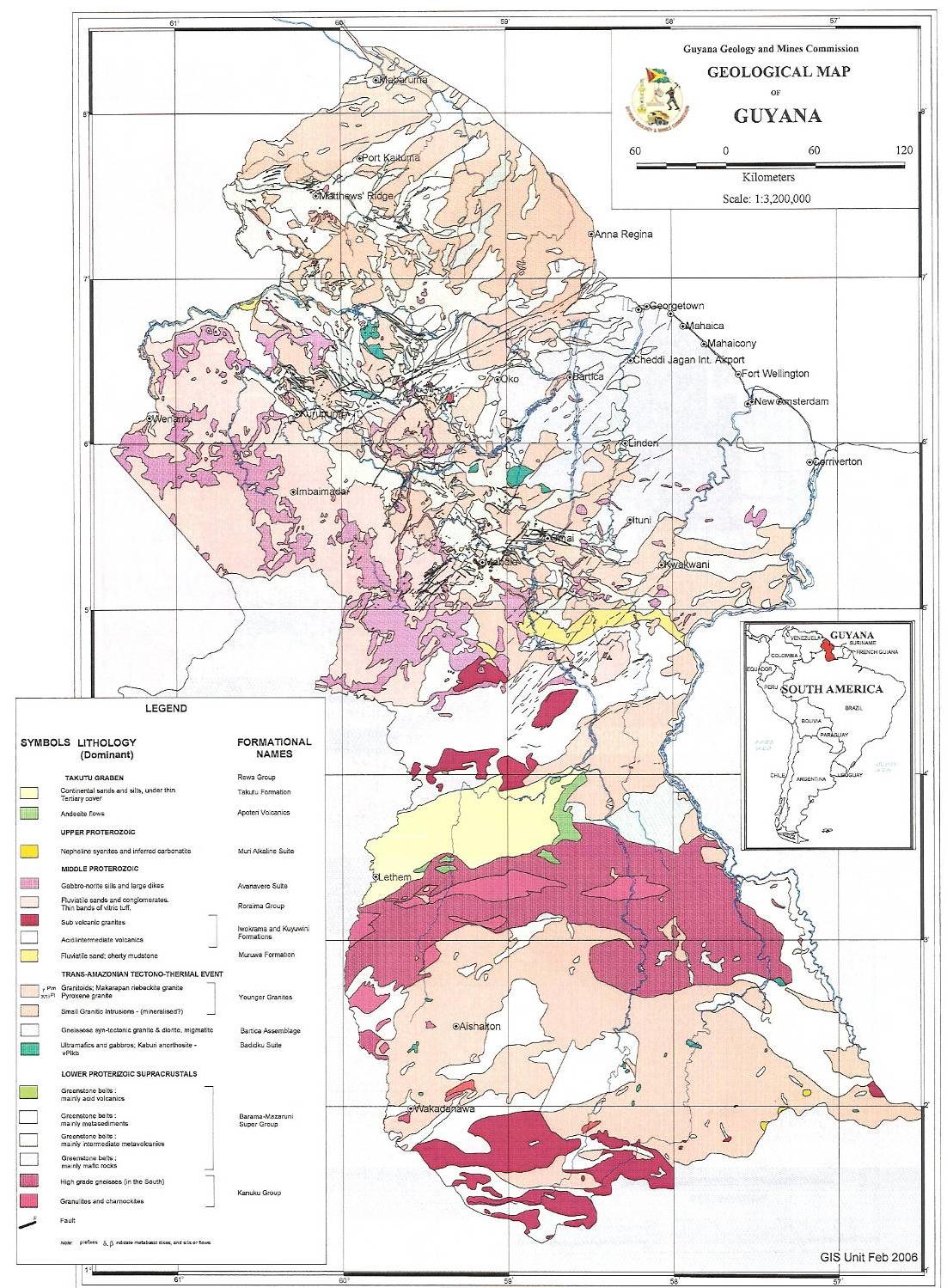
Figure 4. Geological Map of Guyana
Source: Guyana Geology and Mines Commission, 2006
13
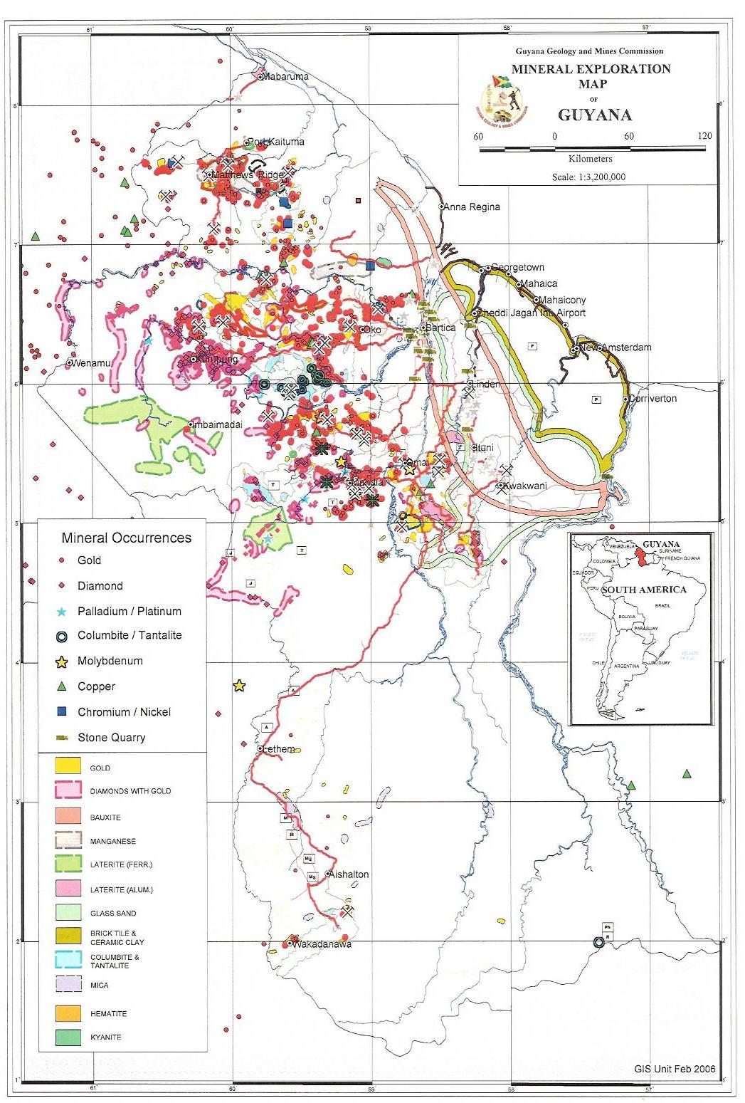
Figure 5. Mineral Exploration Map of Guyana
Source: Guyana Geology and Mines Commission, 2006
14
Figure 6.
Source: Guyana Population and Housing Census, 2002
Regional Population
The 2002 Census report showed that the main areas of population concentration have not
changed over the decades, although some of the sparsely populated regions had begun to
grow (see Figures 7 and 8). Region 4, where the capital city Georgetown is located, had
over 40 percent of the population and Regions 3 and 6 combined had another 30 percent. The
population of Region 8 though small, however, rose sharply more than doubling its size,
i.e., from 4,485 in 1980 to 10,095 in 2002. The four main hinterland Regions (1, 7, 8 and 9),
though covering nearly three-quarters of the total land area of the country were sparsely
populated and consisted of less than 10 percent of the population (Guyana Population and
Housing Census, 2002).
Regional Population Density
The region with the highest population density was Region 4 (where the capital city is
located) with 139 persons per square kilometre. Region 4 alone had about 41.3 percent of the
population but contained only 1 percent of the land area. Next in rank were Regions 3, (27
per sq. km), Region 5 (13 per sq. km) and Region 6 (3 per sq. km). Regions 1, 7, 8 and 9
consisting about 67.6 percent of the land mass were sparsely populated (see Table 1 and
Figure 9) (Guyana Population and Housing Census, 2002).
15
Figure 7.
pulation Distribution by Gender
Source: Guyana Population and Housing Census, 2002
Figure 8. Regional Population Growth Rates, Guyana: 1980-2002
Region 1980-1991
1991-2002
Region 1
0.05
2.43
Region 2
0.24
1.10
Region 3
-0.80
0.63
Region 4
-0.61
0.39
Region 5
-0.45
0.20
Region 6
-0.61
-1.25
Region 7
0.25
1.53
Region 8
2.04
5.17
Region 9
1.42
2.23
Region 10
0.22
0.33
Total -0.44 0.33
Source: Guyana Population and Housing Census, 2002
16
Table 1. Regional Distribution of the Population, Guyana: 1980 -2002
1980
1991
2002
Region
Population Percent
Population Percent
Population Percent
Region 1
18,329 2.4
18,428 2.5
24,275
3.2
Region 2
42,341 5.6
43,455 6.0
49,253
6.6
Region 3
104,750 13.8
95,975 13.3
103,061
13.7
Region 4
317,475 41.8
296,924 41.0
310,320
41.3
Region 5
53,898 7.1
51,280 7.1
52,428
7.0
Region 6
152,386 20.1
142,541 19.7
123,695
16.5
Region 7
14,390 1.9
14,790 2.0
17,597
2.3
Region 8
4,485 0.6 5,615 0.8 10,095
1.3
Region 9
12,873 1.7
15,057 2.1
19,387
2.6
Region 10
38,641 5.1
39,608 5.5
41,112
5.5
Total
759,567 100
723,673 100
751,223
100
Source: Guyana Population and Housing Census, 2002
1.2.
Existing Plans and Programmes
Water Resource Plans and Climate Change Assessment
The current period of research revealed no current or formal Water Resource Plans or Water
Basin Plans per se. However, the Guyana Water Incorporated is currently preparing its
Strategic Plan which should include data on the water supply and distribution system on
and sources of water
extraction (see Table 2). The work of the GWI is supported by the recommendations of the
Poverty Reduction Strategy Paper (PRSP) 2004. These recommendations were to:
Drill wells in communities that lack access to potable water
Develop a National Rehabilitation and Maintenance Plan
Increase the budgetary allocation to procure chemicals, pumps and other essential parts
necessary to improve water infrastructure
Expand public awareness programs on home treatment of potable water and water
conservation
In the Hinterland of Guyana, access to water is limited due to thick vegetation, isolation of
settlements and a lack of all-weather roads. The reliability and accessibility of water systems
have been identified as a key health factor because when the more distant water systems fail,
communities tend to revert to closer, frequently more polluted sources. The two most
significant challenges for Hinterland water resources are seasonal variations and
environmental pollution. The quality and reliability of surface water abstraction vary, with
water quality in particular being regularly threatened by mining, forestry and the activities of
the communities themselves. A number of the small creeks and shallow wells that many
small and medium sized communities rely on for drinking water are seasonally unreliable
(see Table 2 for drinking water sources).
17
Figure 9.
Source: Guyana Population and Housing Census, 2002
Table 2. Percentage of the population using different drinking water sources, Guyana, 20002
Main source of water
Percentage
Im
proved
unimproved
Piped into dwelling
4.2
-
Piped into yard or plot
5.3
-
Public tap
1.2
-
Tube well/borehole with pump
1.0
-
Protected dug well
7.0
-
Protected spring
0.7
-
Rainwater collection
25.0
-
Bottled water
0.5
-
Unprotected dug well
-
15.1
Unprotected spring
-
4.7
River or stream
-
34.3
Tanker truck vendor
0.1
-
Other -
0.9
Total 44.9
55.1
Source: Hinterland Strategy and Report, 2004
2 Report of Multiple Cluster Survey, Guyana, Bureau of Statistics, July 2001.
This data is based on the survey carried out in 2000, during the implementation of the El Ni�o
Emergency Assistance Project. (From: Hinterland Strategy, 2004).
18
The recent El Nino drought highlighted this issue, and as a result the United Nations
Development Programme (UNDP) set up the El Nino Programme, through which deeper
wells have been constructed for a number of communities throughout the interior. A
particular concern in the Hinterland is the environmental damage caused to surface water
sources by small scale alluvial gold mining. This type of mining tends to be immensely
destructive of the water course itself, especially with the use of poisonous heavy metals to
refine the gold recovered. Given the small scale and isolation of these sites, they are difficult
to regulate and can seriously jeopardise water supplies.
Coastal Agricultural Water Supply
It is also important to note that water for the supporting agriculture on the Coast comes from
ighland region. There is a complex drainage and irrigation network
established to capture, store and distribute rainfall water from the Highlands of Guyana to
Coastal Guyana. This system is monitored by the Drainage and Irrigation Authority, and was
extensively described by Mott MacDonald (2004). In addition to the system of capturing
line are utilized as natural irrigation and drainage systems.
Water and Climate Management and Monitoring
The Hydrometeorological Service, Ministry of Agriculture operates the National
Meteorological Station Network (NMSN) and the National Hydrological Station Network
(NHSN) (Mott MacDonald (2004). Figure 10 shows the Hydrometric Network for parts of
Regions 3, 4, and 6. Hydromet has the responsibility of monitoring water bodies and
climatology throughout Guyana. Maps for the National Hydrological Station Network are
currently being developed for Hydromet with support from the Guyana Geology and Mines
Commission.
By collecting, processing, archiving, retrieving and analysing the data from both Networks,
Hydromet is able to provide information to those agencies that are planning and designing
also analyses the lower and upper atmospheric weather data of the western hemisphere, and
disseminates the information to the aviation and other sectors. The department maintains
several databases with pertinent data on hydrology and meteorology, including the CLICOM
database that is used for precipitation and meteorological data and HYDATA which is used
for archiving streamflow data. The data collection network includes a number of
organisations (e.g. Guyana Sugar Corporation) (Mott McDonald, 2004).
Monitoring Hydrology
Hydromet has
more than one-hundred and fifty (150) hydrological stations comprehensively covering
The NHSN includes a raingauge network and a
streamgauging network (Mott McDonald, 2004). Data from these collection stations are held
in the World Meteorological Organisation (WMO) compatible database HYDATA and the
database contains data for most of these stations from the year 1950 2006. However, there
are instances where data may be missing for some stations for periods of time; indeed there
are currently only 17 stations in operation nationwide.
19
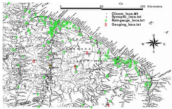
Figure 10. The Hydrometric Network of Regions 3, 4 and 6
Source: Mott McDonald, 2004
Monitoring Climatology
The Hydrometeorological Service monitors a network of Meteorological Stations throughout
Guyana. There are currently 102 rainfall stations operating in Guyana (Appendix 2) and
seven (7) of these are synoptic; meaning that they have the capacity to monitor the major
parameters of weather and climate: temperature, rainfall, wind speed, etc. Hydromet
publishes monthly bulletins on weather conditions in Guyana and provides advice to farmers
on prevailing weather conditions and possible impacts of the weather on their agricultural
practices.
Recent Climate Studies
Guyana has ratified the United Nations Framework Convention on Climate Change
(UNFCCC). A Climate Change Action Plan was developed in 2002 to achieve the objectives
and meet
commitments of the UNFCCC. The Action Plan recognised that it was
imperative for climate change activities to be developed to ensure that Guyanese were
prepared to deal with the impacts of the consequences of global warming (Climate Change
Action Plan, 2002).
Prior to the preparation of the Action Plan, Persaud and Persaud (1995) classified the rainfall
regions of G
conditions were made by Seulall (2005) and Mott MacDonald (2004). The following were
results from these efforts:
20
1. Rainfall Distribution
McGregor and Nieuwolt, 1998 in Seulall (2005) reported that Guyana had a wet tropical
climate. However, because of geographical influences such as mountains and ocean there
was spatial variability of rainfall resulting in three major climate types. Three rainfall
regimes were identified in Guyana (Persaud and Persaud, 1995) which can be divided into
different subcategories in order to define different rainfall regions (see Figure 11). Persaud
and Persaud (1995) showed that the highest annual rainfall occurred in the mountainous area
of Guyana, with the lowest annual rainfall in the savannahs. Their work resulted in the
classification of 17 rainfall-climatic regions. They further referred to the three major rainfall
regimes as:
Tropical savannahs or very dry regions - Areas with annual rainfall less than 1788
mm. Such areas were located in the Rupununi Savannahs, the Intermediate Savannah
(south of Guyana), the Upper Cuyuni (north west of Guyana) and the Corentyne Coast.
The Corentyne Coast was found to be much drier than places further inland.
Very wet tropical rainforest climate (very wet regions) - These were areas with annual
rainfall exceeding 2728mm. These regions were found in the Pakaraima Mountains, the
upper Akarai Mountains and the sub coast.
Wet/dry tropical rainforest (wet/dry regions) - The remainder of country experienced
this type of climate. These were areas with annual rainfall between 1778 mm and 2800
mm.
2. Mean Annual Temperature
Along the coast of Guyana, average daily maximum temperatures were 29.6oC, while the
average daily minimum temperatures were 24.0C. Diurnal variation of temperature was
smallest here because the maritime effect was more pronounced (McGregor and Nieuwolt,
1998 in Seulall 2005). Seasonally, temperatures were higher in the dry periods with the
highest temperatures occurring in September and October and the lowest in May and June. In
the Highlands Regions, especially, over the Mountainous Region temperatures were the
lowest (Seulall, 2005).
Seulall (2005) described four main mechanisms - Inter Tropical Convergence Zone (ITCZ),
El Ni�o - Southern Oscillation (ENSO), Tropical Easterly Waves and Squall Lines that
affects
3. Climatic Norms
Mott McDonald (2004) noted that the prevailing climatic and weather conditions may be
impacted by climate change. Using available data for Region 3, 4 and 6, Mott McDonald
(2004) made the following conclusions:
Temperature data for Timehri Airport were available from 1971, and sunshine data from
1987. Data at Georgetown Botanical Gardens were available for a much longer period, with
were for a common period
1962 2002. The climatic norms at Timehri Airport and at Georgetown Botanical Gardens
showed little variability. Mean daily temperatures were generally between 26 0C and 27 0C,
with higher temperatures being experienced in September and October when mean daily
maximums exceeded 30 0C. The range in mean daily temperatures was lower at Georgetown
Botanical Gardens than at Timheri Airport, reflecting the stronger maritime influence at
21
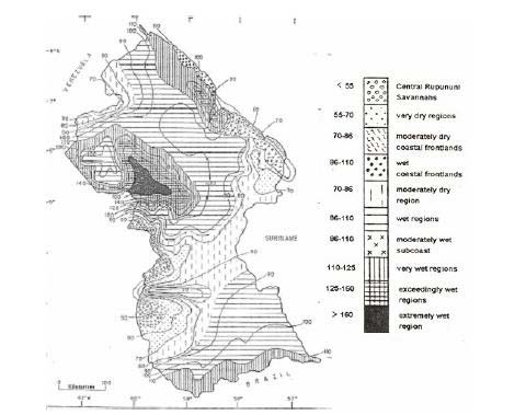
Figure 11. Very Wet Tropical Rainforest Climate or Very Wet Regions of Guyana
Source: Persaud and Persaud 1995
Georgetown. The recorded relative humidity values at Georgetown were lower than at
Timehri, by about 5% on average. The maximum and minimum values of relative humidity
and mean monthly values over the record period indicated inter-annual variability. There
were lower values of relative humidity in February and March, and in September and
October, corresponding with the two dry seasons. Wind speeds, like the other climatic
parameters varied little throughout the year. Maximum wind speeds tended to occur in the
period February to May. At the time of preparing this report, only a short period of historic
wind speed records for Georgetown Botanical Gardens had been collated by the Hydromet
Department - 1996 to 2001 (Note that continuous wind run data does not exist).
The pattern of daily sunshine hours showed maximums in the two dry seasons of February
March and August October. Georgetown had more sunshine than Timehri Airport, and this
in part explained the differences in relative humidity between these locations. The maximum
and minimum values gave an indication of inter-annual variability. Mean annual rainfall in
Georgetown is 2300 mm. It is of interest to note that the greatest variability in monthly
rainfall occurred in the months of December and January (See Figures 12 and Figure 13).
22
Figure 12. Climatic norms at Timheri Airport 1991- 2002
Source: Mott McDonald, 2004
Figure 13. Climatic norms at Georgetown Botanical Gardens (1962-2002)
Source: Mott McDonald, 2004
23
4. Influence of El Nino
It was reported (Guyana National Communication: Monitoring and Understanding Climate
Change and Impacts, 2002) that Guyana experienced droughts during El Nino events and
heavy rainfall and flooding during La Nina events. The El Nino is a warm coastal current off
the West Coast of South America and is associated with changes in the Walker Circulation
System over the Pacific. During an El Nino event there is a weakening of the Walker
circulation system, and during a La Nina event there is a strengthening of the Walker
Circulation System. The variability of the Walker circulation system is measured by the
Southern Oscillation Index (SOI), which is calculated by the difference in atmospheric
pressure (at sea level) between Tahiti and Darwin.
8The El Nino and the Southern Oscillation are thus two characteristics of the Walker
Circulation System, and the combined term ENSO is often applied. The SOI provides an
objective means of measuring the strength of ENSO activity. Figure 14 shows a time series
plot of the SOI over the period for which rainfall records exist for Georgetown. Negative
values of the SOI are associated with El Nino years.
Figure 14. The Southern Oscillation Index, 1882 2002
Source: Mott McDonald 2004
5. Possible Impacts of Climatic Change
Initially a brief review was undertaken of the General Circulation Model (GCM) predictions
of future climate conditions in Guyana. The HadCM2GSal model was looked at in particular.
The indication from this model was that precipitation in Guyana was likely to reduce under
scenarios of future climate change. All models indicated a reduction in annual precipitation
in the range of 5 10%, and an increase in temperatures of about 1.5 0C. All models and all
scenarios indicated reduced rainfall in the months of September December. December and
January rainfalls have historically shown the greatest variability. The clear indication was
24
that between June and December it will become drier, and this will be of significance for
irrigation during the September November dry season, while reduced rainfall from June
may lead to more severe drought conditions. The forecast changes were consistent
throughout the year and the indication was that a temperature rise of 1.0 1.5 0C may be
expected by the 2040s. A temperature rise of this order could increase evaporation by up to
5% if other parameters remained unchanged.
6. Sea Level Rise
A change in sea levels will influence the drainage characteristics along coastal Guyana. As
relative sea level rises in Guyana, the result will be a reduction in the period of time for
which gravity drainage can operate, which in turn may eventually lead to increasing
dependency on pumped drainage.
Guyana was of the order of 10 mm/year on the basis of historic records. It was also reported
that the results from the CGCM 1 model indicated a mean sea level rise along the Guyana
coast of about 4 mm/year during the next century. Interestingly, the mean sea level published
in tide tables for Georgetown, indicated that the mean sea level is now 0.158 m higher than it
was in 1951. This equated to a rate of relative sea level rise of 3 mm/year. The Transport and
Harbours Department (T&HD) established the change in mean sea level on the basis of their
records of sea level and historic sea level records for Georgetown were provided by
Hydromet. These records dated between 1951 and 1979. However, Hydromet have not until
recently had a responsibility for sea level records, and with the exception of some very recent
data with Hydromet, post 1979 data have not been located despite several avenues of
investigation. A progressive rise in recorded maximum sea levels was noted between 1971
and 1976. This followed a four month period of missing data in 1970. It is therefore possible
that following an instrument failure, or similar, the gauge datum changed or was unstable
from 1971 onwards. Recent data for 2000 indicated that the 1971 1976 data was
anomalous. The 2000 maximum level was close to the long term mean.
Monitoring will be essential to the planning of future coastal defence and drainage works. It
was strongly recommended that procedures for sea level monitoring be strengthened. This is
a key variable for Guyana and its importance is increasing as global sea levels rise.
Rainfall Characteristics
Mean annual rainfall was determined using a standard record period of 1974 2002, this
being the most complete period of record in the Hydromet CLICOM database. No attempt
was made to infill periods of missing data as the isohyetal plots of annual data were intended
only to provide an impression of annual rainfall totals. Figure 15 shows mean annual rainfall
for the 1974 2002 periods. Stations with significant periods of missing data were excluded
from the analysis, and at many stations the sum of monthly means had to be used as there
were too many incomplete years of annual totals. Rainfall in Region 3 was generally in
excess of 2,500 mm, while in Region 6, annual rainfall was of the order of 1,750 mm (Mott
McDonald, 2004). The impacts of global climate change are discussed in more detail later in
this section.
25
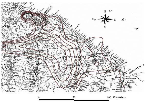
National Inventory on Greenhouse Gases
A national inventory was first conducted in 1994. It was revealed that Guyana was a Net
Sink country for CO2 where removals (26,664 Gg) greatly exceeded emissions (1446 Gg),
that is, a removal balance of 25,218 Gg in the base year 1994. The Energy sector (fuel
combustion activities) was the major emitter of CO2 having CO2 emissions of 1446 Gg in
1994, while the Land Use Change and Forestry sector was the major sink for CO2, with the
net removal sink of 26, 664.47 Gg in 1994. Carbon dioxide was the major Greenhouse Gas
being emitted, accounting for 96.5 % (1446 Gg) of the total emissions of CO2, CH4 and
N2O in 1994. The Agricultural sector was the major source of CH4 and N2O emissions
totaling 51 Gg and 1 Gg respectively in 1994.
Figure 15. Mean Annual Rainfall for Regions 3-6 for the years 1974 2002
Source: Mott McDonald, 2004
Impacts of Climate Change and Sea Level Rise
While Guyana was reported as a net sink for greenhouse gases, it was most vulnerable to the
impacts of climatic change. The records in Guyana suggested an increase of 1.0 OC in the
mean annual temperature of Georgetown over the period 1909 to 1998. Cooling periods in
the record appeared to be a result of the influence of major volcanic eruptions in several parts
of the world. Prior to 1960, annual rainfall amounts were generally above or about normal.
From 1960 and onwards, there has been a tendency for below normal rainfall. ENSO events
have severely affected Guyana especially in the last decade of the twentieth century.
The Atmosphere Global Circulation Model (A-OGCM) of the Canadian Centre (CGCM 1)
was used to develop predictions of rainfall, temperature, evaporation and water deficit for
two scenarios of carbon concentration: doubling and tripling. For a doubling scenario,
temperature was expected to rise by 1.2 OC in the period 2020 to 2040 from present. Highest
26
increases in excess of 1.5 OC were expected in southern Guyana in the Second Dry Season
(August to October). Rainfall was expected to decrease by an average of 10 mm per month
but the decrease in the First Wet Season and Second Dry Season (May to October) will be 12
mm per month or higher. Evaporation, however, appeared to show insignificant increases
(less than 3 mm per month). Water deficit will be about 8 mm per month on average with
larger deficits in southern Guyana.
With a tripling of CO2 concentration in the latter part of the twenty-first century, Guyana
could experience a temperature rise of 4.2 OC on average. Here again, southern Guyana may
experience highest increases. Rainfall can decrease by an average of 21 mm per month with
higher decreases in the First Wet Season (FWS) and Second Dry Season (SDS). Again,
southern Guyana could be influenced by the highest decreases. Evaporation is likely to
increase by about 3.3 mm per month. Southern Guyana may experience large water deficits
in the First Wet Season and Second Dry Season while northern Guyana is likely to be
affected by deficits in excess of 22 mm per month.
Similar predictions were made by the Hadley Centre A-O GCM for the tripling of CO2,
except that lower temperatures and more severe decreases in rainfall were expected
especially in the First Wet Season.
Past Sea Level Rise
Tidal gauge data in Guyana for the period 1951 to 1979 indicated a mean relative sea level
rise of 10.2 mm per year. High tide change was calculated to be 9.7 mm per year with the
low tide change being 11.1 mm per year. This was about 5 times the global average and
suggested
coast, such as
subsidence due to water extraction, ocean floor sediment loading or plate tectonics. Plate
tectonics did not appear to be contributing to this observation. But, subsidence and sediment
loading may both be contributing to the high rises noted in Guyana.
Future Sea Level Change
The Global Circulation Models (GCMs) indicate average rises of 2 to 4 mm per year in the
first half of the twenty-first century and rises of 3 to 6 mm per year in the latter half.
Therefore, in Guyana, sea level is projected to rise by about 40 cm by the end of the twenty-
first century. If meltwater contribution from land ice is considered, then the rise can be about
60 cm. The predicted sea level rise coupled with extremes in rain events and storm surges
and increased wave action can exacerbate an already critical situation where water
accumulatio
defences.
Climate Change Impacts
The impact of climate change on water supply is not very clear. Decreasing rainfall and
increasing evaporation can lead to lower water levels in the rivers. Extreme rainstorm events
can allow for flood conditions especially during cold phase ENSO events. Sea level rise can
result in salt water intrusions further upriver. Ground water can also be vulnerable to this
effect. The demand for water is expected to increase with increasing temperatures and the
relative value of water for alternative uses would likely change, as priorities are determined
on the basis or urgency of needs.
27
The energy sector will also be affected. Demands for interior space cooling and possibly
decreased hydro-generating potential supply from some river basins can pose problems.
Shifts in the seasonality of river discharges and reduced rainfall will have to be considered in
determining hydropower sites and periods of water storage. In terms of hydropower
generation, runoff potential and hence the hydro-generating capacity of certain drainage
basins may decrease, in turn,
cheaper and non-fossil fuel form of energy.
In the agriculture sector, using analyses based only on changes in climatic variables, yield
by increased water demands from crop transpiration and greater respiration losses as a
consequence of higher temperatures. There may be changes also in the yield quality due to a
decreased diurnal temperature range, resulting in, for example, decreased sucrose content,
with sugar as stated earlier being most affected. There is uncertainty in assessing the effect of
fertilizers and pesticides on crop yield due to the projected increase in temperature. It is
possible that the adjustment of levels of fertilization may be an effective stabilizing response
in extreme years.
Spatial shifts may have to be considered as climate change takes effect. There may be the
need for a substantial switch of crops or species of crops in particular areas. In addition,
changes in farm profitability can be expected to affect non-agricultural sectors of the
Guyanese economy. There would need to be studies to determine the advantages of increased
CO2 concentration and the effects of increased temperature, rainfall and evaporation on the
major crops in Guyana.
A CO2 induced climate change can impact on the forestry sector in a similar way to that
for agriculture. There would, however, be a need to consider the impact of increased CO2
fertilization on forest growth. If the dry seasons get drier, then this may impose severe
constraints on forest growth and may be critical in determining species response. With a
doubling CO2 concentration, indications are that the forests in southern Guyana may be
affected by shrub savannah spreading southward to replace tall evergreen forest. With a
tripling CO2 concentration, the same areas can be affected. However, the northwest may also
be affected by a change to shrub savannah types. Again, the sensitivity analysis must be
guided by further studies.
The Coastal Zone is identified as being the most vulnerable part of Guyana because sea
level rise will be expected to add to the direct impacts of temperature rise, rainfall decrease
and evaporation increase. It is also the part of Guyana where adverse impacts will directly
affect a large percentage of the Guyanese population. Two vulnerable zones have been
identified in the coastal zone. Impact Zone 1, comprising the western Essequibo areas where
the coast is not protected by man-made structures and Impact Zone II is the densely
populated regions comprising Berbice, Demerara and the eastern part of Essequibo that are
protected by man-made structures. In both zones, drainage is a problem. There would be a
need to develop programmes to address the issues of coastal stress taking into consideration
the impacts of climate change and sea level rise. Further, decisions would have to be made,
on the basis of detailed analyses, about areas that shall be protected or accommodated or
perhaps abandoned in the face of accelerated sea level rise. Since the coastal zone affects a
large percentage of the population, it will be necessary to examine the implications of climate
28
change for water resources (effects of salinity on estuaries and aquifers), agriculture,
fisheries, human settlements, human suffering and loss of lives, tourism and health.
Available evidence strongly suggests that Guyana has long recognised its bountiful natural
resource wealth as capital for development. Probably the most profound action towards
attempting to utilize this was the establishment of the Iwokrama International Centre in 1989.
its resource to fuel the development process, but that it recognised that such development
must be done in a manner that would have minimal impacts on the environment, whilst at the
same time bringing lasting benefits to current and future generations of its people. The quest
for development had to be tailored in such a way that the lessons learnt by other countries
who had similar ambitions and who indeed had achieved some level of economic
development, were duly acknowledged and capitalized on.
1.3.
Other Relevant Plans and Programmes
vision for sustainably managing its part of the Amazon Basin would be built upon
past initiatives; some of these are highlighted in this section.
1.3.1. National Development Plans
Two key documents were produced over the past few years that focused primarily on
national development. Both documents recognised that there was a need for development and
that one of the ways to go about it was to focus on reducing poverty. The first of these was
the National Development Strategy (NDS) which was released in the year 2000 and
represented a comprehensive consultation process between the Central Government and Civil
Society. The document presented a policy framework for Guyana on all the critical areas of
development, namely: Governance; Macro-economic Strategy and the Management of the
Economy; The Environment; Information Technology; Energy; Transport; Sugar; Rice;
Agricultural Institutions; Non-Traditional Agriculture; Fisheries; Forestry; Water; Mining;
Manufacturing; Education; Health; Tourism; Urban Development; Land; Housing;
Amerindians; Gender Issues; The Family and Its most Vulnerable Members; Labour and
Employment; The Private Sector; and Poverty Eradication.
Since the publication of the NDS a number of important policy documents have been
developed, these included: a National Environmental Action Plan, a National Biodiversity
Action Plan and a Forestry Code of Practice.
The second document of major significance that has been produced recently is the Poverty
Reduction Strategy Paper (PRSP) in 2005. The PRSP, like the NDS, focused on a number of
areas that needed addressing in order to reduce national poverty, including water, where it
expressly stated:
-term strategy in the Water Sector will be dedicated to
improving the quality and delivery of services, ensuring good and effective regulation
of the sector, and implementing a subsidy program to help poor households connect
to the system and/or pay a portion of their monthly bill. Specifically, the objectives of
the Water Sector will include (i) provision of access to safe water to 95 percent of the
population; (ii) establishment of a Guyana Water Company to provide economies of
29
scale; (iii) streamlining of the activities in the Coastal Zone with emphasis on
treatment of raw water; and (iv)implementation of a comprehensive rehabilitation
and maintenance plan. In addition, more chemicals will be procured to treat raw
water, maintain sanitary conditions in and around water conservancies, and the
Ministry of Housing and Water (MOHW) will coordinate its program with the
Drainage and Irrigation Department of the Ministry of Agriculture, as poor
maintenance of Drainage and Irrigation schemes is partly blamed for the
contamination of water systems. MOHW will also mount public awareness programs
to educate families to conserve and treat water. Priority attention will be given to
rehabilitation and maintenance of water infrastructure. In part, frequent damage to
water mains due to old age, low water pressure, and low levels of maintenance
compromise the quality and availability of water. To deal with these problems, the
MOHW in collaboration with the water agency will prepare a multi-year
comprehensive rehabilitation and maintenance program, for which an increased
budgetary allocation will be granted. To improve access to water, about 100 wells
will be drilled, 50 windmills constructed and over 400 pumps installed in hinterland
areas in the medium term. Pumping stations will also be rehabilitated and/or
constructed in several hinterland areas. In addition, Government will rehabilitate
over 150 minor water systems, involving the replacement of pumps and engines and
refurbishment of electro-mechanical systems in rural areas. These improvements will
bring immediate benefits to over 200,000 residents. In municipal areas, the focus of
the water program will be the construction of additional ground storage tanks, and
the drilling of new wells
(For more information please see http://www.povertyreduction.gov.gy/index.html)
1.3.2. Resource Management Plans
1.3.2.1. National Protected Areas System
There are at least five (5) sites in Guyana that has been earmarked for protected area status:
The Kanuku Mountains, Mount Roraima, Orinduik Falls, Shell Beach, and the South-Eastern
Forest. The following site descriptions were extracted from: www.epaguyana.org.
Kanuku Mountains
There is a distinctive type of vegetation on granite domes and steep cliffs in the Kanuku
Mountains region, and it has been shown to be rich in birds including Harpy eagles and a
diverse mammal fauna. Surveys revealed that 250 species (about 75% of all forest-based
species in the country) occur within a few square kilometres of lowland evergreen forest.
About 7 or 8% of these species are endemic to lowland forests in the Guianas. In all, 350
bird species are recorded in the region
entire avifauna occurs in the Kanuku Mountains. Mammal surveys indicate that 80% of the
biodiversity of the region reflects the unusual diversity of habitats, which range from
savannah, gallery forests, and semi-deciduous forests in the lowlands, to lowland and
montane evergreen forests within an elevation range of approximately 150-900 m.
30
Mount Roraima
This area contains many elements of the Guiana Shield flora and fauna that are found
nowhere else. Mount Roraima (2800 m) is the highest tepui in Guyana and mostly
inaccessible from Guyana. These tepui mountains are poorly studied in Guyana but known
to be rich in unusual plants and animals on the Venezuelan side. This area is located across
the border from the National Park in Venezuela and the forests protect an important
watershed that is vital to Guyana. Mount Roraima contains several vegetation types from
lowland rainforest to elfin woodlands. This area has been proposed as a World Heritage Site,
and as a national park.
Orinduik Falls
Located north of Lethem on the border with Brazil, Orinduik Falls is one of the oldest
geological formations in the country and has scenic rapids, which interlink with plant
communities. The falls are surrounded by dry savannahs. The area has been proposed as a
national park, a natural monument and as an important site for conservation.
Shell Beach
Located at the mouth of the Waini River, the beach is a vast bank of shells, approximately 10
km in length. The area helps protect against drastic changes in the coastline. The area is one
of the most important nesting areas in the world for four species of sea turtles that are being
actively studied. However, the rest of the flora and fauna have not being studied and it is the
only place left in Guyana with large intact mangrove, brackish water, and coastal swamp
communities.
Poaching of sea turtles still occurs, despite ongoing monitoring and
conservation initiatives that involve local Amerindian communities. This area has been
proposed as a wildlife sanctuary.
South-Eastern Forest
This is a vast area in southern Guyana on the border with Suriname and Brazil. The portion
Landing has been visited a few times by botanists and mammalogists and
preliminary data indicate that this forest is very different from the other forests found in
Guyana. Two collectors, one for termites and ants, and the other for mammals have briefly
visited the far eastern portion, the New River Triangle. These preliminary data suggest a rich
and unexplored flora and fauna with many possible new records for Guyana and undescribed
species. Both of these areas are believed to contain low elevation, high canopy rainforest.
The New River Triangle has been proposed as a resource reserve and an important area for
conservation.
(Please see www.epaguyana.org for more information)
There has been a significant amount of work done in the Kanuku Mountains with leadership
from Conservation International (Guyana) and at Shell Beach with leadership from the
Guyana Marine Turtle Conservation Society (GMTCS). When declared as Protected Areas,
these areas will join the Kaieteur National Park and Iwokrama International Centre for
Rainforest Conservation and Development on the list of National Protected Areas.
1.3.2.2.
Natural Resource Management on Amerindian Lands
Amerindian communities that hold legal title to their lands, by virtue of their ownership of
the land have jurisdiction over all natural resources, with the limited exception of sub-surface
31
resources and waterways that pass through their lands. In recognition of the fact that they
have control over these resources, the Village Councils have been charged under the
Amerindian Act 2006 to put systems in place for the management of their natural resources.
In response, the Ministry of Amerindian Affairs has supported the communities of the North
Rupununi, Region 9 to pilot a process that will lead to the development of a system for
sustainably managing their natural resources.
The process and product have met the communities expectations and they have now
requested that the guidelines outlined for the development of the natural resource
management system to be officially gazetted as by-laws
-Laws for the Management of
Natural Resources by
reviewed by all the national agencies with responsibility for the management of natural
resources in Guyana to ensure that they have met, at the very minimum, standards established
for the management of natural resources on state lands. The Ministry of Amerindian Affairs
plans to support the transmission of this system and the process that lead to the creation of
this system to all other Amerindian communities in Guyana. This would attempt to ensure
that the systems for the management of natural resources on Amerindian lands would be on
par or even exceeding the standards established on state lands.
1.3.2.3 The Rupununi Wetlands Project
The Rupununi Wetlands, just southeast of the Iwokrama Forest, includes the Rupununi,
Rewa, and Essequibo Rivers, and many other smaller rivers, creeks and ponds. These
wetlands contain high habitat diversity and support a vast array of wildlife. Although only a
small portion of the area has been surveyed, over 400 species of fish have been identified.
This has led to estimates of up to 600 species for the area; remarkably high compared to
other South American wetlands. The high fish species richness results, in part, from seasonal
flooding that links the Amazon basin to the flooded Rupununi Savannahs. The Rupununi
Savannahs and mountain streams of the Pakaraima foothills are also major fish-breeding and
feeding grounds during the high water period. The Rupununi Wetlands, like the Iwokrama
Forest, are also home to healthy populations of rare and endangered giants including Giant
River Turtles, Black Caiman, Arapaima, Giant Otters, and of course, water-loving Jaguars.
Through the collaborative efforts of the Darwin Initiative for the Survival of Species,
Iwokrama, the University of Guyana, the Environmental Protection Agency and the North
Rupununi District Development Board (NRDDB), the monitoring programme aims to
develop a better understanding of the impacts of different land uses on the wetlands. The
project commenced in January 2004 and has approximately 30 study sites within the
Iwokrama Forest, along the rivers and along the savannah of the North Rupununi.
Monitoring efforts aim to observe seasonal changes in the vegetation, water chemistry and
land use activities (www.iwokrama.org).
1.3.2.4.
Hydropower Development
The Hydro-Electric Power Act, CAP 56:03 provides the legal framework for the
development of hydroelectric power generation in Guyana. There are a number of sites in
Guyana that have been identified for the development of hydropower facilities (Appendix 1).
It has been estimated that Guyana has the potential to produce a total of 7000MW of power
from hydropower (Kaehne, 2002). At the moment about five (5) of these sites are receiving
significant attention from the Government of Guyana and its development partners for
32
establishing hydropower plants. Of significant note are Amalai in Region 7, where a 2000
Mega Watts (MW) facility is being explored. Marshall Falls in Region 7 (1100 MW) and
Tumutumari (35 MW) are also receiving attention for developing hydropower facilities at
this point in time (Honourable Samuel A. Hinds, Prime Minister, personal communication).
1.3.3. Soils and the Environment
The National Agricultural Research Institute (NARI) is the repository institution for soils in
Guyana. NARI is currently spearheading research on soil and land use surveys, management
of aquatic weeds and soil management. Soil surveys are in various stages of completion in
Bonasilm, Leguan and Canal # 1 Polder; the results should provide information on the soil
resources of these areas. The digitising of reconnaissance soil maps of Guyana, at
1:1,000,000 and 1:500,000 scales have been completed. A land evaluation exercise has been
conducted of the Lima Sands area on the Essequibo Coast and recommendations have been
made for management of these soils.
Aquatic weed management work has focussed mainly on collaborative activities with the
East Bank Essequibo Development Project. Two herbicides have been identified as
promising for aquatic weed control. Recommendations have also been made to use the
herbicide Round-up (glyphosate) and Arsenal (Imazapyr) for vegetation control on the edges
along embankments.
In soil physical management, two projects have been done to determine the effect of bed size
on soil moisture utilization and the effect of organic waste material on sod physical
properties and weed management. The bed size has no significant effect on moisture content,
although the long dry season may have affected the results, whilst it appeared as though the
organic matter improved the soil physical properties to some extent.
1.4.
Biodiversity and Forests
1.4.1 Biodiversity
Guyana has remarkable diverse habitats and a rich flora (plant life) and fauna (animal life)
which remains largely unexplored. It is unique in the world because the majority of its
natural resources remain in a pristine state. While Guyana is one of the smaller countries of
the wider Amazon region, it contributes significantly to the biodiversity, both in terms of
number of species and number of endemics. Its natural ecosystems are relatively intact due
mainly to low population pressure and to limited commercial activity. The importance of the
Amazon B
magnitude of endemism, its role in ameliorating global climate and the hydrology of a large
part of South America. Guyana is home to thousands of species of plants and animals, and it
is widely suggested that many are unknown to scientists.
Current increase in entrepreneurial activity in the natural resources sectors, places pressure
on the biological resource base and raises real possibilities of increased threat to biodiversity.
The situation is compounded when it is considered that there is a limited knowledge of the
extinction.
The Centre for the Study of Biological Diversity (CSBD), a collaborative effort of the
University of Guyana and the Smithsonian Institute, is the repository for the Guyana National
33
he CSBD holds the most
comprehensive collection of specimens of plants and animals found in Guyana, Suriname
and French Guiana. More than 25,000 plant specimens are housed in the National Herbarium.
The Zoological Museum contains species of invertebrates such as insects, butterflies and
moths, and vertebrates such as fish, birds, snakes and other reptiles, frogs and other
amphibians, and mammals. It should be noted that The Smithsonian Institute holds data on
the diversity of Guyana and the entire Guiana Shield and such data can be requested from the
institute at: www.si.edu.
(Please see http://www.sdnp.org.gy/csbd for more information).
There are a number of efforts aimed at building a tradition in support of participatory
decision-
natural resources. These policies are reflected at the national level in the signing of a number
of international and regional treaties, conventions and other instruments relating to the
conservation and sustainable use of natural resources. In keeping with this,
Cabinet
recently approved a National Biodiversity Plan, which seeks to promote conservation and
su
biodiversity (Guyana
Initial National Communication, 2002), and recently has developed a Biodiversity Action
1.4.2 Forests and Forestry
The Forest Resources
The forest of Guyana covers some 16.45 million hectares or 76.6% of the total land area. Of
this area only about half (8.7 million hectares) is considered accessible for economic
exploitation. This forest is generally considered tropical moist, evergreen rainforest, though
represented by various forest types. The permanent State Forest Estate, which covers some
13.58 million hectares, is administrated by the Guyana Forestry Commission (GFC). The
remaining forest areas are Private Property, Amerindian Community Titled Areas or State
Lands administered by the Guyana Lands and Surveys Commission.
The forests are heterogeneous in nature. About 70 species of timber are regularly extracted,
with another forty (40) species being extracted in a more irregular manner. The forestland is
dissected by many large rivers that provide a means of transporting forest produce to the
processing centers. Some of these rivers, however, are very difficult to navigate due to
masses of rock outcrops in their channels and periodic low water patterns.
Forest Values
preservation of the Amazon Basin Watershed. Water conservancies have been established for
the supply of irrigation water upon which the agricultural industry is dependent. Watersheds
that supply these conservancies are mostly white sand areas where much of the forest cover
has been lost due to bauxite mining, agriculture and the intensive harvesting of fuelwood.
Annual flooding of low lying coastal areas is a frequent problem attributed in part to this
forest clearance. It is important that the watersheds are put under a multiple-use management
regime with the primary management objective being the maintenance of good watershed
characteristics.
34
The biodiversity of the forests has been the subject of a number of surveys and studies,
mostly by foreign universities and institutions. The Smithsonian Institute which has co-
operated with the Government of Guyana in the establishment of a Biodiversity Centre in
Guyana has conducted systematic studies of the flora and fauna. A National Biodiversity
Strategy has been approved by
Cabinet, which establishes national regulations
governing the prospecting of biological and genetic resources and protects intellectual
property, particularly of the indigenous Amerindian people.
Administration of Forest Areas
Forests are allocated to loggers under a three-tiered system. Firstly, there is the State Forest
Permission (SFP), which is granted for small, short-term operations (two years) and where no
heavy investment is required. The SFP does not give exclusive rights to the area it covers.
Holders of State Forest Permissions generally concentrate on the production of fuelwood
(charcoal and firewood), posts and timber. Where the area exceeds 400 hectares, an acreage
fee is payable.
Secondly, there is the Wood Cutting Lease (WCL) which grants rights to extract timber and
other forest produce for periods between 3-8 years. Simple forms of Management Plans are
required and a stipulated minimum royalty level is a vital obligation under this system. The
areas granted are much larger than those under the State Forest Permission.
Thirdly, there is the Timber Sales Agreement (TSA), which is considered the major wood
cutting license currently being granted to large operators. This level of operation requires
large investment and sufficiently large areas (over 25,000 ha) to amortize the investments.
These licenses (agreements) grant harvesting rights to the grantee for the period of 15-25
years. Under this system, it is essential that a detailed forest inventory and Management Plan
be prepared and submitted to the Guyana Forestry Commission for approval. To date,
approximately six (6) million hectares of accessible forest have been allocated, of which
about 3.7 million hectares are under TSAs (see Figure 16 for allocation of National Forests).
In Guyana, emphasis is placed on formulation and implementation of Forest Management
Plans not only for exploitation, but to apply appropriate systems to ensure forest
conservation, forest protection, forest for multiple benefits and long-term sustained supplies
of wood for industrial and energy needs (Guyana Species Booklet, 2004). The GFC has also
published a Code of Practice for Timber Harvesting which gives guidance to persons about
the standards of harvesting state forests. This document and other GFC publications can be
downloaded from www.forestry.gov.gy.
Rain Forests
Rain forests occur in areas where the climate is wet, with rain occurring every month or
where dry spells are short. Trees are numerous and stand in strata or layers, ranging from low
shrubs to very tall dominant trees with large spreading crowns. Climbers and epiphytes
are abundant. In Guyana, rain forests are the most common forest type, occurring from the
35
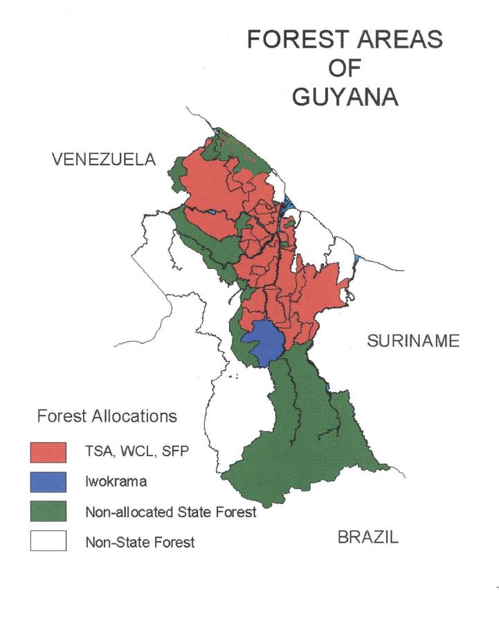
Figure 16.
Source: www.forestry.gov.gy
north-west through to the south of the country. It is also the most important type for timber
production. Seasonal forests (also known as monsoon forests) occur where there are regular
dry seasons. Trees are not as tall and the top of the forest canopy is more even. In the dry
season, the larger trees often lose their leaves. Climbers and epiphytes are less abundant.
Seasonal forests are found in Guyana in the north Rupununi and the upper Berbice areas.
Dry Forests
Dry forests occur where soil moisture is frequently limited either because the soil drains
rapidly or where there is excessive evaporation due to strong winds. Examples of dry forest
are found on the white sands of the Soesdyke-Linden highway and throughout the Pakaraima
Mountains. Wallaba forests are common in the white sand regions.
Seasonal Forests
Swamp forests occur where drainage is impeded and soils are frequently waterlogged. This
forest type includes the mangrove forest along the coastline and the Mora forests occurring in
lowland swampy areas and along the interior. Mangrove forests provide protection to the
shoreline against erosion and are an important habitat for marine life. Removal of
mangroves for fuelwood from the Essequibo River to the Corentyne has not only exposed
lengths of coastline to erosion but also degraded these ecosystems, limiting their ability to act
as nurseries for pelagic fish species. An estimated 75 percent of fish caught commercially
spend some time in the mangroves or are dependent on food chains which can be traced back
36
to these coastal forests. Mangrove plants and sediments have also been shown to absorb
pollution, including heavy metals. Mangroves along the north-west coast are still largely
intact. An evaluation of the mangrove resource is to be carried out by the Guyana Forestry
Commission and plans for its protection and management are to be developed. (Please see
www.forestry.gov.gy for more information).
2.0.
DYNAMICS OF CHANGE
It is well documented that the world freshwater resources are under threat from human
development and anthropogenic activities and changes in global climate conditions. Due to
future. However, a number of forces have been identified as driving forces behind global
change.
2.1. Driving Forces of Change
There are a number of areas that have been identified as the major drivers propelling the
global water scenarios: demographic this includes population growth, migration pressures
and urbanization; economic economic outputs; trade; prosperity; water works investment;
technological hi-tech expansion; water efficiency; unit water pollution; adoption of new
crops; water sanitation investment; number of desalinization plants; withdrawal efficiency;
social lifestyles, poverty, inequity; governance power structure ; level of conflict;
globalization; environmental water related diseases; soil salinity; groundwater; and
ecosystem health.
Many of these driving forces are visible in Guyana and indeed, in the wider Amazon Basin,
and therefore, would need to be considered when shaping the scenarios for future
in order to observe if
some of these driving forces are active in this part of the Basin
2.2.
Future Scenarios
2.2.1. Overview
situation. Future management strategies would be built upon the visions and programmes
soil resources and sustainable development. These key agencies took the opportunity
presented by the National Vision workshop to share their current programmes and plans for
the future that allow for the determination of plausible outcomes of the future sustainable
arrive at a national position for short, medium and long term scenarios.
It should be noted that these scenarios did not only focus on the Water Sector, but they
attempted to address the subject of sustainable development on the whole. The full
presentations from these key institutions and social actors are presented in Annex 4, whilst
37
the following section presents a summary of the scenarios developed from the National
Vision Workshop.
These scenarios are not to be used solely to estimate future supply needs, but they should
provide a starting point from which to evaluate various management options including, but
not limited to:
1. Moderating water demand through demand management programs, changes in water
prices, and efficiency programs and;
2. Increasing water supplies through urban water re-use facilities ground water reclamation,
recharge, and conjunctive use, increased water storage and conveyance, and
desalinization.
2.2.2. Short term: 5-Year Scenarios
2.2.2.1. Overview
In the short term, it is expected that much of the current trends aimed at improving
environmental management and the development of the national population of Guyana would
continue.
In addition, the current policy aimed at improving the Water Sector with respect to the
delivery of potable water to a wider cross-section of the Guyanese population would also
continue. This would include changes in the system for water delivery with the likely
implementation of more efficient systems of delivery, and also the likelihood that customers
would be required to pay for the potable water, especially along the coastal plain and
particularly around Georgetown.
Also, in the short term,
currently being utilized for environmental purposes would be directed towards agricultural
and industrial activities (agricultural and urban water use) as these areas are developed. Some
of the likely developments are summarised below:
2.2.2.2. Water Policy
The National Water Council is expected to begin functioning as mandated in the Water and
Sewerage Act 2000, with the National Water Policy being developed and implemented
accordingly. The implementation of the Act would result in a greater role from the key
agencies with stipulated roles by the legislation.
The Act has been developed to allow for a concerted effort at sustainably managing and
the monitoring of climatic and
other factors that may impact upon this resource. At the moment, however, the Act is not
being implemented to its full force, thereby not allowing for many of its credible intentions to
be achieved. In the short term, it is hoped that there would be more effective implementation
of the Act allowing for greater protection and sustainable utilisation of water resources in the
Guyana.
2.2.2.3 Hydrometeorological Monitoring
Currently, the Hydrometeorological Service is in operation on a minimum of its human
resource requirement (forty-five (45) persons). This shortage of staff is greatly affecting the
38
ability of the Service to meet all of its very important obligations. It is estimated that in order
for the Service to fully meet its mandate it would need to have a staff of approximately one
hundred and twenty (120) persons.
Nevertheless, in the short term, the Service hopes to improve its ability to forecast weather
events through the acquisition of a new Doppler Radar. The Service also plans to improve its
ability in hydrological monitoring.
The Service appreciates its role as current trends of greenhouse gas emission and global
warming are expected to continue, which would accelerate the hydrological cycle and lead to
an increase in the amount of carbon dioxide (CO2) in the atmosphere. This increased CO2 in
the atmosphere would result in increased rainfall intensity, which in turn would lead to
shorter wet seasons, longer dry seasons, higher temperatures and higher transpiration rates.
Higher transpiration rates would result in plants using more water, whist more intense rainfall
would lead to a greater loss of top soil. These two conditions would require more irrigation
water to be available for agricultural crops and food production and sedimentation of
waterways. Further, increased sedimentation of waterways would also affect tourism
activities such as naviga
If these current trends should continue, they would impact on agriculture in the short term
and the shorter wet season would affect t
farmers in a very difficult situation. The Service therefore hopes to continue its current policy
of producing information bulletins to assist farmers in their planning. Because the Service
clearly recognises that the helpfulness of such bulletins would depend on good quality data, it
realizes that it must get its systems of monitoring in a position to deal with these changes.
2.2.2.4 Domestic Water Supply and Demand
With the changes in the Water sector over the years, water is now being treated as a
commodity to be traded like any other commodity on the market and is therefore influenced
by market forces demand and supply.
The Guyana Water Authority (GWI) as the sole public supplier of water currently supplies
urban water supply (see Figure 17). As a part of its
plans, the GWI is working to improve potable water supply and within the next five years,
the company aims to supply potable water to ninety percent (90%) of the population of
coastal Guyana. It should be noted that in the same time frame, the GWI aims to bring
The Housing and Population Census (2002) suggested that the national population has
fluctuated over the past twenty-two (22) years or so. However, the Census also suggested that
there has been an increase in the national population. This would certainly translate into a
greater demand for this precious resource. The national development initiatives are expected
to begin bearing fruit in the short term with a larger portion of the population being better off
and more likely increasing in their sophistication and taste resulting in greater demands for
potable water.
39
2.2.2.5 Agricultural Water Supply
As a part of the national drive to improve agricultural productivity, the Drainage and
Irrigation Authority would aim to improve drainage and irrigation facilities nationwide.
Much work is expected to be undertaken during the short term to bring irrigation water to
areas of the country that were not traditionally under cultivation. It is expected that the
drainage and irrigation facilities in the traditional agriculture areas would be improved to aid
increased agricultural production.
2.2.2.6 National Development Efforts
A number of efforts (National Development Strategy, Poverty Reduction Strategy) have been
made in the past and a number of national programmes are working towards sustainable
development in Guyana (see Section 1). Efforts would continue to build upon these
initiatives in the short term, and it is expected that these programmes will begin to
demonstrate tangible benefits to the citizens of Guyana.
2.2.2.7 Agriculture
Agriculture continues to occupy a very interesting space in the drive for national
development. This is especially true with the growing demand for areas to be conserved, and
biodiversity protected. This translates into a competition for space for non-agrarian activities.
Nevertheless, it is clearly recognised that the provision of food for the national population is
crucial to any efforts aimed at sustainable development. It is therefore important that
agriculture and the impacts of agricultural activities on the sustainable development drive,
and more specifically in the management of transboundary water resources, be taken into
consideration in the overall planning activity.
The planning activity should take into consideration that agriculture related activities would
influence land degradation including: erosion and the leaching of chemicals into waterways.
These impacts have been recognised and a number of initiatives have been taken to try to
mitigate these impacts and are expected to bring results in the short term. These initiatives
include demonstrations on: composting (where vegetation is converted to compost instead of
being destroyed in traditional slash and burn agriculture), mulching, crop rotation, liming,
drip irrigation, revegetation and fertilizer use.
2.2.2.8 Land Administration
Land use planning is probably the most important aspect in the planning for sustainable
and utilized to bring optimum benefits to the population. Currently, the Guyana Lands &
granting of lands for consumptive and non-consumptive activities.
Over the past five (5) years the GL&SC has invested a considerable amount of resources
towards building the capacity and system that would allow it to better serve its mission. Its
achievements over this period included the completion of Land Use Policy and Land Use
Plans for Regions 6 and 9 of Guyana.
40
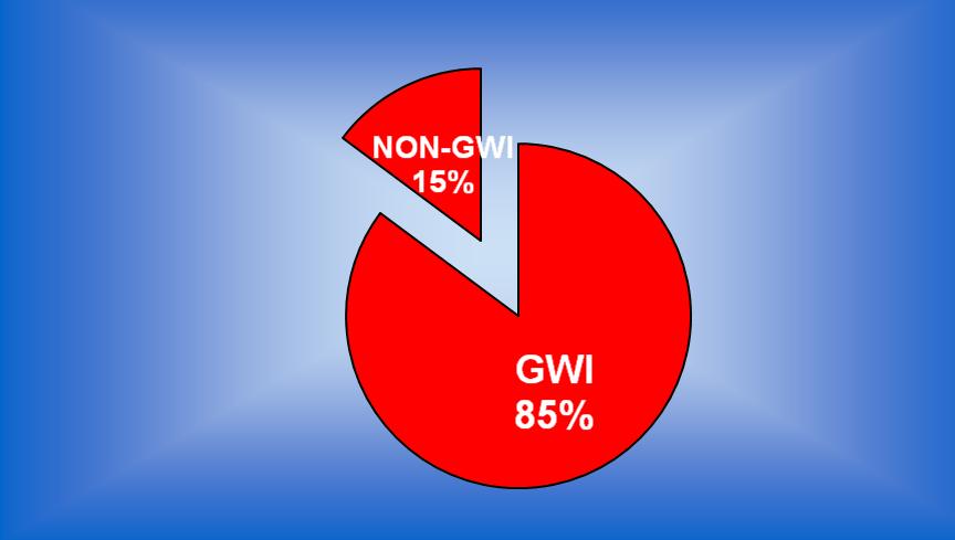
Figure 17. Water Supply to the National Population by the Guyana Water Incorporated
Source: Guyana Water Incorporated, July 2006
administrative regions. The GL&SC would also undertake baseline studies in support of
policy development, to formulate policies on land tenure, land allocation, land markets and
other land issues with a view of providing appropriate recommendations to the Government
of Guyana. It would also identify and implement areas of cooperation among stakeholders
with a view of ensuring sustainable land development.
It is expected, therefore, in the short term that greater attention would be placed on planning
and that this would translate into sustainable utilization of natural resources at the national
level.
2.2.2.9 Mining
The mining sector makes a significant contribution to the Guyanese economy, with the Gross
Domestic Product (GDP) and employment creation being the main areas to benefit. Despite
the positive impacts of mining to Guyana, the sector is still often chastised for its negative
impacts on the environment. These negatives include water pollution from chemicals and
pollution from run-off.
Recognising that the mining sector needs to take the environment into consideration, the
Guyna Geology and Mines Commission (GGMC) has a number of short term plans aiming to
monitor mitigation of these negative impacts: encouraging the use of tailing ponds, safe
use, handling and disposal of mercury and reclamation measures; establishing sustainability
in training and capacity building; increasing research and information gathering,; achieving
compliance with regulations (as a prerequisite to effective compliance monitoring);
developing and implementing environmental effects monitoring; introducing Cyanide use in
medium scale gold mining; and introducing gold recovery techniques that are more efficient
41
and minimize or eliminate the use of mercury; working with communities through the
employment of Community Rangers, District Mines Affairs Committees and projects to build
skills in reclamation, alternative livelihoods and alternatives to carnivorous fish diets for
pregnant/lactating women and children.
In addition, the GGMC would like to deepen collaborative partnerships with EPA, NARI,
GFC, Hydromet, UG, Ministry of Amerindian Affairs, Ministry of Local Government,
Ministry of Health and the Ministry of Agriculture.
2.2.2.10 Forestry
Currently, approximately fifty (50) percent of state forests have been allocated to logging
companies
logging currently and in the short term would be strictly monitored by a number of
instruments, including: the National Forest Policy, the National Forest Plan, the Forest Laws
and the Code of Practice for Timber Harvesting.
The Forest Code of Practice provides guidance on how forestry resources can be extracted.
The Code includes guidance on how trees are to be harvested in areas adjacent to waterways
rivers, creeks, gullies, swamps, lakes - so as to protect the integrity of these waterways. The
Code also includes guidance on operational aspects of forestry, such as: road building,
occupational health and safety and use of chemicals. The National Forestry Policy also
encourages logging companies to attain forest certification.
In the short term, it is expected that a new Forestry Act would be passed allowing for greater
environmental protection in forestry. More companies would be encouraged to attain forest
certification and
2.2.2.11 Population Growth
The Housing and Population Census (2002) strongly suggest that the national population was
gration into the
in mining activities.
2.2.2.12 Housing and Development
The current trend along the coast of Guyana is for old sugar cane cultivated areas to be
converted into housing areas. This trend is expected to continue in the near term.
It is believed that the development of roads for reaching settlements, forestry and agriculture
is not done in a manner that would result in minimal impacts on the environment. For
instance, roads are developed and sediments from excavation works easily find their way into
water courses. This could result in sedimentation in these waterways and impact on aquatic
organisms and ecosystems.
2.2.2.13 Research
The focus of research at the University of Guyana is to improve the quality of environmental
management decision making. Particular attention is paid to advancing the uptake of research
information. It is recognised that improved linkages and interactions should be facilitated
42
between researchers and end-users, that is, policy and decision-makers. An understanding
should be developed of how to create a favourable social environment - at national, district
and regional levels - in which science can best be used. It is hoped that greater collaboration
would be achieved between agencies in the short term, with research seeking to address
questions raised by the other sectors. Specifically, the area of Ichthyology: Fisheries Studies,
Inventory, Monitoring, Taxonomy and Secondary Succession of Aquatic Systems; Water
Quality: Parameters, Development and Impacts and Monitoring and Indicators would be
addressed.
2.2.2.14 Energy
The current drive in the energy sector is to aggressively reduce the dependence on fossil
fuels. It is expected that in the short term greater efforts would be made with respect to the
development of renewable energy sources, including hydropower, solar and wind.
Summary
In the short term, if the current trend continues, there is a good chance that many of the
degradation. There could be a loss of aquatic biodiversity and a reduction in water quality.
There is a good chance that the problems that currently exist in terms of low access to water
supply and sanitation and the need for better food production practices and environmental
degradation would not be resolved.
Continuing with the current trends would therefore lead to the natural and socioeconomic
systems reaching their limits in the medium to long term. Increasing scarcity of renewable
and accessible water resources and diminishing water quality would further narrow the
resource base of healthy ecosystems. This could lead to chronic problems and a good chance
that catastrophes could result which may trigger national crises.
2.2.3. Medium-term: 10-Year Scenarios
From the discussions, it appeared likely that in 10 years time Guyana would be aiming
towards a resource use regime that is less resource intensive, and more focused on improving
the efficiency in which natural resources are utilised. This change would be influenced
primarily on the shortcomings presented by the Current Trends.
ken towards
ecosystem purposes. In the forestry sector, for instance, it is likely that all activities would
be made to stringently adhere to instruments such as the Forest Code of Practice. Other
forest use protocol would be adhered to - ensuring that waterways in the forests are protected
and vegetation in catchment areas are not destroyed. More efforts would be made to ensure
that forest and non-timber forest products are carefully utilized in order to bring lasting
benefits to the Guyanese people, with greater efforts for value added processing of timber
products.
The demand for water would grow, making it necessary for investments in establishing more
efficient systems for water delivery and potable water processing. This would, however, tend
to result in improved equity, efficiency and sustainability of the water sector. It should be
43
noted that the current trends in the water sector do strongly suggest that this is the direction
in which the water sector is likely to move.
As the water sector expands, there would be higher prices and possibly increased investment
in the sector. These new developments would encourage the private sector to invest in its
research and development. This renewed interest in research could result in greater
involvement of research institutions such as the University of Guyana and make the role of
the Hydrometeorological Service more critical in this era.
Ground water aquifers and coastal water supply would be areas that would receive increased
research and interest as well. The current assessment of sea level rise and implications for
It is
be that the coastal aquifers will be infiltrated by saline water from the sea. These impacts
may become more pronounced in the medium term, giving even more importance to the role
of the Hydrometeorological Service.
These changes would more than likely demand that greater attention be placed on improved
water management and water productivity. For example, the agricultural sector would be
affected and there would even be a need for developing new crops and examining the option
of moving cultivation from coastal to inland Guyana. This introduction of new crops into
areas that are currently covered with other vegetation types would mean that there is a shift in
water use. The introduction of crops would require irrigation - removing water that would
have previously been used for environmental purposes to agricultural areas. The movement
of cultivation from coastal to inland Guyana would also require that new water storage areas
be established inland as agriculture would demand that water storage facilities be in place for
proper crop support.
At the same time, the increasing population and the impact of current programmes aimed at
improving the livelihood of the Guyana population would probably result in an increased
demand for water. More of the population would be requiring water for basic life functions,
and the creation of new wealth could result in persons using more water for increased
domestic comforts - for instance, swimming pools and Jacuzzis. Even though absolute
poverty may be reduced, income inequalities may increase, and at the detriment of the
environment.
The changing situation would require that the Water and Sewerage Act 2002 be put into full
oper
instance, the Hydromet Service recognises that it would need to be strengthened with specific
emphasis on: modernization and institutional development, expansion of monitoring
network, and the hiring of more trained staff. There would be a need for co-
operation/partnership between various organizations such as academia, Government
and so on; better decisions based on more complete and
accurate weather, water and climate information; partnerships to provide better data coverage
and information processing; higher resolution models and more precise and useful
specialized products.
44
In the mining sector, it is expected that more systematic exploration and mine planning
would be done by Medium Scale Miners. It is likely that there would be a greater mix of
Large, Medium and Small Scale Operations and a diversification in minerals exploited.
Improvements in the mining sector and increased investments are likely to result in
downstream value-added products such as alumina. With greater efficiency in the sector,
environmental practices are likely to improve, including reclamation and compliance with
regulations. At some point in the medium term, as well, it is likely that GGMC would be
able to decide how many Small and Medium Scale Operations would be allowed in an area.
Further, it is likely that this era would see a greater appreciation for ecosystem functioning
leading to more environmentally friendly mining. The sector may subscribe to the concept of
Landscape Forest Management that positively addresses mining.
2.2.4. Long-term: 20-Year Scenarios
In the long term, it is very likely that the national population would increase as the current
programmes to increase agricultural and industrial production would be bearing fruit.
However, increased population would also mean that there would be a greater demand on the
resources of the country. The current moves to improve environmental management would
also be bearing their rewards and there would be greater environmental awareness by the
population.
A more educated population would be aiming to achieve more sustainable values and
lifestyles. The current institutions for the management of natural resources, in particular,
water, would probably become more open and focus more of their energies on including
demand that their views are fully incorporated into the decision making process.
It is likely that many of these actions would emanate at the community-level, driving action
towards sustainable watershed management, rainwater harvesting and focusing on increasing
mean-yield levels in irrigated and rainfed areas. Decision-making in the water sector is likely
to be more transparent, involving all stakeholders as stated earlier. If this trend should prevail
then it would become likely that ecological functions are recognized and maintained with
human water use becoming sustainable.
It is during this era too that the current predictions on climate change and its impact would
begin to take effect on Guyana. The national population is likely to be more aware of weather
related issues and take appropriate action in response to warnings. The increased demand for
quality data to safeguard human well-being would probably determine that numerical
prediction models for both hydrology and meteorology be developed along with more
hydrometeorological stations being set up across the country, with responsibility for
hydrological and meteorological programmes. If the impacts of global climate change and
sea level rise begin to take effect then there would be a need for research of ground water
resources of the coastal artesian basin.
In keeping with the likely increased education and awareness of the national population, it is
likely that the population would request more information geological, water quality,
biological, watershed and related databases (GIS and GPS) that would lead to better
management of mineral resources development. It is likely too that the mining industry
45
would become more diversified, and more miners would want to comply with regulations
since they would then recognise the benefits.
The increased concern for the environment would require that there be more effective
collaboration between Agencies and Sectors. There is likely to be greater effective
participation in mining-friendly Landscape Forest Management. At this point too it is likely
that capacity would be built for environmentally friendly mining and monitoring by GGMC,
EPA, Miners and Communities.
These scenarios are plausible futures, not forecasts. They are differentiated by important
assumptions about uncertainties in water and other resource conditions. Materially different
future conditions can significantly affect the nature and outcome of various mixes of
management strategies. Some management strategies may be effective and economical
regardless of the future scenario. Other strategies may only be suited if specific conditions
develop in the future.
Developing quantitative estimates of water demands and supplies for multiple future
scenarios and management responses requires using available data and assumed
relationships. For Guyana, and the wider Amazon, we need to consider the current situation
and the way the various stakeholders with direct impacts on water resources would like to
design their various programmes. After all of these factors are taken into consideration, we
can develop future scenarios that can be used to guide the sustainable management of
3.0
RELEVANT TRANSBOUNDARY ISSUES AND PRIORITY THEMES
3.1
Transboundary Issues and Identification of Hot Spots of Common Interest
3.1.1. Transboundary Issues
The following were identified as being of significant relevant transboundary issues (in order
of priority):
1. Global Climate Change
Global climate change has been identified as one of the most important issues that would
confront the eight states of ACTO in the medium to long term. Climate change would impact
Guyana has identified a number of measures for dealing with the issue of climate change and
these are highlighted in the National Communication to the UNFCCC. The first
communication identified the various impacts that climate change would have on various
The second communication is
currently being prepared and would seek to address any gaps that may have been present in
the first communication and the UNFCCC requirements.
Climate change may determine that new crops be introduced for cultivation in Guyana. Such
new crops would affect the agricultural water use (irrigation water demand) and would be a
new factor to consider. The impacts of climate change, as described earlier in this paper
would be very significant for the coastal state of Guyana. As was explained earlier, one of the
46
impacts of climate change and sea level rise would be the intrusion into freshwater and
coastal aquifers of saline water. This would have definite impacts on coastal existence and
would lead to changes of the lifestyle in this part of the country. At the moment,
approximately 90% of the Guyanese population occupies the
oastal Plain region.
The impacts of climate change, providing they occur as gradual phenomena and not as one
time events, would force the Guyanese authorities to consider relocating the population
inland to occupy the highland regions of Guyana. This would impact directly on the forested
catchment areas of the country, and would probably lead to deforestation since population
movement would require new settlement development and associated services. The impact of
climate change would undoubtedly be felt by all eight countries sharing the Amazon Basin. It
is therefore essential that the monitoring of climate change occupy a top priority on the future
activities of ACTO and its eight member countries.
2. Population Growth/Transient Population
supply. An increase in the human population of Guyana would translate to more persons in
need for freshwater and greater demand for quality freshwater. This would impact directly
for environmental purposes would have to be taken up for the domestic/industrial water
supply.
from one
country to another could translate to the movement of attitudes towards water use and
protection for the aquatic environment from one jurisdiction to another.
The push and pull factors that result in transient populations need to be understood and dealt
with by each of the countries of the Amazon Basin. Further, some secti
population also have different cultures and beliefs with respect to the water bodies in their
communities, which would need to be understood for the future management of the
country
and as an extension,
With the National Development Strategy and the Poverty Reduction Strategy working
towards reducing poverty in Guyana, the end result would be a population that is better off,
with more economic opportunities available to them. This new wealth would bring new
desires and new levels of sophistication, which would more than likely translate to new
demands on water resources and water use.
3. Health
Water borne diseases especially in the hinterland areas of Guyana could become a problem as
the region faces climate change. Change in climatic conditions would create conditions that
may cause predisposing vectors of water diseases to proliferate at high rates. This could lead
to an increase in flood related diseases, and diseases related with general sanitation.
4. Sedimentation and Pollution
Anthropogenic activities such as agriculture, mining, forestry, housing development, and
tourism could have the likely impact of land degradation. When land is degraded it is easily
47
eroded and could find itself into waterways. These sediments (and other pollutants) could
then affect the aquatic life present in the watercourses.
soils that are easily eroded once the forest cover is removed. The conversion of such land for
agricultural purposes, in the absence of the most appropriate land management practices
would also lead to the loss of soil resources. Activities in the mining and forestry sectors
could also lead to pollution of the countr
and watershed management.
Pollution by agro-chemicals can have additional impacts including eutrophication.
5. Deforestation
Ecosystem health and watershed management are also areas that need consideration. The
removal of forests in forestry and mining activities, and failure to replant same, would in the
long term have an impact on the carbon sink potential of the country forests and rainfall
catchment areas.
6. Water Resources Use
GWI in its drive to bring potable water to a broad cross-section of the Guyanese population
would need investment in water sanitation, water treatment facilities and improvements in
water distribution systems to meet the needs of its customers. These investments would
immediately affect the nature of water use and distribution in the country, increasing the cost
of water delivery, and logically such costs would need to be recovered by the company.
Changes in this regard are already being observed as not so long ago water supply, albeit,
with its limitations, were free of charge. This has changed with users in many areas of coastal
Guyana being required to pay for every unit of water they use.
power generation. The development of such systems has tremendous potential in allowing for
a reduction in the dependence on carbon based fuels and therefore reduces the cost of future
power generation and emission of greenhouse gases. However, hydroelectric power
generation would bring a new demand on the countr
water resources, impacting on the
water that is normally used for environmental purposes.
7. Illegal activities including: fishing, wildlife, intellectual property rights
This aspect includes the movement of people and wildlife from one jurisdiction to another. A
good example of this situation is probably presented by the Arapaima gigas. This species of
fish moves freely between the Guyanese and Brazilian borders. The species is endangered in
both countries, with regulation enforcement believed to be stricter in Brazil than Guyana. As
search of the Arapaima.
The same situation may be applicable to other species of wildlife that may move between
these countries, encouraging persons from either country to travel to capture wildlife. Similar
situations may also be applicable for other member countries of ACTO.
While this free movement of people from one country to another is highly beneficial and
should be encouraged, it would require careful management to ensure the physical
environmental and ecosystem integrity are not compromised by such activities of a few
citizens.
48
8. Energy
The ever increasing price for fossil fuels on the global market place would affect all the
countries party to ACTO. There is therefore a need for the development of alternative
sources of energy. Hydropower is a very likely source of this new energy and is certainly
being pursued by some states. This source of energy also offers potential for sharing and
collaboration between the countries.
9. Navigation
The rivers of the Amazon Basin serve as a significant navigation route. The movement of
people and goods and services throughout the region has significant benefits as it can
improve trade within the region. Free movement can, however, have negative impacts if not
properly managed as this could allow for the movement of illegal materials. Indiscriminate
movement of vessels within the rivers of the Basin could have the greatest impact on the
ntegrity of water courses. Heavy traffic along the rivers could
result in the banks of rivers being eroded leading to increase sedimentation and subsequent
destruction of aquatic life. Noise levels from boats and traffic could also drive away birds
and other species of tourism interest away from the river banks affecting the profitability of
the tourism sector.
10. Investigate Transboundary Off-Site Effects
Many parts of the Amazon Basin region are interconnected although hydrology is not the
means by which the region is connected. There are similarities in forest cover in some
countries. This would suggest that there is a chance that the countries could be sharing the
same sources for water table, water cycle and spawning areas for aquatic species. Given
that ecosystems may be connected and similar there is a good chance that activities in one
part of the region would affect another part. This is of particular concern as it relates to the
extraction of resources such as water and the capture of fish species. This appears to be a
relatively gray area at the moment, and would therefore require some more investigation.
3.1.2 Hot Spots
A number of biodiversity hotspots have been identified by Guyana for future management.
Most of the areas highlighted here have been earmarked by the Government of Guyana for
protected area status in the future given their high biodiversity importance. The sites that
have been earmarked for protected area status are shown in Figure 18, whilst descriptions are
given below.
1. Kanuku Mountains
Rich in biodiversity: birds including Harpy eagles and a diverse mammal fauna.
250 species (about 75% of all forest-based species in the country) occur within a few
square kilometres of lowland evergreen forest.
About 7 or 8% of these species are endemic to lowland forests in the Guianas. In all, 350
bird species are recorded in the region, which suggests that well over 60% of the
Mammal surveys indicate that 80% of the count
Kanuku region. The apparent high overall biodiversity of the region reflects the unusual
diversity of habitats, which range from savannah, gallery forests, and semi-deciduous
forests in the lowlands, to lowland and montane evergreen forests within an elevation
range of approximately 150-900 m
49
Figure 18.
Source: Environmental Protection Agency, August 2006.
50
Close proximity to Brazilian border
2. Mount Roraima
Contains many elements of the Guiana Shield flora and fauna that are found nowhere
else.
Roraima contains several vegetation types from lowland rainforest to elfin woodlands.
This area has been proposed as a World Heritage Site, and as a national park.
Borders with Brazil
3. Shell Beach
The area helps protect against drastic changes in the coastline.
The area is one of the most important nesting areas in the world for four species of sea
turtles that are being actively studied.
However, the rest of the flora and fauna have not being studied and it is the only place
left in Guyana with large intact mangrove, brackish water, and coastal swamp
communities. Poaching of sea turtles still occurs, despite ongoing monitoring and
conservation.
Could be a good area to observe the impacts of climate change and sea level rise
4. South-Eastern Forest
This is a vast area in southern Guyana on the border with Suriname and Brazil.
Preliminary data indicate that this forest is very different from the other forests found in
Guyana.
Preliminary data suggest a rich and unexplored flora and fauna with many possible new
records for Guyana and undescribed species.
The area is believed to be of low elevation with high canopy rainforest.
5. Kaieteur National Park
Kaieteur National Park is Guyana
Further details on Kaieteur are given in Section 5.
6. Rupununi Wetlands
The North Rupununi (See Figure 19) and Iwokrama Forest Wetlands are of global
conservation significance with 88 bat species, over 400 types of fish and 500 bird
species.
The area also supports endangered species such as Arapaima, Black Caiman, Giant
Otter, Jaguar, Harpy Eagles and Giant River Turtles.
The area is the homeland of the Makushi Amerindians who rely on the wetlands natural
resources and habitats for their survival.
7. Amerindian Communities
There are more that 100 titled Amerindian communities in Guyana in addition to a large
number that are not legally titled.
Amerindian communities holding legal titles to the lands, have the authority to dictate its
regime for natural resource management.
51
Figure 19. Rupununi Wetlands
N o r t h R u p u n u n i
C o m m u n i t i e s
!
C
Mabaruma
!
C
!
P
!
P!C
!
C
!
C !C!C !C !P
!
P
Port Kaituma
!
P
1
Matthews' Ridge
!
C
Anna Regina
2
^
Paradise
Georgetown
3
!
(
Mahaica
Mahaicony
4
Oko
Bartica
Fort Wellington
!
( Linden
Rosignol
Kurupung7
Wenamu
5
Linden
Corriverton
Imbaimadai
Ituni
Omai
10
Mahdia
Kwakwani
8
!
<
Iwokrama
!
<
!
<
!
<!<
!
<
!
<
!
< !<!< !< !<
!
<
!
<!<
!
<
Lethem Le
!
( them
9
Aishalton
6
Wakadanawa
0
60
120
240
Kilometers
Source: Iwokrama International Centre for Rainforest Conservation and Development, July
2006
52
Amerindian communities are distributed throughout Guyana (Figure 18) and are therefore
critical in efforts aimed at sustainable environmental management, especially when an
ecosystem approach is adopted.
Differences in resource use regimes on Amerindian lands and lands adjacent to
Amerindian communities can result in a weakening in the national natural resource base,
including fresh water resources.
Therefore, Amerindian communities must be fully integrated into all natural resource
management plans, including those for water resource management.
3.2 Thematic Axes and Priority Themes for the Amazon
At the National Vision Workshop, the following areas were identified as being critical for
collaborative efforts between the countries signatory to ACTO.
3.2.1 Hydrometeorological Monitoring and Institutional Strengthening
Monitoring of hydrological and meteorological conditions is critical to the sustainable
development of Guyana and the Amazon region. The current system for monitoring needs to
be strengthened so as to allow for accurate accounting for changes in the region
hydrological conditions. The need for strengthening monitoring networks is emphasised
when it is considered that the Hydrometeorological Service is Guyana has reported that the
minimum requirement for operating the National Hydrological Network is a network
comprising of at least seventy (70) stations. At the moment, Guyana NHN only has around
seventeen (17) stations in operation. This system once operated with a much more
comprehensive network of stations located throughout Guyana, and would certainly need to
be restored to a position meeting the minimum requirements especially in face of global
climate change observations.
A fully functional and comprehensive network would allow for comprehensive data
collection and monitoring of climate variability throughout the region. The analysis of such
data could lead to the sound decision-making with respect to the impacts of climate change
, and could be linked with that of the wider Amazon region.
3.2.2 Domestic Water Supply and Demand
With the changes in the water sector over the years, water is now being treated as a
commodity and traded like any other commodity on the market and is therefore influenced by
market forces demand and supply. Efficiency of supply is a big issue, and given that
customers need to pay for these services it is mandatory that supply be efficient.
3.2.3 Agricultural Water Supply
As efforts are made to improve agricultural production at the national level, drainage and
irrigation would need to be addressed nationwide. Water that was traditionally used for
environmental purposes would be used for agricultural purposes because of changes in the
agricultural sector.
3.2.4 Land Administration and Land Use Planning
Land use planning is probably the most important aspect in the drive towards sustainable
and the Amazon regional quest
53
for sustainable development,
land
resources be carefully administered and utilized to bring optimum benefits to its people.
3.2.5 Mining
Despite the positive economic benefits, mining remains an area of conflict and needs careful
management throughout the Amazon region. if this sector is not carefully managed, it could
have detrimental impacts on the
contamination from chemicals used in the mining process.
3.2.6 Forestry
Similar to mining, activities in the forestry sector are a major threat to the environment
especially catchment areas and biodiversity.
3.2.7 Housing and Development
The current trend along the coast of Guyana is for old sugar cane cultivated areas to be
converted into housing areas. This trend is expected to continue in the near term. This may be
so despite the fact that these areas may not be the most appropriate for housing
The development of roads to access settlements, forestry and agricultural areas are not
necessarily done in a manner that has the minimal impact on the environment. For instance,
roads are developed and sediments from excavation works would easily find their way into
water courses. This direct sedimentation could result in impacts on aquatic organisms and
ecosystems.
3.2.8 Population Growth
The Housing and Population Census (2002) strongly suggests that the national population is
in mining activities.
3.2.9 Research
The focus of research at the University of Guyana is to improve the quality of environmental
management decision making. Particular attention is paid to advancing the uptake of research
information. It is recognised that improved linkages and interactions should be facilitated
between researchers and end-users, that is, policy and decision-makers. Specifically the areas
of Ichthyology: Fisheries Studies, Inventory, Monitoring, Taxonomy and Secondary
Succession of Aquatic Systems; Water Quality: Parameters, Development and Impacts and
Monitoring and Indicators.
3.2.10 Energy
The current drive in the energy sector is to aggressively reduce the dependence on fossil
fuels. It is expected that, in the short term, greater efforts would be made with respect to the
development of renewable energy sources, including hydropower, solar and wind.
54
3.3
Priority Areas of Intervention and Actions to Minimize the Main Problems and
Optimize the Potential for Integrated Water Resource Management
In recognition of the issues and that they are transboundary in nature, it would be necessary
in the near future for the countries that comprise ACTO to seek to work together in order to
address these and to allow for the sustainable development of the region. Some of the
possible actions that should be considered could include:
1. Maintain and establish obligations to international and regional conventions, for
instance, the Convention on Biological Diversity, United Nations Framework
Convention of Climate Change, and the Amazon Cooperation Treaty. Such actions
would allow for greater spatial coverage of areas of concern, allowing for a better
understanding of the driving forces that may be impacting on natural resources and
giving rise to comprehensives measures to deal with the same, in particular, the
highly threatened fresh water resource. The Amazon Basin and the adjacent areas
should now, for instance, be viewed as a single unit in space and treated accordingly.
Management strategies should then be appropriately scaled and geared to allow for
the management of the area as one unit. Such an approach is necessary and even
though it would have to take into consideration the circumstances of the individual
countries, it is the only sure way to ensure that the regions resources are meaningfully
managed in the face of global climate change.
2. Develop synergies between organizations. In addition to Memoranda of
Understandings between agencies at the national and regional level, there is now a
need for renewed efforts of cooperation between agencies with mandates in the
natural resource sectors, which would allow these agencies to work closely together
and share information. Such efforts should not only occur at the level of individual
countries, but it should also take place at the regional level. Various protocols for the
sharing of efforts and indeed mechanisms for integrating efforts at natural resource
management should be urgently pursued. It should be recognised that the natural
resource sector is strongly interlinked and that each of the sectors could have impacts
of w
resources is recognised, then an integrated approach to management should be
relatively easy to justify. The area of Hydrometeorological Monitoring could be an
area for consideration for future collaboration.
3. Build capacity building at all levels to deal with the environmental issues the lack
of properly trained personnel and the supporting infrastructure to deal with
environmental issues is an area that needs to be addressed urgently. This is
particularly the case for Guyana, which has a very high rate of skilled personnel
leaving the country. It is not clear if this is the case throughout the ACTO region, but
the fact that the region s environment is reportedly threatened is probably a good
suggestion that there is shortage of skills throughout. The quest for sustainable
development would require significant investment; an investment in human resources
should take a top priority for future efforts in the region.
4. Ensure technology transfer/adaptation. It is acknowledged that the eight countries
which comprise ACTO are all developing countries. However, each of the countries
is at varying levels of development at the moment and each is attempting to tackle its
55
environmental is
are often not unique to any one state, and it is very possible that some states would
have lessons learnt and experiences in dealing with specific issues from which their
neighbours can benefit. Efforts should be made to understand the problems facing the
countries and attempts be made to see how any one country in the region can benefit
from another.
5. Foster harmonization of efforts with respect to resources use and management across
borders. There should be similar standards and codes of practices for the use of
resources, both consumptive and non-consumptive, across the region. This area
would be affected by the varying levels of economic development across the region
a fact that should be taken into consideration. However, this should not prevent
countries from attempting to arrive at codes that would at the very minimum allow for
the sustainable utilisation of natural resources. This is particularly urgent as more
reports are coming forward on pressures that are being placed on the resources
especially forestry - of the Amazon Basin as states attempt to increase agricultural
output.
4.0 INTEGRATED STRATEGIC VISION ON THE WATER USES AND USERS
4.1 Water Use Foreseen in the Amazonas River Basin
4.1.1 Overview
functions to many classes of users. For the householder, water is simply a turn of the tap that
provides for different everyday purposes cooking, washing and so on. For a farmer, it is a
life giver - for the fields and other purposes. For the industrialist, it is a resource that is
critical to the manufacturing process. The images of the uses, therefore, may differ for every
Guyanese, and based on the category of user group in which they may fall, the usefulness of
water would vary. In the final analysis, however, it would be fair to conclude that everyone
would have some desire to see that there is a constant supply of freshwater for their everyday
use since life is not possible without this precious commodity.
The ACTO Strategic Plan (2004) gives an assessment of the situation of Amazon water
is clear from the analysis is that an integrated approach to water resource management -
transcending all organizations, institutions, programmes/projects and national boundaries - is
crucial in the development of any plan of action to facilitate sustainable water use.
Achieving the objective of sustainable water use would require concerted action at all levels
of governance - from regional (Amazon) to local (country and local administration levels),
and the involvement of all stakeholders, (regional to local stakeholders). To achieve this
objective would require key actions, including: moving to full-cost pricing of water services
for all human uses; increasing public funding for research and innovation in the public
interest; recognizing the need for co-operation to improve international water resource
management in the Amazon Basin; and increasing investments in water infrastructure, and
demand-based management.
56
This section of the paper attempts to understand the current state of water use and the
demand that is being placed on this resource and how these may possibly change in the
future. Once these are understood, and all of the factors affecting the sustainable
management of freshwater in each of the states of the Amazon Basin are noted, then it would
be possible to develop plans for the long term management of this resource.
There are a number of areas that have been identified as the major drivers propelling the
global water scenarios: demographic this includes population growth, migration pressures
and urbanization; economic economic outputs; trade; prosperity; water works investment;
technological hi-tech expansion; water efficiency; unit water pollution; adoption of new
crops; water sanitation investment; number of desalinization plants; withdrawal efficiency;
social lifestyles, poverty, inequity; governance power structure; level of conflict;
globalization; environmental water related diseases; soil salinity; groundwater; and
ecosystem health. Many of these driving forces are probably visible in Guyana and indeed
the wider Amazon Basin, and therefore would need to be considered when shaping the
have a preliminary assessment of the services provided by
in
order to observe if some of these driving forces are active in this part of the Basin.
4.1.2
can be considered to be providing the following functions or
occupying the following areas of water use.
4.1.2.1 Urban Users
Urban water demand includes the demand by households/residential, the commercial and
industrial sectors, and the public. In order to accurately define the urban water demand of
Guyana, the demand for each administrative region would need to be computed and the
resulting sum would represent the entire country. There are a number of factors that must be
taken into consideration when the urban water demand is being computed, including
population (housing growth, employment growth); housing (mean sizes of single family and
multiple family homes, changes in the population living in homes); water use coefficients
(indications of the amount of water demanded by each demand unit). In time, water use
coefficients may change in response to factors such as changes in the price of water and in
consumer income, improvements in the efficiency of equipment related to water use, and
active programs designed to accelerate these equipment upgrades; and other demand losses.
4.1.2.2 Agricultural Uses
Agricultural water use refers to the sum of water used for irrigation purposes, losses, and
other uses. Irrigation water use depends upon the amount of land under irrigation, the
amount of multicropping (planting more than one crop per year on the same land), and the
water use per crop per planting. This area of water use also takes into account the changes in
agricultural land use over time due to (1) conversion of agricultural land to urban uses, (2)
new land becoming irrigated, (3) changes in the amount of multi-cropping, and (4) changes
in the crops being irrigated. Every crop type would tend to have a different water demand
coefficient. This aspect of water use also takes into consideration the evapotranspiration
requirements of the crops referred to as applied water. Evapotranspiration varies by crop
57
and growing conditions. It may be reduced by improving irrigation methods (by decreasing
non-productive evaporation) and may be increased when yields are increased.
4.1.2.3 Environmental Water Use
Environmental water use can be classified as the amount of water purposefully permitted to
flow through natural river channels and wetlands that are used for environmental purposes,
instead of being diverted and used for urban or agricultural purposes. In real terms, it does
not necessarily reflect all environmental needs, but attempts to reflect the fact that the various
aspects of the natural environment require water for proper functioning.
In order to define the scenarios for the water uses and users in the short, medium and long
term scenarios, it would be necessary to define the areas of water use and likely changes for
the future time frames. Quantifying these areas of water use would also become important if
es are to be sustainably managed.
Table 3. The Areas covered by Guyana Water Incorporated with Various Facilities
Population & Household Census
2002
Well Facility
Customers served Population served by
Region
by GWI (number of GWI (calculation done
HH
Population
HH)
using HH Avg.)
1
4223
23204
Borehole
2
11253
48,411
7,461
32,082
Water Treatment Plant
6,392
24,929
3
26057
101,920
Borehole
17,394
67,837
Water Treatment Plant
43,356
164,753
4
80445
309,059
Borehole
33,723
128,147
Borehole
5
12835
52,321
12,090
49,569
Water Treatment Plant
9,458
36,886
6
31681
122,849
Borehole
22,339
87,122
Water Treatment Plant
7
3748
15,935
1,742
7,491
8
1781
9,211
9
3553
19,365
Borehole
3,773
14,715
10
10224
39,766
Booster
566
2,207
Total
185800
742,041
158,294
615,737
Source: Guyana Water Incorporated, 2006
58
Table 4. The Total Amount of Water Abstracted from Various Sources - 2000 to 2004
Total Production from Dec 21, 2000 - Dec 31, 2004 (Ml)
Sources
Surface Water A Sands B Sands
Total
Division
Ml Ml
Ml
Ml
Division 1
15,499
15,499
Division 2
2,747
46,356
49,103
Division 3 - EBD
40,866
40,866
Division 3 -ECD
53,665
17,910
71,575
Division 3 - Linden
15,664
2,443
18,107
Division 3 - Georgetown
21,511
77,407
6,769
105,687
Division 4
31,340
31,340
Division 5
66,508
66,508
Total per Source
39,923 334,084 24,679
Grand Total Abstracted
398,686
Source: Guyana Water Incorporated, 2006
4.2 Strong and Weak Points, Opportunities and Threats identified in the Development
of the Environmental Management of the Basin
4.2.1 Strengths for Environmental Management
There are a number of areas that can be identified as strengths for the Basin environmental
management. The following are specific to Guyana at this stage:
Legislation- there exists a comprehensive suite of legislation aimed at the sustainable
utilisation and protection of the environment and natural resource base in Guyana. The
Environmental Protection Act, 1996 is the focal point legislation for environmental
protection in Guyana. Similarly, the Water and Sewerage Act 2002, provides the tools for
ources. There is a Town and
Country Planning Act (1948) that provides the mechanism for physical development
planning and land use control. The Lands and Surveys Commission Act (1999); National
Parks Commission Act (1977); National Trust Act (1972); State Lands Act (1903);
Amerindian Act of 2006; Local Government Act (1945); Mining Act (1991) govern and
regulate access to the use of land and associated resources.
Policy there is a number of instruments in the form of policy documents, strategies and
action plans aimed at supporting legislation. These include the National Development
Strategy, National Land Use Policy, the National Biodiversity Action Plan, National
Environmental Action Plan, National Strategy for the Conservation of Biological
Diversity; National Environmental Education Strategy; National Mangrove
Management Action Plan (2001); Poverty Reduction Strategy Paper (PRSP); Draft
Management Pan for Arapaima in North Rupununi; Draft National Solid Waste Policy;
Shorezone Management Programme (SMP); Integrated Coastal Zone Management
59
Action Plan (2000); Strategic National Forest Action Plan; National Tourism Policy
Document; Ministry of Housing Ten-Year Development Plan and Guyana Climate
Change Action Plan (2002). These all support legislation aimed at environmental
management and sustainable development.
Desire to achieve Sustainable Environmental Management the fact that all of these
legislations exist is a strong indication that there is a desire for environmental
management in Guyana.
4.2.2 Weakness for Environmental Management
Inadequate Enforcement of Legislation as shown in the section on strengths, there
exists a good suite of legislations, but often the real challenge is in enforcing these
legislations or as an extension, implementing legislations to the full extent.
Human Resource Constraint the lack of people to perform functions within critical
departments is a deterrent to achieving environmental management. The example of the
Hydromet comes to mind with its current state of under-staffing.
Availability of Financial Resources it is probably obvious that if the financial resources
were present then it would have been more likely that key vacancies at most of these
agencies would have been filled.
4.2.3 Opportunities for Environmental Management
Renewable Energy (wind) there is great potential for the development of wind energy.
Once developed, wind energy would allow for pressure to be removed from fossil fuels
resulting in lower energy costs and lower greenhouse gas emissions.
Hydroelectricity Generation- Guyana has an abundance of water that could allow for the
development of sustainable hydroelectric power.
Availability of Pristine Forests- there is a large supply of pristine forest that can be
utilised in a number of ways, including, of course, a commodity in emissions trading
agreements.
Low Population Density the low population density of Guyana can be viewed as a
disadvantage as well as an advantage. It can be viewed as an advantage in this case since
greater planning can be done in many parts of the country without affecting a great
number of people.
Protected Areas there are only two protected areas in Guyana at the moment. The low
population density leaves a number of areas of high biodiversity value uninhabited,
which in turn, could allow for protected areas to be easily implemented.
4.2.4 Threats for Environmental Management
Low Coastal Topography
environmental management when it is considered that sea level is currently changing.
Any breach in the coastal defence will result in coastal aquifers and ecosystems being
damaged by saline water.
60
Demand for Water Resources - with an increase in industrial activities of agricultural
production and increasing human population, the demand for water resources would be
increased. Even though Guyana is called the land of many waters, a large quantity of the
water available for human consumption requires treatment before it is potable.
Pollution pollution from solid waste is a concern in Guyana. Irrigation waterways along
the coast are particularly vulnerable to indiscriminate disposal of solid waste. This not
only impacts upon aquatic life in these waterways, but it also hinders the flow of water,
leading to flooding.
Population Concentration - 90% of population lives in areas
In the
event of a catastrophic event, a large percentage of the population would be vulnerable.
In the long term, the impacts of climate change may begin to affect coastal Guyana.
These impacts may determine that the coastal population be relocated inland. Such an
activity would come with a very high cost.
Accessibility to Hinterland Areas (high potential capital cost) this cost may become
very important when the impacts of climate change begin to take its toll.
Climate Change may adversely affect habitats and thus, faunal assemblages and diversity.
Lack of Trained Capacity at all levels on biodiversity management.
4.3 National Vision to the Future
4.3.1 Vision Statement
commits itself unequivocally to pursuing a pattern of development that respects the
integrity of all member states of Amazonia even as it seeks, through integrated approaches
to sustainably use and conserve its natural resources in order to improve the quality of life
4.3.2
Vision for the Future
The National Vision workshop has been described as a timely and important event for a
number of reasons. Firstly, it is timely because Guyana must begin to recognise and
capitalize on its unique setting with its intact tropical rainforest, and its abundant water and
th Most Water Rich Country (Water
Poverty Index, UK Centre for Ecology & Hydrology, 2003). As part of the Guiana Shield,
this region contributes 10 -
depleted, whilst it
ha of biocapacity3 space to maintain their lifestyle. If all of us were to live as in Europe, we
need 2.1 Earths. If all of us were to live in the US, we would need nearly 5 Earths. Having an
average of only 2.3 ha per capita available in the EU, the rest of the average footprint of a
person from Europe there
3 Biocapacity is defined as areas of grassland, cropland, forests, fisheries and wetlands
61
Basin where the pressures of population density are not as severe as in most other tropical
rainforest environments.
Thirdly, the National Vision Exercise is timely because of the ongoing work by ACTO in
defining the geographical boundaries of Amazonia (initiated in 2004). The process also
coincides with the initiative of the WWF to develop a strategy for natural resource
management of the Guiana Shield.
Fourthly, the National Visioning process is most timely, given the very significant climate
greenhouse gases.
Finally, the National Visioning Exercise is important as it provides a forum by which we can
collectively understand and determine how our resources should be managed and used; it
allows us to learn from the experiences of each other and develop a more holistic approach to
our various mandates; and perhaps most importantly, it further inserts Guyana into the
Amazon Basin a fact that cannot be discounted when one observes the 10-year cycle of
excessive flooding in the Rupununi Region, in which the waters of the River Takutu mingle
with the waters of the Rio Branco.
A National Vision for the Sustainable Management of the Transboundary Water Resources in
the Amazon River Basin must be motivated by the appreciation of the regional and global
context of Guyana, located in the Guiana Shield and as part of the Amazon Basin. The Vision
must also be placed within the context of ongoing national processes, such as the national
land use planning, a new national biodiversity action plan, the Amerindian land titling
process and of course, the expansion of our natural resource extraction sector. All of these
circumstances, except perhaps for land titling, while they lead to an increasing global (and
national) value placed on our natural resources, do not necessarily translate into greater value
to people who depend on these resources.
It is this understanding of where Guyana is situated nationally, regionally and globally, and
in the context of the ecological and social structures that must guide land use planning. We
recognise that this is the first activity of a more substantial process ahead of us.
Following on the models provided by the programmes such as Iwokrama, it is the vision of
Guyana to promote the conservation and sustainable and equitable use of tropical rainforests
in a manner that will lead to lasting ecological, economic benefits to the people of Guyana
and the Amazon Basin through the sharing of knowledge and dissemination of technologies.
development of models for commercially sustainable, practical and community-inclusive
conservation businesses based on tropical forests and their `natural assets, Guyana would
thrive to become a State where all natural resource exploitation activities are kept within the
principles of sustainability.
In the long term, it is hoped that models such as Iwokrama where baseline surveys for
vertebrates, flora, commercial timber and non-timber forest products (NTFPs),
archaeological remains and fungi have been done, would be used to guide the national
62
sustainable development process. Throughout a decade of survey and inventory of the
environmental assets, Iwokrama has engaged fully with local communities and other
stakeholders in the development of operating frameworks for future business operations,
including reduced impact logging (2000), wildlife management (2001), intellectual property
rights (2001) and development of sustainable and equitable business partnerships (2001,
people-centred with the views of local people being greatly integrated into the national
development process.
Further, it is hoped that decisions for resource extraction and even non-consumptive natural
resource use would be based upon sound understanding of the prevailing environmental
conditions and the impacts of new activities on the environment.
It is clear from the discussions during the National Vision Workshop that the current trend of
resource extraction would not bring us the sustainable benefits and development we so much
would like to achieve. The importance of working together, firstly, among ourselves at the
national level in areas of common interest cannot be overemphasized. This point was stressed
over and over again, as the various agencies recognised that in order to attain sustainable
development;
environmental integrity whilst achieving sustainable development.
At the regional Amazon Basin level, the purpose of sustainable development would be
greatly served when the efforts of the individual countries are harmonizing and leading
towards one goal, protecting the very foundation that lead to water resources being of a
transboundary nature. Indeed, it is the Amazon Rainforest and its related components that
must receive the attention, for without it, the meaning of the Amazon would take a
completely different meaning.
its people, but one that clearly recognises that the process, which would allow for sustainable
development to be achieved, must strongly embrace the principles of sustainability. At the
national level, the methods of resource extraction throughout the country must be done in a
harmonious manner incorporating the positions of all stakeholders. For instance, in the
Iwokrama example, efforts at management of natural resource management on Amerindian
lands and national codes and programmes are aimed at sustainable natural resource utilisation
(consumptive and non-consumptive). This example could be used to influence the national
approach to sustainable development in Guyana, and the entire Amazon Basin.
5.0 INSTITUTIONS AND ACTORS
5.1 Overview
ment is a matter that attracts the attention of
highest level of Guyanese state management with His Excellency the President taking the
responsibility for such matters. There is a Natural Resources and Environment Advisory
Committee (NREAC) which comprises the heads of the relevant agencies and is chaired by
the Honourable Prime Minister. Water and soil resources would therefore comprise a
63
resources accounts for 20% of global freshwater, that freshwater accounts for only 2.5
a part of the Amazon Basin, the activities which
soil resources would be of interest to the NREAC.
This section identifies the key institutions and social actors whose activities impact on
Using the definition that all of Guyana is part of the Amazon Basin, it becomes necessary for
the consultation process to include representation from all the institutions and social actors
This invariably determined that a natural resource management approach be taken in
developing the consultation process. As such, the main institutions and social actors who are
non-consumptive, are listed in this section with a brief explanation of their mandates. The
roles and activities of these institutions will be used as part of the foundation for shaping the
In the first instance, these institutions would be invited to share their views and vision for
. As a direct
consequence, these institutions would have to identify and seek to address issues of a
transboundary nature which would feed into developing the vision for managing the wider
Amazon Basin.
These institutions are:
5.2 Governmental Agencies
5.2.1 The Hydrometeorological Service, Ministry of Agriculture
The Hydrometeorological Service (Hydromet) was established on 5 October 1965. The
creation of this Division aimed to integrate existing governmental services in
hydrometeorology that were then scattered throughout Divisions in several Ministries,
namely:
Meteorological Section, Agricultural Division, Ministry of Agriculture
Meteorological Section, Department of Civil Aviation, Ministry of Communications
Hydrological Section, Hydraulics Division, Ministry of Works and Hydraulics
Geological Section, Pure Water Supply, Ministry of Works and Hydraulics.
Since 1992, the Hydromet has been a part of the Ministry of Agriculture. The functions of
Hydromet were significantly enhanced by the Water and Sewerage Act 2000. The Act gave
Hydromet the
Some of the
key functions listed in the Act are:
To establish, monitor and operate national systems to monitor the availability, quality
and use of surface water and ground water;
To establish, manage and operate national systems to monitor atmospheric conditions,
climate change and water resources;
64
To establish and maintain forecasting competence including the competence in
numerical models for weather, climate and water resources to satisfy policy directives
and sustainable development, warnings and operational needs in: aviation, marine,
agriculture, defence, waste management, mining, tourism, construction, and public
recreation.
The mission of Hydromet reads:
To observe, archive and understand Guyanese weather and climate and provide
meteorological, hydrological and oceanographic services in support of Guyana's
national needs
This overall mission evolves from separate basic missions.
Monitoring
Observe and collect data to meet the needs of future generations of
reliable, homogeneous national climatological, hydrological and
oceanographic data;
Research Research
directed
to
the
advancement of hydrological, oceanographic
and meteorological sciences and the development of a comprehensive
description and scientific understanding of Guyana's weather, climate
and water resources;
Services Provision
of
hydrological,
meteorological, oceanographic and related
data, information, forecasts, warnings, investigation and advisory
services on a national basis and;
International Coordination
of
Guyana's
involvement in regional and international
hydrology, meteorology, oceanography and related conventions.
The Act stipulates that Hydromet must establish national databases to manage its areas of
operation.
The work of the Hydrometeorological Service is explained more in Section Five (Please see
www.guyanaclimate.org for more details).
The wider Ministry of Agriculture has the mission of ensuring the formulation and
implementation of policies and programmes which facilitate the development of agriculture
and fisheries in Guyana, thereby contributing to the enhancement of rural life, the sustained
improvement of incomes of producers and other participants in the agricultural production
and marketing chain; and the maintenance of a sound physical and institutional environment
for present and future productive activities.
5.2.2 National Water Council
The Water and Sewerage Act 2000 established the National Water Council (NWC). The
NWC has a number of functions, all stated in the Act, and includes: implementing,
establishing and amending the National Water Policy (NWP). In establishing that national
water policy the NWC is to review the national water policy and recommend such
amendments as may in the opinion of the Council be reasonable in order to ensure the
conservation, protection, and wise use of water resources; to provide advice to Government
Agencies on the incorporation of the NWP into their activities, programmes and policies; and
65
to provide the Minister with responsibility for Water with analyses of national and regional
water use including threats to water resources and to recommend alternatives and solutions.
In formulating the national policy, the NWC shall consult with Guyana Lands and Surveys
Commission, Hydromet, Environmental Protection Agency, Guyana Geology and Mines
Commission, Guyana Forestry Commission, the Minister with responsibility for Agriculture,
any other Government Agencies whose functions would affect or be affected by the National
Water Policy, Local Government Agencies including Village Councils of Amerindian
villages.
5.2.3 The Environmental Protection Agency
The Environmental Protection Agency (EPA) was established under the Environmental
Protection (EP) Act of 1996
to promote, facilitate and coordinate
natural resources. The EPA has four main divisions namely: Administration; Education,
Information & Training; Environmental Management; and Natural Resources Management.
Therefore,
to the EPA. (Please see www.epaguyana.org for more information).
5.2.4 Guyana Forestry Commission
The Guyana Forestry Commission (GFC) is a semi-autonomous body set up in 1979 after the
Forestry Department was dissolved. The Commission is legally mandated (under the Guyana
Forestry Commission Act 1979) to manage and control the utilization of the state's forests;
ensuring an optimum and sustained yield of forest produce and ensuring maintenance and
improvement of the environment.
The Commission's Mission statement is "To provide excellence in forestry management
services to our stakeholders through the application of professional skills to contribute to our
nation's development".
The policy of the Government of Guyana is that state forests should not be preserved at the
expense of human development; rather forests should be utilized for the greater good of the
Guyanese society. However, as the GFC mission suggests such utilization must be in
keeping with accepted environmental standards and the principles of sustainability.
5.2.5 Guyana Geology and Mines Commission
The Guyana Geology and Mines Commission (GGMC) was created in 1979 (Guyana
Geology and Mines Commission Act 1979) from the Department of Geological Surveys and
Mines which itself was the successor to the Geological Survey of British Guiana. Currently
GGMC is divided into the following divisions:
Geological Services
Mines
Environment
Petroleum
The Guyana Geology and Mines Commission's roles are:
To act as a development change agent in the diversification of the economic base of
Guyana through its activities in the mineral sector;
66
To create the opportunities for rapid economic development that an expanding mineral
sector is ideally suited to provide;
To act as a national repository for all information relating to geology and mineral
resources which will facilitate an understanding of the resource base of the country;
To provide to the general public with the basic prospection information and advisory
services, on the available economic mineral prospects;
To provide advice to the Government of Guyana on appropriate mineral policy matters so
that Guyana's mineral resources can be rationally developed and utilized;
To regulate all activities in the mineral sector on behalf of the Government of Guyana.
The functions of the Commission are:
Promotion of mineral development;
Provision of technical assistance and advice in mining, mineral processing, mineral
utilisation and marketing of mineral resources;
Mineral exploration;
Research in exploration, mining, and utilisation of minerals and mineral products;
Enforcement of the conditions of Mining Licences, Mining Permits, Mining Concessions,
Prospecting Licenses (for Large Scale Operations), Prospecting Permits (for Medium and
Small Scale operations) and Quarry Licences;
Collection of Rentals, fees, charges, levies etc. payable under the Mining Act
(Please see www.ggmc.gov.gy for more information)
5.2.6 Guyana Water Incorporated
The Guyana Water Incorporated (GWI) was created under the Water and Sewerage Act 2000
as a public company in accordance with the Companies Act 1991.
Mission is to deliver safe, adequate and affordable water and to ensure safe sewerage
systems for improved public health and sustainable economic development. The vision of
GWI is to ensure an efficient, sustainable and financially viable water and sewerage sector
and to deliver a high quality service to customers.
A policy objective of GWI is to improve the water sector in Guyana so as to reduce poverty
amongst the population. The GWI has been mandated to provide quality water to its
customers throughout Guyana and
is
strategy aims to address the needs of the people in the Hinterland. The draft report provides a
detailed analysis of the context, issues and approaches required. According to the license
agreement of the document, the GWI has to ensure that safe water is supplied to 80% of all
settlements in the hinterland, through sustainable and cost effective locally appropriate
means, by no later than 2007. The strategy is community-based, where the community is
given ownership of their water and supply resources. At the end of the project, the
community should be able to manage and operate their water supply without outside help.
GWI is currently preparing its Strategic Plan.
5.2.7 Guyana Lands and Surveys Commission
The Guyana Lands and Surveys Commission (GL&SC) was established under the Guyana
Lands and Surveys Commission Act 1999.
67
The mission of the GL&SC mission is to survey and map the land and water resources of
Guyana, to be custodians of all public lands and administer these effectively in the national
interest, and to provide land-based information to a broad range of public and private sector
entities and interests. The GL&SC has four main areas of operation: Settlement Planning and
Resource Planning, Land Information System, Land Policy and Land Use Planning. As a part
of its programme the GL&SC
regions.
The key responsibilities of the GL&SC include: to advise the Government of Guyana on
policy for land use; to ensure that management of State and Government lands is in
accordance with legislation and Government policy; to coordinate and manage the
Government's systems and procedures of the distribution of lands through an organised
system of assessments, selection criteria and appeals processes; to advise Government on
new areas to be mapped and the revision/reproduction of maps and plans; to issue land titles
and leases for all purposes excluding forestry and mining; to assist in the development of
State and Government Lands for agriculture and associated settlements through surveying
and appropriately mapping land and water resources; to administer the Lands Surveyor's,
River Navigation, Land Registry, State Lands and the Lands Department Acts, to coordinate
with other agencies concerned with land-based resource management (Guyana Geology and
Mines Commission, Guyana Forestry Commission, Central Housing and Planning Authority
and Environment Protection Agency, etc.) with the objective of ensuring orderly and
sustainable occupancy and use of lands; to upgrade the technologies and systems involved in
surveying, mapping, land administration and the support services of the Department of Lands
and Surveys.
(Please see www.agrinet.com/lands for more information).
5.2.8 Guyana Energy Agency
The Guyana Energy Agency (GEA) is the successor of the Guyana National Energy
Authority (GNEA). The GEA came into operation on 1st June 1998 through the Guyana
Energy Agency Act of 1997. The GEA is the agency within whose portfolio lies all energy
related matters.
It is the mandate of the GEA "To ensure the rational and efficient use of imported petroleum-
based energy sources, while encouraging, where economically feasible and environmentally
acceptable, increased utilization of indigenous new and renewable sources of energy."
Guyana is a land of opportunity for hydropower investments. The Montreal Engineering
Company conservatively estimated the potential as being somewhere in the vicinity of 7000
MW. Potential for the use of renewable energy sources also exists in wind, wood waste,
Studies have been done up
to the pre-feasibility level for all hydropower sites from 5 MW upwards.
Guyana is in the process of negotiating the establishment of an international electrical
interconnection at the Guyana/Brazil border, utilizing power indirectly from Venezuela.
While this will initially serve to meet the energy needs of Guyana, the physical
interconnection will eventually be used to supply power to the international market. The
68
potential therefore for hydropower in Guyana not only spans the national market but also
reaches out to the international community.
All renewable energy equipment and materials are free of taxations and duties. There is also
a regime of fiscal incentives for the industrial development of Guyana including energy. The
GEA is committed to the encouragement of private investment in the energy sector. The legal
framework to promote foreign investment is already in place. (Please see
http://www.sdnp.org.gy/gea for more information).
5.2.9 Ministry of Foreign Affairs
The mission of the Ministry of Foreign Affairs is to promote and defend worldwide the
interests of Guyana. Accordingly, the Ministry of Foreign Affairs is resolved to continuously
pursue this objective through: the preservation of the sovereignty, territorial integrity, and
independence of Guyana; the promotion of the economic and social development of Guyana;
the provision of Consular Services both at home and abroad; the maintenance of friendly
relations with the nations of the world; the assurance that
nterests are made known
and promoted in the International Community; and the promotion of the purposes and
principles of the United Nations Charter.
This Governmental Agency is the formal link between the Government of Guyana and the
Amazon Cooperation Treaty Organisation.
5.2.10 Ministry of Housing and Water
This Government Ministry has the overarching responsibility of implementing the Water and
Sewerage Act 2000, in addition to the Acts for Housing and Settlements. The Ministry
achieves its mandate through one programme area: Housing and Water. Housing and Water
will provide Settlement Development, Water Resource Management and Regulation and
Planning, as well as leadership and policy support to the Housing and Water sectors, through
which projects and programmes will be implemented.
5.2.11 Ministry of Local Government and Regional Democratic Councils
The Ministry of Local Government and Regional Development is the institution established
by the Government of Guyana with the responsibility of supporting the development of a
fair, effective and participatory system of local and regional government. The Ministry
promotes good governance; facilitates the development of better infrastructure; and creates
an environment which fosters cooperation and collaboration between the various
Government Agencies of Central Government and the different levels of Local Government.
It follows therefore that the Mission of the Ministry is to:
regional administration and to encourage and facilitate the socio economic
development of all the administrative regions in Guyana. For this purpose, the
Ministry supports the development of local governance by building Local
Government capacity, and maintaining an appropriate legislative, fiscal and
5.2.12 Ministry of Legal Affairs
The Ministry of Legal Affairs and Attorney General Chambers has the mission of ensuring
an adequate system for the administration of justice, providing legal advice; providing
69
competent legal representation to the Government of Guyana; and drafting legislation that
will give effect to the constitutional, political and social objectives of the Government of
Guyana.
5.2.13 Institute of Applied Science and Technology
The Institute of Applied Science and Technology (IAST) was formed in 1977 as a
Government of Guyana Industrial Research Institute, specifically targeted at the creation,
acquisition and implementation of technologies related to the economic development of
and exploited for the benefit of the people of Guyana. In pursuit of its mission, the Institute's
operational framework takes cognisance of national policies, plans and strategies especially
the developmental thrust of the Government. This will ensure that the programmes and
moreso research and development projects are clearly defined and prioritised in keeping with
national development needs.
5.2.14 University of Guyana
1963, UG plays a critical role in the development of national policy. The University has two
campuses: Turkeyen, Greater Georgetown and Tain, Corentyne, East Berbice. There are six
(6) faculties: Agriculture, Education and Humanities, Law, Natural Sciences, Health Sciences
and Technology. The Faculty of Natural Sciences has strong interest in natural resource and
environmental management.
5.2.15 Ministry of Amerindian Affairs and Village Councils
The Ministry of Amerindian Affairs gets its mandate from the Amerindian Act 2006. The
mission of the Ministry of Amerindian Affairs is:
and carry out the responsibility to protect and improve the rights and
assets of the indigenous peoples of Guyana. We will accomplish this
through a highly skilled and motivated staff in delivering quality social,
economic and community services
Hinterland region and naturally comes
ds, namely the forests and waterways. They
depend
tenance.
Amerindian communities are therefore an important stakeholder group in the management of
(80) of which have been granted Titles to their lands (see Figure 21).
Village Councils
The Village Council holds legal title of land ownership for the benefit of the entire
community. The Village Council is therefore - a local Government body and a body
corporate under the Amerindian Act 2006, and serves as a trustee with the legal obligation of
preserving and enhancing the land and resources for the benefit of the community. In its
capacity as trustee, the Village Council is obligated to ensure that there is adequate
70
management of the land, its resources and the environment. It is only in so doing that they
would be effectively carrying out their legal obligations to the community.
5.2.16 Ministry of Tourism
The Ministry of Tourism, Industry & Commerce (MinTIC) was formed in June 2001 - a
redefinition of the previous Ministry with responsibilities in Trade, Tourism and Industry.
There are three programmatic divisions:
The Main Office, including the Office of the Minister, the Office of the Permanent
Secretary and semi-autonomous Agencies.
Administration, which provides support in terms of human resource management,
performs accounting and budgeting functions in compliance with the Fiscal Management
and Accountability Act, and provides general office support.
Tourism, Industry Commerce and Consumer Affairs.
The mission of the Ministry of Tourism is:
To formulate and provide an effective mechanism for the implementation, evaluation
and improvement of policies, the aim of which will be to facilitate economic and
social improvement through coordinating actions in areas of Commerce, Tourism,
Industrial Development and Consumer Affairs.
(Please see http://www.mintic.gov.gy for more details)
5.2.17 National Parks Commission
The National Parks Commission (NPC) has the responsibility of managing the Kaieteur
national park, being declared a National Park in 1929 through the Kaieteur National Park Act
1929.
5.3 Non-Governmental Organisations
5.3.1 Iwokrama International Centre for Rainforest Conservation and Development
Iwokrama is an autonomous non-profit institution legally established by Guyana and the
Commonwealth. The Centre manages nearly one million acres (371,000 hectares) of Tropical
Rainforest in central Guyana. The primary objective of Iwokrama is to show how tropical
forests can be conserved and sustainably used to provide ecological, social and economic
benefits to local, national and international communities.
Iwokrama International Centre has its origins in an offer made by the Government of Guyana
in 1989 on the occasion of the Commonwealth Heads of Government Meeting in Malaysia to
give the portion of Tropical Forest to the international community. In 1993, the United
Nations Development Programme (UNDP) through the Global Environmental Facility (GEF)
signed an agreement to grant US$3 million as seed funding to assist with the development of
the Programme. By 1994, a functional field station was established in the Iwokrama Forest to
enable research and training. On March 14, 1996 the National Assembly (Parliament) of
71
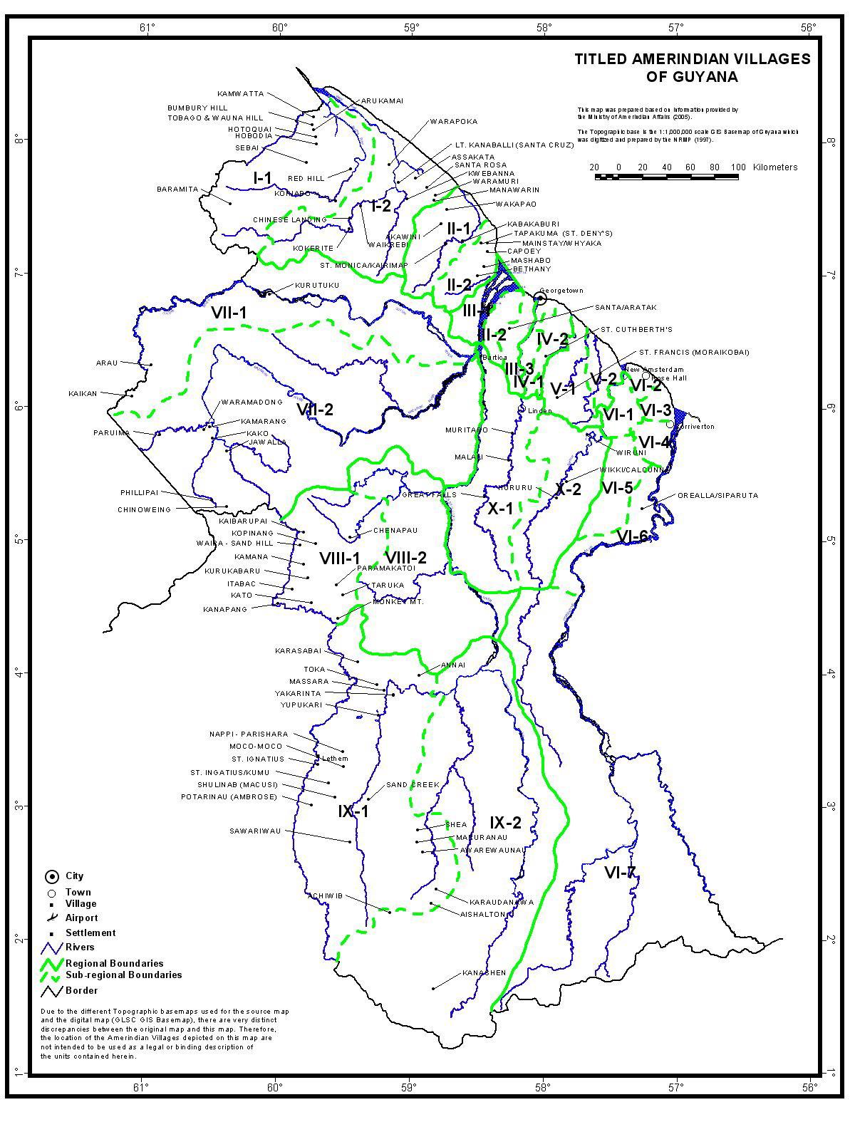
Figure 20. Titled Amerindian Villages in Guyana
Source: Guyana Lands and Surveys Commission, 2006
72
Guyana passed the Iwokrama International Centre for Rain Forest Conservation and
Development Act with the unanimous approval of both sides of the house. The Act was
signed into law on May 12, 1996. Iwokrama has a long standing relationship with the
neighbouring Amerindian communities.
The mission statement of Iwokrama reads:
Promoting the conservation and the sustainable and equitable use of
tropical rain forests in a manner that leads to lasting ecological,
economic, and social benefits to the people of Guyana and to the
world in general, by undertaking research, training, and the
development and dissemination of technologies.
Iwokrama "learns by doing" builds partnerships with local communities and the private
sector. These partnerships combine traditional knowledge, science and business to develop
"green", socially responsible and sustainable forest products and services, like low-impact
timber harvesting, ecotourism, training forest rangers and guides, and the harvesting of
aquarium fish. Businesses provide local and national benefits, and so help maintain
international biodiversity and climate. Iwokrama evaluates the social, economic and
ecological changes that occur as a result of business development. The objective is to become
a model for business development that results in the worldwide conservation of tropical
forests. (Please see www.iwokrama.org for more information on this programme).
5.3.2 Conservation International (Guyana)
Conservation International (CI) has its Mission:
To
biodiversity, and to
demonstrate that human societies are better able to live harmoniously with nature
To promote, assist and
collaborate with the Government of Guyana and other stakeholders towards the
They plan to achieve this goal
through conservation via protected areas. Special emphasis is placed on the: Kanuku
Mountains, Upper Essequibo Conservation Concession (UECC) and the Konashen
Indigenous District protected areas. The efforts on protected areas are coupled with efforts
towards promoting sustainable livelihoods as in the case of supporting the Nappi Balata Craft
Group and partnering with the Government of Guyana (GOG) to assess and promote eco-
tourism.
5.3.3 Guyana Marine Turtle Conservation Society
The Guyana Marine Turtle Conservation Society (GMTCS) is the lead agency in the process
for developing the Shell Beach Protected Area. The GMTCS has five (5) thematic areas of
work: Direct Turtle Conservation, Protected Areas, Education, Research and Community
Development.
5.3.4 Forest Products Association
The Forest Products Association (FPA) of Guyana is non-Governmental Trade Organisation
which was registered on February 4, 1944. The mission of the FPA is to contribute to forest
73
industry development and enhanced competitiveness and growth of the forestry sector in
Guyana through advocacy, training, dissemination of technical, trade and other information,
provision of accessible technical and business support services, by promoting sustainable
practices and by networking with local, regional and international agencies.
Summary
From the wide missions and mandates of the institutions listed above, it is clear that the
ater and soil resources is one that must be shared by
for managing its part of the Amazon includes the visions of all of these entities. The larger
National Vision could therefore be derived from the amalgamation of the individual visions.
6. 0 CONCLUSIONS
Chapter 1
Guyana is the only English speaking country in South America, getting its name from the
Amerindian word translated to land of many waters. The country has six major river
basins: Essequibo, Courentyne, Berbice, Waini, Barima, Demerara and Amacura. In
addition the Takutu River and its tributary the Ireng which form the south-western limits
of the country and flows into the Rio Branco, a tributary flowing into the Rio Negro
which is a confluent of the Amazon River is also an important basin.
The 2002 Population and Housing Census showed that the national population rose to
751,223 and increase of 27,500 from the 1991 census.
The Water and Sewerage Act 2002 paved the way for the development of a national
water policy and the subsequent establishment of water planning mechanism.
With direct reference to water resource management in the Guyana, the NWC as
described in the Water and Sewerage Act 2000, in its constitution alone, strongly
resources has to be a collaborative and integrated effort by all the national institutions
whose mandates impact the country
responsibility of developing, implementing, amending and advising the Minister of
Housing and Water on the NWP.
The NWP, which is developed in consultation with key institutions - the Lands and
Surveys Commission, Hydromet, the Environmental Protection Agency, the Guyana and
Geology and Mines Commission, the Guyana Forestry Commission and the Minister
responsible for Agriculture, any other relevant Government Agency, Local Government
authority including Amerindian Village Councils should ensure that water is equitably
allocated for the social and economic benefits for the people of Guyana.
The Hydrometeorological Service, Ministry of Agriculture operates the National
Meteorological Station Network (NMSN) and the National Hydrological Station Network
(NHSN).
74
water resources is the responsibility of the Hydromet, Ministry of Agriculture. The EPA
through its mandate also has a role to play in the protection and management of the
potable water. The GWI has a key role in assessing the needs of the national population
and ensuring that water is supplied to all communities throughout Guyana. The GWI, by
virtue of being created by the Water and Sewerage Act 2000 works under the policy
supervision of the Minister of Housing and Water.
are the responsibility of the Hydromet. The Hydromet through its role on the NWC can
give a national perspective and recommendations on the state
resources. The NHSN administered by the Hydromet was very comprehensive, but over
the years many of the stations became unserviceable. This could be viewed as a weakness
since data on water flow rates in the various waterways of the country would not have
been collected from these stations. This would impact on the arriving at a better
The fact that the network did exist can be seen as a significant positive however, since a
restored system
foundation and the NWP can be guided accordingly with data generated from this
network. Indeed, the Water and Sewerage Act 2000 expressly states that one of the roles
of the Hydrom
water resources.
The national system should allow for collection of data relevant to: the quantity of water
in the water resources, the seasonal or temporal variations in water resources, the use of
water resources, the rehabilitation of water resources, and the atmospheric conditions
which may influence water resources. The Act also allows for the Hydromet to establish
collaborative efforts of monitoring water resources with other agencies, similar to those
already existing with agencies such as the Guyana Sugar Cooperation, to allow for a
comprehensive data collection system to be in place.
have received limited attention and require more attention. However, the initial national
communication to the UNFCCC has pointed out the impacts climate change would have
on the various natural resource sectors. These recent initiatives aimed at helping the
country to deal with the impacts of climate change namely: Guyana Initial National
Communication: in response to its commitments to the UNFCC and the Guyana Climate
Change Action Plan are important foundations upon which future activities aimed at
dealing with the impacts of global climate change would be built.
There has been a significant amount of work in natural resource planning and planning
-economic development. These include the National Development
Strategy and the Poverty Reduction Strategy Paper. The process for creating a National
75
Protected Areas System has commenced, and efforts are being made to put formal
systems in place for natural resource management on Amerindian lands.
The efforts over the past few months have shown that the major stakeholders in Guyana
with mandates in the natural resource and environmental management sector recognise
that they must pool their efforts if Guyana is going to achieve sustainable development.
Most importantly the impacts of anthropogenic activities were recognised and
acknowledged.
Capacity building for the adaptation to climate change has been identified as a critical
area and has received a considerable amount of attention.
Anthropogenic activities, if not closely monitored can have significant and irreversible
Basin.
The interconnectivity of the area s hydrology needs some further attention, as the recent
Rio Branco a
suggested.
Chapter 2
The future scenarios for water management in Guyana would be built on the current
situation for water, environmental, and natural resource management. At the beginning of
the process the scenarios were pessimistic, realistic and optimistic in nature, however, at
the conclusion of the process it seemed more feasible to craft probabilistic position based
on current trends. The current trends indicated that there is some efforts make sustainable
efforts a core theme of resource extraction efforts in Guyana. However, there are areas of
concern, for instance legislation aimed at sustainable resource extraction (Water and
Sewerage Act 2002, but such legislation are not adequately implemented.
If the current trend continues, in the next five years, serious impacts on the environment,
including environmental degradation could begin to occur. This would probably lead to
efforts at becoming more efficient in resource extraction in the medium term. This era
might also see the introduction of more research into resource extraction especially water,
to ensure that water utilisation is more efficient than current trends. In the long term, the
increasing population could see more emphasis on the country
The national population could become more aware and attempt to play a greater role in
determining how their resources are utilised.
The discussions that lead to the development of the future scenarios highlighted to a great
extent the activities that could be conflicting with respect to sustainable management of
attention and planning. Clearly these activities have a role to play in the national
economy, but their operations should be governed by strong codes of practice to ensure
that future generations of Guyanese could benefit from their extraction as well.
76
Chapter 3
Given that the eight countries of the Amazon Basin have similar areas of interest, there
are going to be areas that would have to be addressed by all the countries. In the final
analysis, the success of the sustainable management of the
resources would
depend largely upon how well the eight states can harmonise their efforts and work
towards common goals. Collaboration at the national level would have to take into
consideration national priorities and realities and would depend largely upon the
harmonization of efforts at the national level. However, even though the momentum for
achieving sustainable development must be created at the national level, this momentum
must be based on sound inputs from the widest possible crossection of stakeholders who
must be involved in the process.
The main issues that came to the fore for the consideration by all eight states of ACTO
were: Global Climate Change, Population Growth/Transient Population, Health,
Sedimentation and Pollution, Deforestation, Water Resource Use, Illegal Activities
including fishing, wildlife, and intellectual property rights, energy navigation and
investigation of transboundary off-site effects.
Kanuku Mountains, Mount Roraima, Shell Beach, South-Eastern Forest, Kaieteur
National Park, Rupununi Wetlands, and Amerindian Communities were identified as hot
spots.
strongly suggests that the country would like to strive towards sustainability. There is
tremendous potential for the country to achieve this goal, as its intact resources and
ecosystems present a realistic opportunity.
The efforts over the past few months have shown that the major stakeholders in Guyana
with mandates in the natural resource and environmental management sector recognise
that they must pool their efforts if Guyana is going to address its sustainable development
natural capital, exploitation needs to be done in a sustainable manner. There have already
been efforts endorsing this position, for instance, through the NDS and the PRSP, the
National Biodiversity Action Plan, the Forestry Code of Practice and the Environmental
Protection Act, but to name a few.
Capacity building for the adaptation to climate change has been identified as a critical
area and has received a considerable amount of attention. A number of Guyanese
nationals have been trained or are receiving training in Climate Change at the University
of the West Indies. It is hoped that once these persons would have received their training,
they would return to share their expertise in allowing the country to be able to deal with
the impacts of climate change. Anthropogenic activities, if not closely monitored can
, the
water resources of the Amazon Basin. The interconnectivity of the area s hydrology
needs some further attenti
Rio Branco and the
77
Chapter 4
However, the economic conditions of the country could change this situation. An increase
in per capita income for the national population would mean most likely translate to more
sophistication and an increased demand for fresh water for basic urban functions.
Interestingly, increased agricultural production and industrialization are likely to be the
key drivers for improving economic fortunes. Increased agricultural production would
require irrigation systems, thereby removing water that was previously dedicated for
environmental purposes being transferred to satisfy agricultural demand. The difficulty in
these changing water uses would of course be in tracking how water from one area of use
is being transferred to another area.
When the strengths, weaknesses, opportunities and threats in the development of
environmental management are examined, it is clear that there are some very relevant
legislation and policies that once implemented, could be significant in terms of charting
the course towards sustainable development. However, the challenge with these is that
they are not being adequately implemented.
Similarly there are some significant threats, for instance, low coastal topography that if
not properly managed could lead to significant catastrophes. Should the coastal sea
defence mechanisms fail, large portions of the coast would be threatened, including
biodiversity, settlements and coastal aquifers. Such an event would possibly push the
coastal population inland, placing pressure on the biodiversity of the highland regions.
From the stakeholder consultations it was evident that much of the effort for the future in
terms of development and natural resource utilisation would aim to build around the
principles of sustainability. However, it is clearly recognised that balancing
anthropogenic activities and environmental protection would be the greatest challenge.
7. 0 RECOMMENDATIONS
1. The success of a regional (ACTO) programme to sustainably manage transboundary
water resources would depend largely upon the strength of the individual countries
making up the regional entity to successfully manage and implement programmes to
In Guyana the Water and Sewerage Act 2002, sets a good foundation for Guyana to
sustainably manage its water resources
plan is implementing the Act. The institutions that should play a critical role in shaping
the National Water Policy need to be strengthened or at the least take some steps to
advance their obligations as mandated by law. If these institutions are given the support
and latitude they need to implement and make the legislation functional, then it would
78
become easier for Guyana to make its contribution towards sustainably managing the
es.
Institutional strengthening should include empowering the Hydrometeorological Service
with financial and human resources as well as physical infrastructure to perform the role
effectively.
lso be of significant benefit if the
and are harmonised to the
best extent possible to ensure that programmes for resource protection and management
are parallel to each from one state to another.
2. The existence of the Water and Sewerage Act 2002 is an important step towards the
,
it was clear that there is a strong understanding of the requirements of the Act. However,
it was obvious that the Act was not being implemented in the way it should to bring
sustainable benefits to the Guyanese people. It would seem extremely beneficial and
certainly go a long way towards sustainable water management if the national population
was aware of the legislation and its intended impacts on their livelihood. Some efforts
should therefore be made in a public awareness programme to make the national
population aware of the legislation, its intended impacts and the role they can play in
making its implementation a reality.
Such an awareness programme should be led by the Hydrometeorological Service with
support from the Ministry of Housing and Water and could include broadcast pieces in
the electronic media, workshops and seminars throughout the ten administrative regions
of Guyana. It could also include a school - based (primary, secondary, tertiary,
vocational) programme to give young people and school children an opportunity to
understand the legislation and the role they can play in its implementation and as an
The awareness programme should also include details on the fact that Guyana is a part of
the Amazon Cooperation Treaty Organisation and the implications of this fact on the
lives of each and every Guyanese. The success and failure of future efforts aimed at
region understand their wider ecosystem and how their lives would be impacted if they
did not take care of it.
3. Some effort and emphasis should be placed upon trying to get a better understanding of
the climate change that may be occurring in Guyana. Such research should be led by the
s with support from the Hydrometeorological Service. It was
clearly recognised that sound decision making in the future must be based on the results
of strategic research activities and that such research should be based on strong scientific
practices, including precise and accurate data collection.
79
4. There is an urgent need for the harmonization of legislation for forest extraction and
mining in the region and efforts should be pursued to immediately address this situation.
At the earliest possible opportunity, regional policy makers should meet and compare
standards, and with due consideration for their economic realities attempt to at least have
their codes of practice meet an established minimum.
5. More research needs to be undertaken to determine the extent of impacts on the regions
fresh water resources from anthropogenic activities such as mining and forestry.
6. The networks for hydrological and meteorological monitoring needs to be improved to
allow for a comprehensive understanding of the impacts of climate variability of the
regions fresh water resources. Implementing programmes for achieving a more
comprehensive monitoring coverage must attempt to have as much as possible a bottom
up approach with local people and communities playing a significant role in monitoring
activities. Such involvement of local people would allow communities and people to own
the process and better understand the impacts of activities within the region on climate
variability.
7. There needs to be more studies aimed at understanding the linkages and connections
between the regions hydrological system. Such an understand would allow for each
country to better understand its role and responsibility for safeguarding the welfare of
common resources.
8. There needs to be more studies to establish the changes in water use that may occur as a
result of water being shifted from one use scenario to another. This is particularly
important for water moving from environmental uses to water being used for urban
purposes.
9. With respect to the issues of transboundary interest, the following are recommended:
a. Global Climate Change:
Greater collaboration between the countries comprising the ACTO to ensure
that there a uniform system for tracking climate change and improving the
understanding the impacts of climate change at the regional, national and local
levels e.g. understanding the impacts of climate change and sea level rise on
coastal Guyana, Suriname, Ecuador and Venezuela;
Once the impacts of climate change are understood, develop strategies for
dealing with these impacts, for instance in Guyana once the impacts of climate
change on the coast are that significant, then this country would need to
consider measures for relocating coastal population to inland Guyana;
Carry out studies to improve the understanding of the historic variability of
the hydrological variables aiming at the forecast of the water availability;
80
Assess the impact of climate variability on the energy sector in the Amazon
Region;
Improve long-term forecast with the goal of reducing the impact of the climate
variability risk: verify the long-term forecast for the agriculture and energy
sectors through a regional pilot project;
Embark on a widespread programme for improving local people and local
communities understanding of climate variability and including these
stakeholders in assessing climate change and its impacts.
b. Population Growth/Transient Population:
More widespread education of national populations on their responsibilities
with respect to water management, inclu
water resources are under threat and must be appropriately managed
regardless of which country one may be in at a particular point in time;
Develop better systems for determining supply and demand and determining
the most efficient manner of meeting demand at the national then regional
levels so that water supply could be appropriately scaled to meet increasing
human population;
Improved management and monitoring of the regional ecological systems to
ensure that there sound understanding of water sources in the regional and the
integrity of these are not compromised as population grows and the need for
access to new agricultural lands for food production become necessary;
Ensure that there are designated fresh water resource use zones throughout the
Amazon region, and that these resources are managed in a sustainable manner.
c. Health:
Develop an integrated system for understanding the impacts of climate
variability on the life cycle of vectors of water borne diseases;
Develop an integrated regional system for sharing knowledge on dealing with
water borne diseases and responding to emergency situations;
Ensure that water is treated properly to remove pathogens of water borne
diseased before delivery to the final users and put in place a comprehensive
system for ensuring that activities that would lead to the prevalence of water
borne diseases are properly regulated.
d. Sedimentation and Pollution:
Building the capacity of miners, foresters, farmers and other stakeholders
whose activities could result in sedimentation and pollution of water ways so
that they are made aware of the detrimental effects of their activities on the
regional water resources in light of a resources availability challenge;
Better application and compliance with national, international standards and
codes of practice that determine the manner in which forestry and agricultural
activities should be conducted to minimise impacts on the environment, with
specific reference to fresh water resources;
81
Ensure that there is appropriate waste and pollution source management
system in place. Ideally, this system should aim to tackle the problem from the
should be reduced in use as these have the greatest impact on blocking and
polluting water ways.
e. Deforestation:
Forestry activities better comply with national standards and activities of a
developmental nature throughout the region made to comply with
international conventions such as the United Nations Convention on
Desertification;
Design regional pilot projects for replanting areas deforested during mining,
forestry and agricultural activities. Once these are successful, methodology
and lessons learnt are used in the designing other such projects/programmes
throughout the region.
f. Water Resources Use:
Invest in renewable sources of energy for generating power for running water
treatment and delivery plants thereby reducing the cost of delivering safe
water to customers;
Carry out studies to determine the change in demand on water resources
brought about by these new water uses. Studies should aim to determine
exactly what amount of water is moved from environmental purposes to other
uses so as to determine changes in water use and the responsible sector.
g. Illegal activities including: fishing, wildlife, intellectual property rights:
Develop regional regulatory mechanisms for wildlife trade, fishing,
intellectual property rights. Once developed these regulations should be
enforced with similar weight throughout the region;
Design public awareness campaigns to educate the regional population on the
state of regional wildlife populations and their responsibilities for ensuring
that the status of these populations are not further compromised as a result of
their activities.
h. Energy:
Develop regional programmes and strategies for understanding and
developing renewable sources of energy such as hydro, solar, wind and
geothermal as the primary source of energy in the region;
Develop pilot projects throughout the region to demonstrate the development
of renewable energy project and sharing lessons learnt throughout the region.
i. Navigation
Develop a regional code of practice for navigation throughout the region. The
code should include territorial immigration and police organisations in the
82
respective states so as to have total involvement from these entities thereby
improving the chances of reducing the trade in threatened and endangered
species as well as protecting the integrity of regional water ways and
ecosystem;
There should also be a regional code for materials that can be transported
hazardous and materials that can have detrimental impacts on water ways
from being transported in navigation routes.
j. Investigate transboundary off-site effects
Carry out regional studies to determine the interconnectivity of regional water
bodies;
Carry out regional studies to understand the impacts of activities such as
overfishing in one state on the fishery of another state;
Develop a regional strategy for dealing with interconnected water bodies
throughout the region so as to safeguard the integrity of these important
ecosystems.
10. There needs to be additional national and regional awareness programmes on the
activities and objectives of ACTO. Such activities should aim to captured the
attention of a wide crossection of the regional population as possible so that they are
aware of the activities of ACTO. Such initiatives would allow for support for the
programme from the very foundations of the regional community.
8.0 DEMONSTRATION PROJECTS
This section gives three proposal for the development of demonstration projects in Guyana.
the first project has been deemed as a top priority by the Hydrometeorological Service,
Ministry of Agriculture and as such was developed in greater detail than the other two.
Therefore the other two are only stated here as ideas, and would require further development.
1. Strengthening the capacity of Hydrological and Meteorological monitoring
networks as a means of tracking climate change and sea level rise.
Justification:
National Hydrological Stations Network (NHSN) is currently
performing well below its required capacity, both in terms of infrastructure and human
comprehensive network of Hydrological Stations strategically distributed throughout the
country. Over the years most of these stations have become unserviceable resulting in a
hydrology and meteorology conditions. The result is that data collection being carried out
83
by the Hydrometeorological Service does not allow for a comprehensive understanding
This is even more critical when it is considered that data collection by the Service is
important for meeting its mandate, which include:
Assessment of Guyana's water quality and quantity, for example, for irrigation
Water distribution in time and space
Potential for water related development such as hydropower
Assessing the environmental and socio-economic impacts of different water related
practices, for example, gold and silver mining
Assessing the impacts of other sectors on the country's water resources such as
lumbering and deforestation
Flood and drought forecasting, especially since the Coastal Plain is a flood risk from
both the Atlantic and the East Demerara Water Conservancy (EDWC).
These applications of hydrological data, which would include monitoring for changes in
water quality as a result of sea level rise, are no doubt sufficient to justify why an
equipped and highly functional hydrological network is essential for the success of
Guyana's people and the country's competitiveness from a global perspective.
Further, and most importantly, the development of a comprehensive system for monitoring
climate and hydrological variables at the national level would also have global significance.
This is particularly so as it would allow for comparative analysis of climate variability to be
observed between Guyana and its neighbours. Given that Guyana is primarily a coastal state,
understanding the impacts of cl
benefit countries with similar geographic orientations as Guyana.
Objective: The objectives of this two-year effort are to strengthen the National Hydrological
Stations Network (NHSN) and the Nation Meteorological Stations Network (NMSN):
- To serve to collect reli
s hydrology
and meteorology
- To be able to track global climate change and sea level rise to serve as a
global model, tracking lessons learnt for application in countries with similar
geographic orientation as Guyana.
- To involve stakeholders in monitoring national climate thereby allowing them
to better appreciate climate variability in the long term and serving as a global
model demonstrating how local people and communities could be involved in
Implementation Partners: The project would be implemented with lead from the
Hydrometeorological Service, Ministry of Agriculture in collaboration with National
A
, Conservation International and the Guyana
Marine Turtle Conservation Society and communities. Funding for project implementation
would be so
Organisation.
84
Areas of Focus: The project would seek to relocate the position of currently unserviceable
Hydrometeorological and Meteorological Stations and assess how these can be brought back
to full serviceability. An assessment of the parameters being monitored by each of these
stations would be done to ensure that the system is assessing the widest and most relevant
provides comprehensive coverage of the coastal plane will allow for possible changes in sea
level and its impacts to be readily observed and recorded including impacts on coastal
aquifers.
Current Challenges:
Network: A recent World Meteorological Network study has shown that there are currently
seventeen hydrological stations in operation, when the network should comprise a minimum
of seventy stations.
Staffing: In the Surface Water Section of the Service, the staff complement can be
summarised as follows:
Area of Specialisation
Post (s)
Vacancies
Specialist Hydrologist 2
2
Hydrologist
2
2
Hydrological Superintendent
1
-
Hydrological Officer
1
-
Senior Hydrological Technician
3
3
Hydrological Technician II
3
3
Hydrological Technician I
9
7
Hydrometeorological Technical Assistant
9
3
Total 30
22
Funding: The establishment of a comprehensive hydrological network would require a
significant amount of funding. The estimated cost for the establishing a hydrological network
that meets the minimal requirements as prescribed by the World Meteorological Organisation
is given below, described in two phases: short term and long term.
SHORT-TERM ( 35
LONG TERM (25
stations)
stations)
ITEMS
Cost ($US)
Cost ($US)
Materials $45,500
$68,250
Transportation of material
$3,500
$5,250
Labour $37,450
$56,175
Instrument $122,500
$183,750
Transportation for technician $17,500
$26,250
$226,450 $339,675
85
Proposed Objectives, Activities and Outputs
Objective One: Assess Hydrological Network
Activities:
1. Comprehensive assessment of the previous hydrological network to determine the
location and spatial coverage of the current hydrological network.
2. Review of literature to determine the location of unserviceable hydrological stations
3. Assessment to determine whether some of the unserviceable hydrological stations could
water basins.
4. Identification of parameters to be monitored by each station in accordance with the
WMO and in keeping with ACTO standards
Outputs:
1. Map and description of the current hydrological network, and description of the spatial
coverage by the current network
2. Map showing the location of unserviceable hydrological stations and description of the
stations to be restored to full serviceability and parameters to be monitored at each station
Objective Two: Install additional hydrological stations and develop data collection and
analysis protocol
Additional hydrological stations installed and data collection and analysis protocol
Activities:
1. Installation of additional hydrological stations in accordance with guidance from WMO
and ACTO requirements
2. Data collection and development of analysis protocol to be shared with potential partners
Outputs:
1. Installation of hydrological stations in strategic locations of Guyana
2. Data collection and development of analysis protocol to be shared with potential partners
Objective Three: Establish collaborative agreements between Hydrometeorological Service
and other agencies, NGOs and local communities for hydrological data collection
communities completed and p
Activities:
1. Completion of formal collaborative arrangements for hydrological monitoring between
Hydromet and other agencies, NGOs and local communities
86
2. Sharing of protocol for data collection shared with partners and discussion of necessary
capacity building issues
Outputs:
1. Completion of collaborative data collection agreements
2. Completion of relevant capacity building to allow for effective and efficient data
collection with partners
3. The involvement of local people and communities in collecting, analyzing and
interpreting hydrological and climatological data
4. Models of local people involvement documented and lessons learnt shared with other
ACTO states and the global community
2. Coastal Forest Resuscitation and Replanting
Justification:
Coastal Plane is extremely vulnerable to the threats of global
warming and sea level rise. Historically,
mangroves and coastal vegetation that served to keep out the harmful waves from the Coast
thereby preventing flooding. In addition to decapitating waves arriving at the Coast,
mangroves also serve the critical function of filtering runoff to the sea and serve as habitats
for many forms of aquatic and terrestrial wildlife.
Over the years, this layer of mangrove has been removed mainly for fuel wood, to the extent
end result is increased pressure on the man-made sea defence structure to prevent waves and
sea water from reaching land. These man-made structures often fail leading to flooding and
intrusion of coastal freshwater systems by saline water. In general, coastal Guyana has
become more vulnerable to flooding and the intrusion of coastal aquifers by saline water is
now a very realistic threat.
87
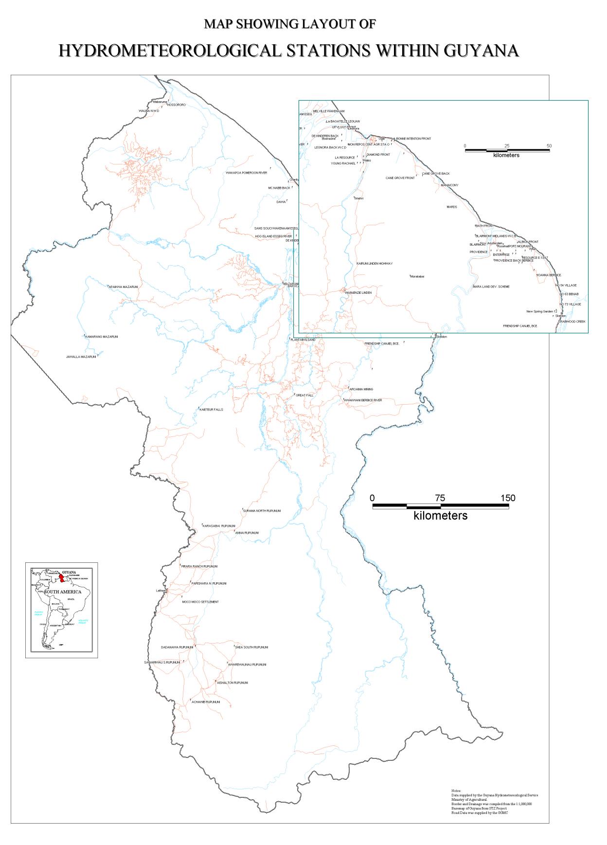
Figure 1: Map of Guyana showing the current Hydrometeorological Network
88
An effort to replant or resuscitate the mangroves on the coastal zone could serve to
strengthen the coastal defence structure of the system as well as providing a habitat for
various forms of biodiversity. A properly managed system can also bring sustainable benefits
of costal ecotourism.
3. Develop National System for Emissions Trading: Greenhouse Gas Emissions
Trading
or assets is its bountiful forest cover. Close to seventy-five percent of
the country is covered in forest. It is widely established that forests trap greenhouse gases,
and can therefore play a critical role in emissions trading regime for instance those proposed
by the Kyoto Protocol. This initiative is suggesting that a National System Emissions
Trading: Greenhouse Gas Emissions Trading should be developed for Guyana. This process
would allow interested local companies to purchase carbon credits from the state and private
entities such as Amerindian communities to ensure that their respective companies are
engaging in businesses that are environmentally and socially responsible.
89
9.0 SELECTED BIBLIOGRAPHICAL REFERENCES
1. By-Laws for the Management of Natural Resources by the Communities of the North
Rupununi, November, 2005, Ministry of Amerindian Affairs, Thomas and Quamina
Street, Georgetown, Guyana.
2. Environmental Protection Agency Act, 1996
3. Eva, H.D. and O. Huber (editors), 2005, A Proposal for Defining the Geographical
Boundaries of Amazonia, Synthesis of the results from an Expert Consultation
Workshop organized by the European Commission in collaboration with the Amazon
Cooperation Treaty Organization - JRC Ispra, 7-8 June 2005, European Commission.
4. Guyana Climate Change Action Plan, 2002, In Response to its Commitments to the
UNFCC
5. Guyana Forestry Commission Act, 1979
6. Guyana Forestry Commission, 2004, Guyana Woods: 21 Species , Guyana Forestry
Commission, 1 Water Street, Kingston, Georgetown, Guyana
7. Guyana Geology and Mines Commission Act, 1979
8. Guyana Geology and Mines Commission, 2005, Guyana, South America Mineral
Investment Opportunities, Upper Brickdam, Georgetown, Guyana.
9. Guyana Geology and Mines Commission, 2005, The Mining Sector in Guyana,
Guyana Geology and Mines Commission, Upper Brickdam, Georgetown, Guyana
10. Guyana Lands and Surveys Commission Act, 1999
11. Guyana Water Incorporated, 2005, Hinterland Report and Strategy, Guyana Water
Incorporated, Fort Street, Kingston, Georgetown, Guyana
12. Mott McDonald, 2004, Hydrology and Water Resources Final Report, Guyana
Drainage and Irrigation Systems Rehabilitation Project, Ministry of Agriculture,
Guyana
13. National Development Strategy, 2000, A Policy Framework: 2001-2010, Eradicating
Poverty and Unifying Guyana, A Civil Society Document
14. Persaud, C. and K. Persaud, 1995, The Classification of Rainfall Regions of
Guyana, Caribbean Climate Centre- Caribbean Meteorological Institute, Climate
Related Science Series No.4.
15. Poverty Reduction Strategy Paper, 2005, http://www.povertyreduction.gov.gy/
16. Seulall, B.D., 2005, Variability and Trends of Daily Rainfall and Temperature
Extreme in Coastal Guyana, Master of Science degree Dissertation, Weather and
Climate Modelling, Department of Meteorology, University of Reading
17. Water and Sewerage Act, 2000
18. Guyana National Communication in Response to it Commitments to the UNFCC,
2002.
From Internet:
1. www.forestry.gov.gy
2. www.si.edu
3. http://www.sdnp.org.gy/csbd
4. www.epaguyana.org
5. www.iwokrama.org
6. http://www.povertyreduction.gov.gy/index.html
7. http://www.sdnp.org.gy/gea
90
8. www.agrinet.com/lands
9. www.ggmc.gov.gy
10. www.guyanaclimate.org
91
10 ANNEXES
This space is deliberately left blank.
92
NTS
COMME
,
,
W
W
W
HIC
E
, SE
, S
, NW
SW
RAP
, SE, N
, 5
E, 69 S
SW
75 NW
SHEETS
1 SW
68 NE, SW
TOPOG
4 SE, SW
9 NE, 10 NW
68 NE, SE, 69 N
68 SE, N
UDE
-06"
-50"
-30"
-24"
-18"
-30"
-37"
-29"
-29"
-40'
-11'
-08'
-03'
-57'
-46'
-36'
-39'
-36'
0
0
0
0
0
0
0
0
0
59
60
60
60
59
59
57
57
57
DINATES
COOR
-08'-57"
-04'-30"
-55'-06"
-37'-06"
-18'-58"
-15'-00"
-18'-04"
-19'-06"
0
-07'-35"
8
0
8
0
7
0
7
0
7
0
6
0
3
0
3
0
LATITUDE LONGIT
36
93
S
(AV
MW
MW
MW
.01
4
6
.01 MW
7 MW
65 MW
107 MW
ENERGY)
.015 MW
.005 MW
POWER
CONTINUOU
RS
N
RIVE
ARUNA
ARUKA
KARIABO
BARIMA
BARAMA
BROW
LOO CREEK
NEW RIVER
NEW RIVER
BARRINGTON
N
Hydropower sites in Guyana
NIL
NIL
NIL
N FALLS
SITES
MAURU
DINDYAL
BROW
AMARIPA
NAMES OF
HOSSORORO
LOO CREEK
ECLIPSE FALLS
TOWAKAIMA
BARRINGTON
BARRINGTON
BROW
1
2
3
4
5
6
Annex 1: Potential
REGION
1
2
3
4
5
6
7
8
9
REF
NO.
til
un
eriod of
this
ies on
of
y
ENMAN
ants the
e
ar p
gr
stud
y
t 15, 2003
ment and the
Alleviation
d of US based
ned a
the stud
.
, which
to carr
of this site.
ts a two-y
for
Govern
eriod of exclusivity
, 2005
a
na Poverty
a
nese
31
e
asibility
y
y
y
Memorandum of Understanding
signed on Augus
between
Gu
Group, comprise
Gu
which gran
exclusivity
site.
Government sig
Memorandum of Understanding
with a Trinidadian firm
Services Ltd
firm a p
Jul
the f
,
W
, 36,
, SE
, SE
, SW
, SW
, 27 SW
, 19 SW
, 33 NE,
, SE, SW
, SE, SW
, SW
, SE, SW
E, 28 S
N
NE,
NW
SE
, SE, NE, SW
42 NE
, SW
, NE, SW
, SW
27 SE,
27 NE, NW
26 NE, NW
35 NE, NW
34 NE, NW
34 NW
36 NW
27 NE, SE, SW
27 NE, NW
27 NE, NW
27 NE, NW
17 NW
34 NW
-11"
-00"
-58"
-55"
-30"
-40"
-49"
-40"
-15"
-45"
-06"
-14"
-17"
-04"
-44'
-45'
-36'
-34'
-46'
-43'
-49'
-43'
-27'
-48'
-51'
-19'
-46'
-56'
0
0
0
0
0
0
0
0
0
0
0
0
0
0
59
59
59
58
59
58
58
58
59
58
58
59
59
59
-00"
-29'-34"
-
45'
-43'-35"
-06'-41"
-15'-00"
-12'-34"
-15'-49"
-19'-20"
-11'-45"
-29'-21"
-28'-28"
-20'-11"
-49'-06"
-49'-59"
5
0
5
0
5
0
6
0
6
0
6
0
6
0
6
0
6
0
6
0
6
0
6
0
6
0
5
0
94
MW
MW
MW
MW
MW
7 MW
6
40 MW
6
120
0.7 MW
0.1 MW
320 MW
.025 MW
103 MW
162 MW
13
62
SABREK
KABURI
TEPURU
CUYUNI
CUYUNI
PURUNI
MERUME
MAZARUNI
ESSEQUIBO
IKURIBISI
MAZARUNI
WINEPERU
MARAPAIKRU
CUYUNI
A
SABREK
SEMANG
TIBOKU
KABURI
ARISARU
PURUNI
IKURIBISI
TEPERU
CHI-CHI
TURTRUBA
WINEPERU
KAMARI
OKO BLUE
DIVERSION TO
MERUME RIVER
7
10
11
12
13
14
15
16
17
18
19
20
21
22
23
ned a
hich
f
006
w
til
r
iod o
un
Government sig
Memorandum of
Understanding with
two Japanese
organizations,
grants a pe
exclusivity
November 15, 2
for
studies on the site.
,
,
W
, SE
, SE
E
, 34
, 33
, SE
W
E
E
, 14
, 14
, 23
, S
, SW
, SW
E
, SE
, SE
, NE
, SE, SW
32 NE,
, SE
, SE
, SE
NE
E, 32 S
SW
, SW
NW
E, 32 N
NW
SE
SE
SE
NW
SE
, NW
, NE, SW
, SW
, 15 NW
, SW
, SW
, 15 NW
31 SE, N
31 NE, NW
15 NW
33 NE, SE, SW
23 SE, 32
24 SW
31 SE, N
24 NE, NW
24 NW
23 NE, SE, 24 N
31 NE, SW
15 NW
15 NW
15 NW
23 NE, SE, 32 N
23 SE, N
23 NW
23 NW
-44"
-36"
-17"
-26"
-32"
-54"
-51"
-44"
-33"
-14"
-56"
-48"
-39"
-11"
-07"
-09"
-48"
-38"
-13'
-20'
-24'
-22'
-35'
-36'
-37'
-39'
-03'
-07'
-10'
-02'
-50'
-50'
-50'
-51'
-39'
-49'
0
0
0
0
0
0
0
0
0
0
0
0
0
0
0
0
0
0
60
60
60
60
60
60
60
60
61
61
61
61
60
60
60
60
60
60
-14"
-20"
-42"
-17"
-15"
-13"
-41"
-28"
-09"
-25"
-14"
-48"
-47"
-43"
-40"
-10"
-55"
-38"
-34'
-08'
-16'
-21'
-23'
-18'
-11'
-00'
-36'
-41'
-46'
-47'
-40'
-37'
-28'
-34'
-31'
-25'
5
0
6
0
6
0
6
0
6
0
6
0
6
0
6
0
5
0
5
0
5
0
5
0
6
0
6
0
6
0
6
0
6
0
6
0
95
MW
MW
MW
MW
96 MW
86
34
19
38 MW
31 MW
14 MW
13 MW
17 MW
26 MW
1 MW
20 MW
1 MW
5 MW
17 MW
6 MW
1320 MW
650
ZARUNI
UTSHI
MERUME
MAURU
EKREKU
EKREKU
EKREKU
EKREKU
EKREKU
EKREKU
MAZARUNI
KURUPUNG
MAZARUNI
MAZARUNI
MAZARUNI
MAZARUNI
MA
KAMARANG
KAMARANG
G
N
A
K
CHI-CHI
PEAIMA
UTSHI
ARUWAI
KUMARAU
APAIKWA
PARUIMA
SAKAI
1 DAM MAURU
CHITIGOKENG
5 DAM EKREKU
4 DAM EKREKU
2 DAM EKREKU
3 DAM EKREKU
1 DAM EKREKU
SAND LANDI
O
GREAT FALLS
O
O
O
O
O
UPPER MAZARUNI
N
N
N
N
N
N
DIVERSION SCHEME
7
24
25
26
27
28
29
30
31
32
33
34
35
36
37
38
39
40
41
this
a
y
of
the
.
ice b
tudy
.
droelectric
y
y
Holdings and
jointly
h
y
t of serv
e
rg
n
MW
e
veloped
y
ational
the vicinit
feasibility s
been
t
d
to S
ernment owns and
as been completed and an
This site, which is one of
protected area.
A detailed
site h
Interim Licence to develop
project has
granted
Harza Intern
The gov
operates a 0.5
power plan
at this site. Recently that power
plant was put ou
landslide in
,
,
W
, 35
, SE
, SE
, SE
, NW
, NW
, SE, SW
, SE, SW
, SE, SW
, SE, SW
, 15 SW
, SW
, SW
, SW
SW
SW
SW
SW
23 NW
42 NW
42 NW
42 NW
42 SE, 43
42 NE, 43 NW
43 NE, NW
43 NE, 44 NE
43 NE, SE, 44 N
64 NE, NW
64 NE, NW
64 NE, NW
-06"
-20"
-36"
-20"
-08"
-29"
-19"
-30"
-32"
-01"
-50"
-18"
-00"
-50"
-04"
-51'
-53'
-40'
-38'
-29'
-33'
-15'
-56'
-00'
-01'
-09'
-08'
-45'
-46'
-48'
0
0
0
0
0
0
0
0
0
0
0
0
0
0
0
60
59
59
59
59
59
59
60
59
59
60
60
59
59
59
-14"
-00"
-43"
-59"
-49"
-05"
-38"
-50"
-46"
-21"
-45"
-00"
-41"
-48"
-09"
-22'
-19'
-04'
-01'
-08'
-21'
-19'
-18'
-21'
-14'
-41'
-39'
-21'
-17'
-21'
6
0
5
0
5
0
5
0
5
0
5
0
5
0
5
0
5
0
5
0
4
0
4
0
3
0
3
0
2
0
96
MW
MW
MW
MW
MW
5
13 MW
77 MW
6 MW
216 MW
103 MW
29
.05
34 MW
.01 MW
.3 MW
0.1
0.1
0.1 MW
KUMA
EKREKU
POTARO
POTARO
POTARO
POTARO
POTARO
POTARO
CHIUNG
CHIUNG
COZIER
KURIBRONG
KONAWAK
KONAWARUK
MOCO-MOCO
RO
KATO
CHI-CHI
RIVER
IATUK
ITABU
KUMA
AMAILA
QUEEN
COZIER
KAIETEUR
DIAMOND
AIKWADUIK
DIVERSION
KONAWAK
AKOBENANG
MOCO-MOCO
TO THE POTA
TUMATUMARI
KURUKABARU
8
42
43
44
45
46
47
48
49
50
51
52
53
54
55
56
te but
eriod of
p
looded
this si
y
shows that a
okrama
anted a
ud
gr
tudy
y
to st
s
y
the Iw
Development.
The Trinidadian firm ENMAN
was initiall
exclusivity
preliminar
vast area would have f
including
Rainforest
,
,
W
W
, 44
W
, N
, N
, SE, SW
, SE, SW
, SE, SW
, SE, SW
, SE, SW
, SE
, SE, SW
, SE, SW
NE
NE
E, 28 S
SW
SW
, SW
SW
64 SE, 65
64 SE, 65
27 SE, N
66 NE, NW
67 NE, NW
67 NE, NW
67 NE, NW
66 NE, NW
51 NW
37 NE, NW
52 NE, NW
-33"
-31"
-00"
-23"
-21"
-20"
-03"
-00"
-00"
-26"
-56"
-22'
-17'
-44'
-17'
-14'
-15'
-17'
-51'
-31'
-22'
-13'
0
0
0
0
0
0
0
0
0
0
0
59
59
58
58
58
58
58
58
58
58
58
-53"
-26"
-30"
-17"
-50"
-55"
-38"
-28"
-03"
-57"
-51"
-23'
-19'
-15'
-08'
-16'
-18'
-32'
-58'
-00'
-38'
-53'
3
0
3
0
3
0
3
0
3
0
3
0
3
0
4
0
6
0
5
0
4
0
97
MW
MW
MW
2 MW
4 MW
8 MW
6 MW
112 MW
63 MW
12
10
346
0.1 MW
15 MW
REWA
MAPARRI
ANARIKA
BERBICE
WAMAKARU
ESSEQUIBO
ESSEQUIBO
ESSEQUIBO
ESSEQUIBO
ESSEQUIBO
DEMERARA
ARI
IV
REWA
MAPARRI
ITABRU
TAKW
ANARIKA
WAMAKARU
MANAROWA
PATTERSON
TIGER HILL
KING GEORGE V
KING WILLIAM
9
10
57
58
59
60
61
62
63
64
65
66
67
Annex 2: List of Active Hydrometric Stations throughout the Ten Regions of Guyana
LON-
LON-
LAT-
LAT-
STATION NAME
DISTR
ICT
Degrees
Minutes
Degrees
Minutes
MABARUMA N.W.D.
Region
I
59
47
8 12
WAUNA N W D
Region
I
59
51
8 8
ANNA REGINA
Region
II
58
28
7 15
CAPOEY COMPOUND
Region
II
58
29
7 12
CHARITY POMEROON
Region
II
58
35
7 23
DAWA Region
II
58
36
7 12
MC NABB BACK
Region
II
58
33
7 20
ONDERNEEMING ESSEQUIBO
Region
II
58
28
7 6
WAKAPOA POMEROON RIVER
Region
II
59
45
7 35
La BAGATELLE LEGUAN
Region
III
58
24
6 54
BOERASIRIE W.C.D
Region
III
58
21
6 49
DE.KINDEREN BACK W.C.D Region
III
58
19
6 50
DE KINDEREN FRONT W.C.D Region
III
58
20
6 52
FORT ISLAND ESSEQ RIVER
Region
III
58
30
6 47
HOG ISLAND ESSEQ RIVER
Region
III
58
31
6 52
LA RESOURCE W.B.D
Region
III
58
14
6 43
LEONORA BACK.W.C.D
Region
III
58
17
6 47
LEONORA CORNER W.C.D
Region
III
58
17
6
47
LEONORA FRONT.W.C.D
Region
III
58
17
6 52
MELVILLE WAKENAAM
Region
III
58
28
6 57
UITVLUGT BACK.W.C.D
Region
III
58
19
6 48
UITVLUGT FRONT W C D
Region
III
58
18
6 52
SANS SOUCI WAKENAAM ESEQ
Region
III
58
28
6 57
WALES FRONT W.B.D
Region
III
58
12
6 42
YOUNG RACHAEL W.B.D
Region
III
58
14
6 41
BLEYENDAAL BACK E.C.D
Region IV
57
25
6 14
CANE GROVE BACK E C D
Region
IV
57
53
6 37
CANE GROVE FRONT E.C.D
Region
IV
57
55
6 37
DIAMOND FRONT E.B.D
Region
IV
58
11
6 43
GEORGETOWN BOT. GARDENS
Region
IV
58
8
6
48
KAIRUNI LINDEN HIGHWAY
Region
IV
58
14
6 9
La BONNE INTENTION BACK
Region
IV
58
5
6 45
LA BONNE INTENTION FRONT
Region
IV
58
3
6 48
LUSIGNAN BACK E.C.D
Region
IV
58
3
6 43
LUSIGNAN FRONT E.C.D
Region
IV
58
2
6 48
MON REPOS CENT.AGR.STA.O Region
IV
58
3
6 47
OGLE AERODROME
Region
IV
58
6
6
48
TIMEHRI AIRPORT E.B.D
Region
IV
58
15
6
30
BATH FRONT
Region
V
57
36
6 21
BLAIRMONT #7 W.C.B
Region
V
57
35
6 16
BLAIRMONT MIDLANDS W.C.B
Region
V
57
36
6 18
BLAIRMONT FRONT
Region
V
57
32
6
15
M/CONY. ABARY RICE DEV.S
Region
V
57
45
6
27
MAHAICONY Region
V
57
47
6 34
ST FRANCIS MISSION
Region
V
57
57
6 5
ADELPHI BERBICE
Region
VI
57
28
6 13
ALBION FRONT
Region
VI
57
22
6
15
ALBION 33,NIGG41
Region
VI
57
23
6 14
ALBION69\ NIGG92
Region
VI
57
23
6 12
ANKERVILLE.E.82 Region
VI
57
22
6 9
CRABWOOD CREEK
Region
VI
57
9
5 50
ENTERPRISE BACK BERBICE
Region
VI
57
24
6 12
ENTERPRISE FRONT BERBICE
Region
VI
57
27
6 12
JOANNA BERBICE.
Region
VI
57
16
6 4
JUBILEE3 \NIGG72
Region
VI
57
23
6 13
JUBILEE 1-9
Region
VI
57
18
6 13
LETTER KENNY BERBICE
Region
VI
57
18
6 12
LOCHABER BERBICE
Region
VI
57
29
6 13
MIBIKURI Region
VI
57
17
6 6
MARA LAND DEV. SCHEME
Region
VI
57
36
6 1
NEW AMSTERDAM
Region
VI
57
31
6
14
98
LON-
LON-
LAT-
LAT-
STATION NAME
DISTR
ICT
Degrees
Minutes
Degrees
Minutes
NEW SPRING GARDEN 12
Region
VI
57
10
5 54
NIGG 58 C\TYNE
Region
VI
57
23
6 12
NO 54 VILLAGE BERBICE
Region
VI
57
10
6 1
NO 63 BENAB
Region
VI
57
9
5 58
NO 73 VILLAGE
Region
VI
57
8
5 55
PORT MOURANT FRONT
Region
VI
57
21
6 14
PROVIDENCE BACK BERBICE
Region
VI
57
30
6 10
PROVIDENCE FRONT BERBICE
Region
VI
57
31
6 13
RELIANCE BERBICE
Region
VI
57
27
6 15
RESOURCE E.13\17
Region
VI
57
21
6 11
RESOURCE .E.33\34
Region
VI
57
21
6 9
ROSE HALL FRONT
Region
VI
57
29
6
14
RESOURCE O.G.16
Region
VI
57
20
6 13
SKELDON 82/B1 BERBICE
Region
VI
57
11
5 52
SKELDON FRONT
Region
VI
57
8
5
52
WHIM \CORENTYNE
Region
VI
57
18
6 13
APAIKWA MAZARUNI
Region
VII
60
23
6 22
BARTICA DEM STATION
Region
VII
58
37
6 23
JAWALLA MAZARUNI
Region
VII
60
29
5 41
KAMARANG MAZARUNI
Region
VII
60
37
5
53
MAZARUNI PRISON
Region
VII
58
39
6
24
KAIETEUR FALLS
Region
VIII
59
29
5
10
ACHAWIB RUPUNUNI
Region
IX
59
34
2 17
ANNAI RUPUNUNI
Region
IX
57
7
5 57
AISHALTON RUPUNUNI
Region
IX
59
19
2 28
AWAREWAUNAU RUPUNUNI
Region
IX
59
12
2 39
DADANAWA RUPUNUNI
Region
IX
59
31
2 49
KARASABAI RUPUNUNI
Region
IX
59
27
4 1
LETHEM AIRSTRIP
Region
IX
59
48
3
22
MOCO MOCO SETTLEMENT
Region
IX
59
39
3 18
PARISHARA N. RUPUNUNI
Region
IX
59
34
3 27
PIRARA RANCH RUPUNUNI
Region
IX
59
40
3 37
SAWARIWAU S.RUPUNUNI
Region
IX
59
38
2 40
SHEA SOUTH RUPUNUNI
Region
IX
59
8
2 49
SURAMA NORTH RUPUNUNI
Region
IX
59
3
4 10
AROAIMA MINING
Region
X
58
0
5 22
EBINI LIVESTOCK STATION
Region
X
57
46
5
33
GREAT FALL
Region
X
58
32
5 18
KWAKWANI BERBICE RIVER
Region
X
58
3
5 15
PLANTAIN ILSAND
Region
X
58
35
5 51
WISMAR LINDEN
Region
X
58
18
6 0
Key:
Synoptic Stations
Climate Stations
Rainfall stations
99
Annex 3 - National Vision Workshop Process and Results
A key activity in the National Vision process was a National Workshop aimed at allowing
individual countries to arrive at a consensus position for the management of their part of the
Amazon Basin. Guyana
National Vision workshop was convened on 6-7 July 2006 at the
Foreign Service Institute, Ministry of Foreign Affairs (please see programme below). This
section provides some key details on the national vision workshop including its process,
structure, methodology, participation and results.
Participation
The National Workshop was opened by the Honourable Samuel A. Hinds, Prime Minister of
Guyana and Chairman of the Natural Resource and Environmental Advisory Committee.
At total of nineteen (19) persons representing fifteen (15) stakeholder agencies attended the
workshop.
resources, only the National Drainage and Irrigation Authority (NDIA) was not represented, the
Ministry of Housing and Water, the Hydromet Service and Guyana Water Incorporated were
represented. Agencies not represented at the National Vision workshop (but who were consulted
during the process) were: National Drainage and Irrigation Authority, Institute of Applied
Science and Technology, Environmental Protection Agency, Guyana Energy Agency, Ministry
of Local Government, Ministry of Agriculture, Ministry of Tourism, Ministry of Amerindian
Affairs, Guyana Marine Turtle Conservation Society, and the Private Sector Commission).
Methodology
The workshop allowed for two modes of participation:
Presentations and Discussions
The key agencies involved in water resource management and sustainable development
initiatives in Guyana presented their current work, plans and programmes for the future. These
presentations were followed by discussion sessions. A facilitator was appointed for each session
and guided the discussions. To encourage maximum participation, each of the facilitators
represented a different agency.
Once these presentations were completed, group discussions were used to address the remainder
of the workshop. Given the small size of the gathering, participants discussed issues in one group
with a facilitator leading the discussion and a delegated scribe taking notes.
Results
The presentations from the key agencies coupled with the concept paper presented earlier in the
water resources could be based. The scenarios put forward in the Concept Paper could generally
be categorized as pessimistic, realistic and optimistic views. At the end of the presentations and
group discussions, it became apparent that the plans and programmes of the various agencies
100
present at the workshop could be shaped towards shaping scenarios that were more probabilistic
and realistic in nature, than pessimistic.
The discussions also identified and prioritized transboundary issues, thematic issues (not
prioritized), and strategic actions for dealing with these issues. A vision statement was also
fashioned through these discussions and a vision for the future plotted.
101
ess
@yahoo.com
@networksgy.com
1
Email addr
m
@broadbandguyana.com
edha
rajivbisnauth@yahoo.com
claudetem
sum
leroycort123@yahoo.com
Fredericks_david@yahoo.com
Don9_sinclair@yahoo.com
dkjhym
Number
Telephone
256-
3755(w);
619-5966
(C )
225-6452
226-7271-
4
225-4227
220-
2841/3
222-3591
225-4247
,
e
rara
a
ter
e
rara
e
rara
W
Paradise,
East Coast
Dem
1, Brickdam
Avenue of
the
Republic,
Georgetown
Street
New
Garden
Street,
Georgetown
Mon Repos,
East Coast
Dem
Turkeyen,
East Coast
Dem
18
Brickdam
Stabroek,
102
e
teorological
ation Officer
issioner on
Designation Address
anent Secretary
Regional
Inform
Perm
Botanist 1
ACTO
Comm
Environment/Cabinet
Monitoring Officer
Research Scientist
Deputy Dean
Chief
Hydrom
Officer
e
t
ission
e
r
Organsiation
Regional
Office, Region
4.
Ministry of
Housing and
Wat
Guyana
Forestry
Comm
Office of the
President
National
Agricultural
Research
Institute
University of
Guyana
Hydrom
orkshop Participants
Name
edha
R. Bisnauth
Claudette
Moore
Sum
Mahadeo
LeRoy Cort
David B.
Fredericks
Donald
Sinclair
Dilip
Jaigopaul
National Vision W
m
a.org
ail.co
onize@yahoo.com
i
chellek@bbgy.com
Enrique_m
abaksh@conservation.org
dsingh@iwokram
jsavitri@hotm
pro@gwiguyana.com
natpark@networksgy.com
abiolaisa@yahoo.co.uk
m
227-2535
227
8171
225-1504
225-0471-
5
225-0471-
5
225-8016
226-9082,
226-1607-
9 ext. 206
222-4921
as
pus
Georgetown
Durban
Backlands,
Georgetown
266
Forshaw
Street
77 High
Street,
Kingston
10 Fort
Street,
Kingston
10 Fort
Street.
Kingston
Thom
Lands
Takuba
Lodge, 84
South Road,
Georgetown
Turkeyen
Cam
103
icer
Land
nager
unications
inistration
Manager
Adm
Comm
Manager
Director General
Scientific Service
Manager
Public Relations
Officer
General Ma
Foreign Service
Officer
Scientific Off
a
ter
a
ter
a
ission
ission
Guyana Lands
and Surveys
Comm
Conservation
International
Iwokram
Guyana W
Incorporated
Guyana W
Incorporated
National Parks
Comm
Ministry of
Foreign
Affairs
University of
Guyana
andeen
othy
Enrique
Monize
Ajay Baksh
David Singh
Savitri Jetoo
Tim
Austin
Inge Natoo
Peggy
McLennan
Michelle
Kalam
@yahoo.com
@guyana.net.gy
hym
Klivan_ggmc@yahoo.co.uk
jaff
zainoolm
227-1232
226-0341
226-0341
Brickdam
14
Brickdam
Stabroek
14
Brickdam
Stabroek
104
Manager
Environment
Specialist
Hydrologist
Specialist
Hydrologist
e
teoro-
e
teoro-
ission
Guyana
Geology and
Mines
Comm
Hydrom
logical Service
Hydrom
logical Service
an
Karen Livan
Joylyn
Jaferally
Zainool
Raham


Hosted by the Hydrometeorological Services, Ministry of Agriculture with Support from the Amazon
Cooperation Treaty GEF Amazonas Project
Date: 6 -7 July, 2006
Venue: Foreign Service Institute, Ministry of Foreign Affairs
Day 1: 6 July 2006 - The Current Situation
08:30
Registration of participants
09:00 Welcome
Mr. Zainool Rahaman
09:15 Remarks
Ms Joylyn Jaferally
09:30 Opening
Remarks
Honourable Samuel A. Hinds, Prime Minister, Cooperative Republic of
Guyana and Chairman of the Natural Resource and Environmental Advisory Committee
09:50
Workshop Objectives and Scope - Mr. Anthony Cummings
10:00 Coffee/Tea
Break
10:15
Introduction of Participants
10:25
Overview of the GEF Amazonas Project, Activity 1.1 DAT Vision for the Management of
the Amazon Basin
Presenter: Mr. Anthony Cummings
10:35
Session 1: Thematic Visions Water and Climate
Representatives from National Agencies with mandates in areas affecting Water Management
and Climate Monitoring make 10 minute presentations on their agencies programmes with
specific emphasis on management for the 5, 10 and 20 year scenarios
Representatives of:
Hydrometeorological Service, Ministry of Agriculture
Ministry of Housing and Water
Guyana Water Incorporated
National Drainage and Irrigation Authority
Facilitator: Mr. Anthony Cummings
11:15
Discussion
11:25
Session 2: Thematic Visions Environmental Management, Research and Energy
105
Representatives from key institutions with mandates in areas affecting Environmental
Management, Research and Energy make a 10 minute presentations on their agencies
programmes with specific emphasis on management for the 5, 10 and 20 year scenarios
Representatives of:
Institute of Applied Science and Technology
University of Guyana
Environmental Protection Agency
Guyana Energy Agency
National Parks Commission
Facilitator: Ms Bhaleka Seulall
12:15 Discussion
12:30 Lunch
13:30
Session 3: Thematic Visions Land and Soil Management and Administration
Representatives from key institutions with mandates in areas affecting Land and Soil
Management and Administration make 10 minute presentations on their agencies programmes
with specific emphasis on management for the 5, 10 and 20 year scenarios
Representatives of:
Guyana Lands and Surveys Commission
National Agricultural Research Institute
Ministry of Local Government
Guyana Geology and Mines Commission
Ministry of Agriculture
Facilitator: Ms. Joylyn Jaferally
14:20 Discussion
15:00 Tea/Coffee
Break
15:10
Session 4 - Thematic Visions Forestry, Biodiversity, and Tourism
Representatives from key institutions with mandates in areas affecting Biodiversity, Forestry
and Tourism make 15 minute presentations on their agencies programmes with specific
emphasis on management for the 5, 10 and 20 year scenarios
Guyana Forestry Commission
Ministry of Tourism
Iwokrama International Centre for Rainforest Conservation and Development
Ministry of Amerindian Affairs
Conservation International (Guyana)
Guyana Marine Turtle Conservation Society
Facilitator: University of Guyana Representative
16:10
Discussion
16:30
Summary of Day 1
106
Day 2: 7 July, 2006 -
08:30
Summary of Day 1 and Outline of Day 2 Activities
Anthony
Cummings
08:40 Group
Work
Session 1: Consolidating Thematic Visions/Scenarios
Participants placed into four (4) groups and each group construct alternative scenarios for the
situation, possible changes/evolution in key variables and where they would like to see the
country going in the future. Specific emphasis is placed on change and the challenges to
achieving the state of sustainable development with special attention paid to water and soil
resources and the impacts and adaptation to climate variability and change for the short term
scenarios (5 years), medium term scenarios (10- years) and long term scenarios (20 years).
Facilitator:
GFC
Representative
10:10
Presentation of group work
10:30
Tea/Coffee Break
10:45 Group
Work
Session 2: Identifying Issue of Transboundary Interest
Participants returned to groups and each group identifies critical areas (hot spots) of common
interest/concern for the Amazon Basin.
These issues are listed and presented to the plenary.
Facilitator: GGMC Representative
11:45
Group Presentation and Discussions
12:15
Lunch
13:30
Group Work Session 3: Prioritorising Transboundary Issues and Identifying Strategic
Actions to address these issues
14:15
Groups Present issues by order of priority and strategic actions for addressing these to the
plenary for discussion
Facilitator:
GWI Representative
14:30
Group Work - Session 4: Defining a vision statement for Guyana
Participants placed into group and each group comes up with a vision statement for managing
15:00
Presentation
of vision statements
15:30
Tea/Coffee
Break
15:45
Consolidating vision statements
Facilitator: Mr. Anthony Cummings
16:00
Next
Steps
-
Anthony
Cummings
16:05
Workshop Summary Ministry of Foreign Affairs representative
Closing Remarks Honourable Samuel Hinds, Prime Minister
4:30
Adjorn
107