


Participating countries
Regional Marine and Coastal Projects in the Western Indian
Ocean; an overview
WORKING DOCUMENT
DATE: 27 May 2009
The purpose of this document is to provide a reference for coastal and marine-related institutions and
projects in the Western Indian Ocean region.
Content has been included as provided by regional projects or institutions active in more than one
country in the Western Indian Ocean. The body of the text describes the activities of 25 projects, but a
longer list may be found in Appendix I. Twelve chapters are presented on a thematic or geographic
basis, to allow interested projects and parties to interact and coordinate activities around their
particular areas of interest. The order of projects is in the order of information received; they are not
listed alphabetically or reformatting would have been required after every addition. Sections for which
information is pending, or sections that are not applicable have been left blank, also to avoid
formatting problems. Much of the text has been extracted from other documents, websites and reports,
and no claims are made to originality.
This reference document should be used as a guide only. Some information has been based on online
sources or project documents that may be outdated. For the most up-to-date, verified and accurate
information about any project, please contact them directly.
We hope to improve this draft, and so further comments or contributions of any kind are welcome.
Compiled by Lucy Scott (ASCLME), with contributions from Tommy Bornman, Juliet Hermes, Johann
Lutjeharms, Meaghen McCord, Magnus Ngoile, Chris Reason, Mike Roberts, Peter Watt-Pringle, David
Vousden, the NEPAD/COSMAR Projects database developers, and each of the projects and their
representatives listed below:
Addressing land-based
Mwangi
GEF/
1
activities in the Western
Theuri and
http://www.wiolab.org
UNEP
Indian Ocean (WIO-LaB)
Peter Scheren
Agulhas and Somali
Current Large Marine
GEF/
2
Lucy Scott
http://www.asclme.org
Ecosystems (ASCLME)
UNDP
Project
Nairobi Convention
Mwangi
http://gridnairobi.unep.org/CHM
3
Clearinghouse Mechanism UNEP
Theuri
Portal
(CHM)
Ocean Data and
IOC/
4
Information Network for
UNESCO, Mika Odido
http://www.odinafrica.org
Africa ODINAFRICA
FUST
Regional Programme for
the Sustainable
Management of the
5
EU/COI Jim
Anderson http://www.progeco-oi.org
Coastal Zones of the
Indian Ocean Countries
(ReCoMaP / ProGeCo)
Marine Protected Areas
WWF/
Rémi
6
http://www.amp-coi.org/
Network of the Indian
COI
Ratsimbazafy
1


Participating countries
Ocean Commission
and Denis
Countries (RAMP-COI)
Etienne
African Monitoring of
Environmental for
Francois
7
EU/COI
http://www.amesd.org/
Sustainable
Carnus
Development (AMESD)
South-West Indian Ocean
8
Fisheries Project
GEF/WB
http://www.swiofp.net/
(SWIOFP)
Improving Emergency
Response to Ocean-based
http://www.ioc-
Extreme Events through
IOC/
cd.org/index.php?option=com_c
9
Coastal Mapping Capacity UNESCO
ontent&task=view&id=20&Item
Building in the Indian
id=43
Ocean (COAST-MAP-IO)
WIO Cetacean
10
Conservation
COI Denis
Etienne
-
and Research
Transboundary networks
of marine protected areas
for integrated
conservation and
11
sustainable development:
EC FP6
http://transmap.fc.ul.pt/
biophysical, socio-
economic and governance
assessment in East Africa
(TRANSMAP)
Western Indian Ocean
Marine Highway
Development and Coastal
GEF/WB/
http://www.iwlearn.net/iw-
12
and Marine
COI
projects/Fsp_112799471087
Contamination Prevention
Project
13
WIOFISH
WB/ORI
http://www.wiofish.org/
Long-Term Ocean
http://www.nioz.nl/nioz_nl/f735
Will P.M. de
14
Climate Observations
db6e3e756f6909ed6918967bb8f
Ruijter
(LOCO)
3.php
Intergovernmental
Oceanographic
Commission
(IOC/UNESCO) and the
IOC/
Stefano
15
http://www.ioc-cd.org
Capacity Development
UNESCO
Mazzilli
Programme in the
Western Indian Ocean
Region
www.iucn.org/esaro
http://www.iucn.org/
IUCN (Eastern and
Jerker
about/union/secretariat/offices/es
16
Southern Africa Office)
Tamelander
aro/
our_work_drylands/esaro_marin
e_coastal/index.cfm
2


Participating countries
African Coelacanth
Tommy
http://www.saiab.ac.za/index.ph
17
Ecosystem Programme
DST/NRF Bornman
p?pid=136
(ACEP)
Peri-urban mangrove
forests as filters and
potential
http://www.pumpsea.icat.fc.ul.pt
18
EC FP6
phytoremediators of
/main.php
domestic sewage in East
Africa (Pumpsea)
The Research Moored
Array for African-Asian-
http://www.pmel.noaa.gov/tao/d
19
Australian Monsoon
oc/RAMA_BAMS2608_final.pd
Analysis
f
and Prediction (RAMA)
Indian Ocean Observing
http://www.incois.gov.in/Incois/i
20
System (IndOOS)
ogoos/home_indoos.jsp
Gregory
21
Argo Programme
www.argo.net
Johnson
IOC/
Climate Variability and
UNESCO,
22
www.clivar.org
Predictability (CLIVAR)
ICSU,
WMO
Global Ocean Observing
http://ioc.unesco.org/goos/africa/
23
System (GOOS) Africa
GOOS-AFRICA.htm
Applying an ecosystem-
based approach to
fisheries management:
GEF/
24
focus on seamounts in the
Sarah Gotheil
IUCN
southern Indian Ocean
(Seamounts: EAF
Fisheries Project)
Western Indian Ocean
25
Marine Science
http://www.wiomsa.org
Association (WIOMSA)
Western Indian Ocean
Projects of the Institut de
Jean-François
26
Recherche pour le
http://www.ird.fr
Ternon
Développement (IRD) ; in
particular MESOBIO
Thermocline Ridge of the
Jérôme Vialard, http://www.lmd.ens.fr/jpduvel/tri
27
Jean-Philippe
Indian Ocean (TRIO)
o/TRIO_science_plan_oct08.pdf
Duvel
http://www.eaf-
28
EAF Nansen Project
nansen.org/nansen/about/1/en
29
Agulhas Current
Lisa Beale
Transport
3
Participating countries
Contents
1. PARTICIPATING COUNTRIES .......................................................................................... 5
2. FOCAL POINT INSTITUTIONS (and contact details as of June 2008) .............................. 6
3. OBJECTIVES & MAIN THEMATIC AREAS..................................................................... 9
4. FUNDED ACTIVITIES....................................................................................................... 24
5. DATA NODES AND MANAGEMENT SYSTEMS.......................................................... 33
6. CASE STUDY SITES.......................................................................................................... 36
7. CRUISES ............................................................................................................................. 39
8. IN-SITU INSTRUMENTATION ........................................................................................ 48
9. REMOTE SENSING and GIS activities.............................................................................. 55
10. TRAINING......................................................................................................................... 56
11. REGIONAL ASSESSMENTS........................................................................................... 60
12. PROJECT DURATION ..................................................................................................... 64
Appendix I. List of regional institutions, programmes and projects in the WIO region.......... 65
Sections
a
s
g
ties
ints
nts
o
des
y sites
on
l po
activi
n
a
ti
ca
ta
stud
o
te sensin
Countries
Cruises
Training
Dur
Fo
Da
Assessme
Thematic are
Funded
Case
Instrumentation
Rem
Wio-LaB
1 2 3.1 4.1 5.1 6.1 7.1 8.1
10.1 11.1 12
ASCLME
1 2 3.2 4.2 5.2 6.2 7.2 8.2
10.2 11.2
12
NC-CHM
1 2 3.3 4.3 5.3 6.3 7.3 8.3
10.3 11.3
12
ODINAFRICA
1 2 3.4 4.4 5.4 6.4 7.4 8.4
10.4 11.4
12
ReCoMaP
1 2 3.5 4.5 5.5 6.5 7.5 8.5
10.5 11.5
12
RAMP-COI
1 2 3.6 4.6 5.6 6.6 7.6 8.6
10.6 11.6
12
AMESD
1 2 3.7 4.7 5.7 6.7 7.7 8.7
10.7 11.7
12
SWIOFP
1 2 3.8 4.8 5.8 6.8 7.8 8.8
10.8 11.8
12
COAST-MAP-IO
1 2 3.9 4.9 5.9 6.9 7.9 8.9
10.9 11.9
12
WIO Cetacean Conservation and
Research
1 2 3.10 4.10 5.10 6.10 7.10 8.10
10.10 11.10
12
TRANSMAP
1 2 3.11 4.11 5.11 6.11 7.11 8.11
10.11 11.11
12
Marine Highway Project
1 2 3.12 4.12 5.12 6.12 7.12 8.12
10.12 11.12
12
WIOFISH
1 2 3.13 4.13 5.13 6.13 7.13 8.13
10.13 11.13
12
LOCO
3.14 4.14 5.14 6.14 7.14 8.14
10.14 11.14
12
IOC/UNESCO CD
1 2 3.15 4.15 5.15 6.15 7.15 8.15
10.15 11.15
12
IUCN
1
3.16 4.16 5.16 6.16 7.16 8.16
10.16 11.16
12
ACEP
1
3.17 4.17 5.17 6.17 7.17 8.17
10.17 11.17
12
Pumpsea
1
3.18
8.18
12
RAMA
3.19
8.19
12
IndOOS
3.20
8.20
12
Argo Programme
3.21
8.21
12
CLIVAR
3.22
8.22
12
GOOS Africa
3.23
12
Seamounts: EAF Fisheries Project
3.24
12
WIOMSA
3.25
12
IRD: MESOBIO
3.26
12
4
Participating countries
1. PARTICIPATING COUNTRIES
ect
r
oj
P
a
pacity Development
o
nservation
A
-
IO
C
P
O C
RI
i
ghway
SC
M
F
COI
-
MAP
H
S
H
A
FP
SEA
N
P
OFI
Wio-LaB
ASCLME
NC-C
ODI
ReCoMaP
RAMP-
AMESD
SWIO
COAST
and Research
TRANSMA
Marine H
WI
IOC/UNE
IUCN
ACEP
PUM
WIO Cetacean C
Comoros
Yes
Yes
Yes
Yes
Yes Yes
Yes
Yes Yes
Yes
No Yes
Yes
Yes No No
Kenya
Yes
Yes
Yes
Yes
Yes No
Yes
Yes Yes
No
No Yes Yes Yes
Yes No Yes
Madagascar
Yes
Yes
Yes
Yes
Yes Yes
Yes
Yes Yes
Yes
No Yes
Yes Yes No No
Mauritius
Yes
Yes
Yes
Yes
Yes Yes
Yes
Yes Yes
Yes
No Yes
Yes Yes No No
Mozambique
Yes
Yes
Yes
Yes
No No
Yes
Yes Yes
No
Yes Yes Yes Yes Yes No Yes
France
No No Yes No Yes Yes Yes Yes No Yes No Yes
No
No No
(Reunion)
Seychelles
Yes
Yes
Yes
Yes
Yes Yes
Yes
Yes Yes
Yes
No Yes Yes Yes Yes No No
Somalia
No
Yes
Yes
No
Yes No
No?
No No
No
No No
No Yes No No
?
South Africa
Yes Yes Yes Yes No No No?
Yes No No Yes Yes Yes No Yes Yes No
?
Tanzania
Yes
Yes
Yes
Yes
Yes No
Yes
Yes Yes
No
Yes Yes Yes Yes Yes No Yes
5
Focal point institutions
2. FOCAL POINT INSTITUTIONS (and contact details as of June 2008)
Comoros Kenya
Madagascar Mauritius
Mozambique Reunion
Seychelles
South
Africa Tanzania
Nairobi
Mr F. Anasse
Dr J. Kazungu
Mr J.R. Rakotoarijaona
Mr M. Beebeejaun
Ms A.M. Alfredo
-
Mr J. Prosper
DEAT
Dr A.M. Dubi
Convention
(Manager,
(Director)
(Director of
(Deputy Director)
(Information
(G.I.S. Unit,
(Director)
Clearinghouse
Department of GIS)
KMFRI
Environmental
MMS
Manager)
Policy Planning
Mechanism
MAPE
Information)
INAHINA
and Services
Dr D.CP. Masalu
&
O.N.E.
Division) MENRT
IMS/UDSM
Wio-Lab
ASCLME
Mr F. Anasse
Mr H. Onganda
Mrs H. Razafindrainibe
Dr M. Bhikajee
P. Napica
- R.
Renaud
Dr J. Augustyn
Ms R. Sallema
Steering
MAPE
KMFRI
SAGE
(Director)
IIP
SCMRT-MPA
DEAT-MCM
NEMC
Committee*
MOI
ODINAFRICA
Dr A. Boina
Mr H. Onganda
Dr M. Edoaurd
Mr M. Beebeejaun
Mr S. Mundlovu - R.
Payet
Ms A. Hiader
Dr D.CP. Masalu
(Comoros
KMFRI
IH.SM/UT
(Deputy Director)
(Director)
(Managing
DEAT-MCM
(IMS/UDSM)
UNESCO
MMS.
INAHINA
Director)
Commission
SFA
Secretary General)
A.F.R.C.
CNDRS
ReCoMap
INRAPE (Mr M. NEMA (Mrs C. Anyango, MEEFT (Mr F.R. Ministry of
- DIREN
(Mr
L.
MENRT (Mr W. -
Mrs L. Lukambuzi
Halifa, Director
Senior Coordinator,
Randrianantenaina,
Environment & NDU
Gardes, Officer in Agricole, Policy
(Senior
General)
Marine Programs)
Coordinating Director)
Charge of Marine Planning and
Environmental
(Mr M. Otieno, Provincial
Mrs C.S. Lan Ng Yun
Affairs and
Services Division)
Management
Director of Environment,
Wing (Director)
IFRECOR
Officer)
Coast Province)
Nature Protection Ministry of
NEMC
Mr J. Seewoobaduth
Service and
Foreign Affairs
(Divisional
Sustainable
(Mrs B. Nageon
Mrs A.A. Khatib
Environment Officer)
Installation)
de l'Estang)
Department of
Environment
Ms N. Soogun
Principal Secretary
(Zanzibar)
(Environment Officer)
of Environment
(Mr D. Dogley)
RAMP-COI
Mr A.S. Said -
Mrs H. Razafindrainibe
Mrs Y. Basant Rai
- Mr
Lionel
Mr Ronny Renaud
Mohamed
SAGE
(Acting Divisional
GARDES
Seychelles Centre
(Project
Scientific Officer)
Direction
for Marine
Coordinator)
Mr M. Andriantsoa
Régionale de
Research &
Activités
(Director General of Mrs D. Hurbangs
l'Environnement
Technology
Habilitantes
Agiculture, Livestock (Scientific Officer)
(DIREN)
Marine Parks
and Fisheries)
Service Protection
Authority
MEEFT
AFRC
de la Nature et
Aménagement
Durable
23, rue de Paris
97400 St Denis de
La Réunion
AMESD
CNDRS
KMFRI IH.SM/UT
MOI
MAPE??
MEEFT???
Ministry of
6
Focal point institutions
Environment & NDU
SWIOFP
F. Ali Abdallah
R.K. Ruwa
- S.
Soondron
A.P. Baloi
F. Marsac
R. Payet
A. Cockroft
I.K. Katonda
MAPE?
KMFRI
AFRC
D. Gove
IRD
(Managing
DEAT-MCM
TAFIRI
IIP
Director) SFA
COAST-MAP-
Mr V. Andriampanana
Mr Roojee (Chief
Mr S. Mundlovu ? Mjr
M.
Rosette
- -
IO (project status
(general Director)
Surveyor)
(Director)
(Officer-in-
unknown)
FTM
Hydrographic Unit,
INAHINA
charge)
MHL
Hydrographic
Cf L.A.P.
Mr M.F.G. Ferrŕo
Brigade,
Ranainoseheno
Dr M. Bhikajee
CENACARTA
Seychelles
(Navy Commander)
(Director)
Coastguard
MOI
Mr H. Sueia
Prof. G.
INAM
Mr P. Lablache
Rambolamanana
NCG
(Principal
IOGA
MOA
Secretary)
GD-MLUH
N. Raelinera (Director
General)
SCMRT
DGM
AMPF
WIO Cetacean
Conservation
and Research
TRANSMAP
-
-
- - H.
Pacule
Prof. R.P. van der Mr J. Francis
CDS-ZC
Elst (Director)
WIOMSA
ORI
Mr A. Macia
UEM
Prof. T.J. Stewart Mrs N. Jiddawi
(Department of IMS/UDSM
Statistics) UCT
Marine
Mr S. Salim
Mr P. Thuo
Mr
B.
Mr P. Bhowon
Mr
E.
Banel
Cpt. W. Ernesta
B. Zulu
K. Mosoi
Highway Project
(Director of
Andriamparantsoa
(Secretary for Shipping
(Director of
(Director of
Maritime Affairs)
ENEM
Development)
Maritime Affairs)
General Maritime SAMSA
Ministry of Public
Safety)
Mr A. Mouigni
Infrastructure , Land
Maritime Affairs
(Ministry of
Transport and Shipping
Mr F. Joubert
Transport)
(Advisor)
MOI
Mr S. Salim
MENRT
Dahalane
(Port Authority)
WIOFish
-
KMFRI
- - IIP
SFA
ORI
IMS/UDSM
IOC Capacity Commission
Kenya Marine and
Centre National de Mauritius
Eduardo
State
House
Institute of Marine
Development
Nationale des
Fisheries Research
Recherches sur
Meteorological Services
Mondlane
Victoria, Mahe,
Sciences
Comores pour
Institute
l'Environnement
(MMS)
University
SEYCHELLES
(IMS) University
l'UNESCO
P.O. Box 81651 Mombasa BP: 1739, 101
P.O. Box 445 Saint Paul
P.O. Box 257,
of Dar es Salaam
7
Focal point institutions
Centre National de Kenya
Antananarivo,
Road, Vacoas
Maputo,
Dr. Rolph Payet
PO Box 668,
de Documentation
MADAGASCAR
Mauritius
Mozambique
Special Advisor to
Zanzibar
et de Recherches Dr. J. Kazungu
the President
Scientifiques
Director,
Dr Pierre Ravelonadro
Mr. Mohamadally
Dr Antonio
Email:
Prof. Alfonse M.
(CNDRS) BP 169, Email:
Director,
Beebeejaun
Hoguane
rolph@statehouse.
Dubi
Moroni, Comoros
director@kmfri.co.ke,
Email:
Deputy Director
Coordinator,
gov.sc
Director
Dr Aboubakari
phravelona@yahoo.com
Email:
UNESCO Chair in
rolph@intelvision.
Email:
Boina
, dircnre@wanadoo.mg
mbeebeejaun@mail.gov
Marine Sciences
sc
director@ims.uds
Secrétaire Général ,
.mu
and Oceanography
m.ac.tz
E-mail1:
Email :
aboubakarboina@y
hoguane@yahoo.c
ahoo.fr ;
om.br
comnat.comores@c
omorestelecom.km
INRAPE Comoros National Institute for Research of Agriculture, Fishing and the Environment
NDU National Development Unit (Mauritius)
CNDRS National Centre for Documentation and Scientific Research (Comoros)
MMS Mauritius Meteorological Services
MAPE Ministry of Agriculture, Environment and Fisheries (Comoros)
MOI Mauritius Oceanography Institute
NEMA National Environmental Management Authority (Kenya)
AFRC Albion Fisheries Research Centre (Mauritius)
KMFRI Kenya Marine and Fisheries Institute
MHL Ministry of Housing and Lands (Mauritius)
MEEFT Ministry of Environment, Water, Forestry and Tourism (Madagascar)
NCG National Coastguard (Mauritius)
IH.SM/UT Marine Science and Fisheries Institute/ University of Toliara (Madagascar)
MOA Ministry of Agro Industry and Fisheries (Mauritius)
O.N.E. National Office for the Environment (Madagascar)
INAHINA Mozambique National Institute of Hydrography and Navigation
SAGE Environmental Management Support Services Agency (Madagascar)
IIP Fisheries Research Institute (Mozambique)
FTM National Institute for Cartography and Hydrography (Madagascar)
CENACARTA National Centre for Remote Sensing and Cartography (Mozambique)
IOGA Antananarivo Geophysical Institute and Observatory (Madagascar)
INAM National Meteorological Institute (Mozambique)
DGM Direction of Meteorology and Hydrology (Madagascar)
CDS-ZC Centre for Sustainable Development of the Coastal Zone (Mozambique)
AMPF National Ports Authority (Madagascar)
UEM Edwardo Mondlane University (Mozambique)
The ASCLME has a Steering Committee with a representative from each participating country. In addition, each country has appointed a Technical Coordination Group
(COG). Each COG will have representatives to coordinate i) Data and Information Synthesis and Management ii)Training and Capacity building, and iii) Cruise
Coordination. In addition, the Coordination Groups will include technical representatives to address specific issues within the Transboundary Diagnostic Analysis (TDA),
such as i) Fish and Fisheries ii) Productivity iii) Ecosystem Health and Pollution iv) Socioeconomics v) Governance as well as Climate Change and Environmental
Variability.
MESOBIO: Principal investigators for the MESOBIO project are from France (JF Ternon, IRD) and South Africa (S. Kaehler, Rhodes University). Most of the scientists
involved are from these two countries. Other investigators are from Mozambique, Madagascar, Seychelles, Tanzania and Kenya. Generally speaking IRD / EME has
developed partnerships with scientists from Seychelles and South Africa over a long period of time.
8
Focal point institutions
Focal points for the Cetacean Conservation and Research Project are as yet unofficial, but these may be:
NOM FONCTION
INSTITUTION
ADDRESSE
POSTALE
Email
Représentant des pays
Responsable du Centre
Centre National des Données
M. Ahmed Abdoulkarim
BP 266 Moroni Comores
a_abdoulkarim@yahoo.fr
National de données
Océanographiques (CNDRS)
Directeur de la Coordination,
BP 3948 Antsahavola
Fenohery
Ministčre de l'Environnement,
de la programmation et du
Antananarivo 101
fenohrand@yahoo.fr
Randrianantenaina
des Foręts et du Tourisme
suivi évaluation
Madagascar
Fisheries Division Ministry of Ramnarain Road Mangar
Vijay Mangar
Senior Technical Officer
Agro Industry, Food
vmangar@mail.gov.mu
Lane Cottage Mapou Maurice
Production and Security
12, Allée de la Foręt, Parc de
Chargé de mission Patrimoine Direction Régionale de
lionel.gardes@developpement-
Lionel Gardes
la Providence 97400 St Denis
Naturel Marin
l'Environnement (DIREN)
durable.gouv.fr
Réunion
Ministčre de l'Environnement
Botanical Garden Mont Fleuri
Wilna Accouche
Senior Conservation Officer
w.accouche@env.gov.sc
et des Ressources Naturelles
Victoria Seychelles
2
Objectives & Main Thematic Areas
3. OBJECTIVES & MAIN THEMATIC AREAS
3.1 Wio-LaB
· Reduce stress to the ecosystem by improving water and sediment quality
· Strengthen regional legal basis for preventing land based (LB) sources of pollution
· Develop regional capacity for sustainable, less polluting development
3.2 ASCLME
The activities within the ASCLME Project are focused on filling the significant coastal and offshore
data and information gaps for the Agulhas and Somali Current LMEs by capturing essential
information relating to the dynamic ocean-atmosphere interface and other interactions that define the
LMEs, along with critical data on artisanal fisheries, larval transport and nursery areas along the coast.
The overall objective of this data capture will be to deliver national Marine Ecosystem Diagnostic
Analyses (MEDAs) that feed into two Transboundary Diagnostic Analyses (TDAs), and two Strategic
Action Programmes (SAPs), one for the Agulhas Current LME, and the other for southern part of the
Somali Current LME. The main thematic areas of the project are in five modules, with interventions to
build capacity for research, data management and governance being crosscutting.
· Fish and Fisheries
· Productivity
· Ecosystem Health and Pollution
· Socioeconomics
· Governance
· Climate Change and Environmental Variability
The parallel UNEP and World Bank Projects will also feed pertinent information into the TDAs/SAPs
formulation process, and identify policy, legal and institutional reforms and needed investments to
address transboundary priorities. Collectively, the projects build foundational capacities at regional
scale for management of the LMEs.
3.3 Nairobi Convention Clearinghouse Mechanism
The goal of the Clearinghouse mechanism is to improve the coordination and participation of the
Western Indian Ocean countries in the management of their coastal and marine resources. The
clearinghouse is designed to enable the Nairobi Convention develop a comprehensive information
base and access services to quickly provide information to decision makers.
Clearinghouse activities follow a similar pattern in all the participating Eastern African countries.
1. Establishment of a national Working Group
2. Search and collation of existing data and information by the Working group
3. Quality control on data and metadata standards by the Working group
4. Development of the regional and national clearinghouses
5. Regional training on the Clearinghouse architecture to the Working group data managers
6. Capacity building of the lead institutions
7. National outreach activities
8. Support to data and information dissemination via the internet
The regional and national clearinghouse portals act as a central web based system that incorporates
the latest Web and related technologies, including (i) an intelligent Web services system, (ii) mapping
components, (iii) distributed data mining and (iv) Standard, compliant and interoperable interface
protocols, including (v) Internet Mapping Solutions (IMS) to allow for the distribution and exchange
of Web-enabled geospatial data, dynamic maps, as well as exchanging data with other online
databases.
9
Objectives & Main Thematic Areas
3.4 ODINAFRICA
The following are the themes for the current phase of ODINAFRICA:
Coastal Observing Systems
Data Management
Information Management
Development of products for ICAM
The activities under each theme is described in detail under 4.2
The next phase of ODINAFRICA (2009 2012) will focus on:
Expanding and strengthening the network of marine scientists and institutions in the region to
foster the sharing of data and information.
Developing high quality products and tools to support decision making, management and
conservation of the marine and coastal environment [forecasts, predictions, models, atlases,
scenarios]
Promoting the use of data, as well as products and services developed by the project
[standards based catalogues of data and metadata, and integrated web based portals]
ODINAFRICA-IV will be product and user driven, and will aim to assist decision makers by
coordinating the data management and product development using a multi-sectoral approach.
3.5 ReCoMaP
The main thematic areas of ReCoMaP activities to-date are presented according to the 7 Result Areas,
as defined in the programme's Logical Framework:
1. Enhanced monitoring, conservation, valorisation & sustainable management of coastal and
marine biodiversity & natural resources of the southwest Indian ocean coastal zones
Coastal marine resources information; Coastal livelihoods; Prawn fisheries management planning;
Small-scale mariculture planning & development support; GIS; MPAs; Small-scale coastal eco-
tourism; Solid-waste management; Coastal erosion
2. Training capacity for coastal and marine technicians is developed and adapted in the region,
through Regional Centres of Excellence
ICZM planning Skills; Coastal resources management; GIS/Remote-sensing; Socio-
economics/Livelihoods; Coral-reef Monitoring; SEA/EIA
3. Sensitisation on ICZM issues amongst decision makers, the private sector, NGOs and the civil
society is strengthened
ICZM; Coastal resources management; Economic evaluation of the coast
4. National ICZM plans are drafted and adopted and ICZM national action plans are available
National policies and strategies; National and local ICZM planning; ICZM Institutions; ICZM
Monitoring & Evaluation; SEA and EIA
5. Improved capabilities of focus countries to adopt proactive positions on marine and coastal
resources in multilateral negotiations and reporting on MEAs
Multi-lateral Environmental Agreements (MEAs) negotiation and reporting skills
6. Active involvement of non-state actors in implementing ICZM action plans is improved
Sustainable coastal resources management, Upland erosion control; Coastal erosion control; Solid-
waste Management; Liquid-waste management; Small-scale mariculture; coastal eco-tourism. For the
10
Objectives & Main Thematic Areas
Programme's first Call for Proposals 29 non-state actor projects from across the region have been
selected, with a total value of Euro2.5million. A second CFP will be launched in December 2008.
7. Improved regional policy consensus on sustainable coastal and marine management and
enhanced exchange of information and experiences on marine and coastal resources at the
regional level
MPA Managers Network; WIO Cetacean network; ICZM Knowledge Management System (KMS)
3.6 RAMP-COI
The project is organized in four components:
1. Development of a regional strategy for biodiversity and marine resources management
The goal is to identify a network of priority areas for conservation through an eco-regional analysis.
This analysis will be carried out through synergy and coordination with key partners (governmental
institutions, scientists, managers, private sector, local communities, NGOs) and ongoing regional
projects in the region.
Furthermore, an economic evaluation is also planned for two representative MPA sites in the region.
2. Support to existing MPA or the process of creation of new MPAs
The goal is to directly support the development of the network by helping some MPAs with concrete
actions: baseline studies, management planning, equipment and infrastructure, training, etc. This
component also aims to support initiative for MPA international designation such as Biosphere
Reserve status.
3. Settlement of the manager's forum
This component aims to strengthen MPA managers' capacity through the development of experience
sharing process, the development of management tools, organization of annual meeting, establishment
of a website and promoting exchange visits.
4. Sensitisation and information
The main goal is to mobilise all the stakeholders around the MPAs network, in order to generate
active support for the conservation of marine biodiversity and resources. Major target groups for
sensitisation include the general public and policy makers.
3.7 AMESD
The three axes of development of AMESD services in the Indian Ocean region are:
1.
Space technologies for the management of fisheries resources and fisheries control
2.
Monitoring of fisheries and fishery resources in the southwest Indian Ocean
3.
Observational data from the ocean, weather and marine safety at sea
3.8 SWIOFP
Objectives of the project are to identify and study exploitable offshore fish stocks within the SWIO
and to understand the relationship between environmental and anthropogenic impacts, develop the
region's institutional and human capacity in fisheries and marine science through training and career
building, and implement a regional fisheries management programme and associated harmonized
legislation in collaboration with the FAO- South West Indian Ocean Fisheries Commission. SWIOFP
has been structured into six distinct components, each with sub-components, specific activities and
action steps. A total of 60 such activities have been identified, allowing for outputs tailored to specific
country needs.
· Component 1 (Kenya): Data Gap Analysis, Data Archiving and Information Technology
11
Objectives & Main Thematic Areas
· Component 2 (South Africa): Assessment and sustainable utilization of crustaceans
· Component 3 (Tanzania): Assessment and sustainable utilization of demersal fishes
· Component 4 (Seychelles): Assessment and sustainable utilization of pelagic fish
· Component 5 (Mauritius): Mainstreaming biodiversity in national and regional fisheries
management
· Component 6 (All partners): Strengthening regional and national fisheries management.
3.9 COAST-MAP-IO
COAST-MAP-IO addresses the need for countries to acquire and utilise coastal bathymetry to
develop various products mitigating against ocean-based extreme events. It further proposes
maximising benefits from coastal bathymetry by transferring skills to create products for zonation
decisions and equitable use of coastal spaces, and is therefore an important factor in meeting IOC
Principles of Capacity-building as well as UNEP Key Principles Guiding Coastal Reconstruction. The
interventions proposed here are targeted to the needs of individual countries, with the possibility of
growing into regional or sub-regional efforts if countries so determine.
The overall project objectives are:
· To enhance available expertise to locally produce accurate bathymetric and topographic maps
on either side [200 to +50 meters] of the high tide-line.
· To provide modelling capacity for inputs to tsunami arrival, run-up and inundation in coastal
areas
· To transfer necessary skills to national Disaster Management Preparedness agencies to use
bathymetric and terrestrial datasets in developing targeted maps and services, including
flooding maps, determination of set back lines, coastal ecosystem mapping, and zonation for
coastal users
It is expected that this project will assist participating countries to:
· Identify and network national agencies dealing with coastal bathymetry and coastal zone
management, and key people in related national agencies
· Identify national coastal areas most vulnerable to ocean-related hazards
· Collect coastal bathymetry, coastal topographic data and all available ancillary information
relevant to the most-vulnerable areas
· Generate, maintain and update topo-bathymetric databases of digital information, and produce
maps of most-vulnerable coastal areas
· Train key persons for coastal modelling and integrated coastal management as skills
complementary to Disaster Preparedness & Mitigation
· Produce targeted maps and services such as flooding/inundation maps, and decision support
products for coastal planning
3.10 WIO Cetacean Conservation and Research
To protect cetaceans and the dugong, improve the scientific knowledge and promote sustainable eco-
tourism through actions of conservation, research and education through an efficient network of all
stakeholders in the IOC region, in the Indian Ocean Whale Sanctuary and specifically in the IOC
countries.
Fields of work
1. Creation of a regional network and institutional guidance
2. Research and capacity building
3. Education, awareness and training
4. Eco-tourism
5. Cetacean-fisheries interactions (depredation, hunting and by-catch)
6. Research and conservation on dugongs in Madagascar, Comoros and Seychelles
3.11 TRANSMAP
12
Objectives & Main Thematic Areas
The goal of this project is to develop a scientific basis for the creation of transboundary networks of
Marine Protected Areas (MPAs) along the coast of East Africa. In particular, the project focuses on the
definition of type, size and location of single reserves, which together, and irrespective of political
borders, can maintain ecological functions, sustainable resource-uses and expected future socio-
economic development. The final product will be options for zonation plans that regulate activities and
resource use in two distinct ecoregions, one subtropical and one tropical, which together encompass a
significant proportion of the biogeographical range of the East African coastal and marine
environment.
1. Baseline Definition: To gather and synthesise existing knowledge in order to identify gaps and
avoid duplication by building on existing knowledge, databases and information. The
knowledge gained will be incorporated into a geographical information system (GIS) to map
existing habitat types and current coastal land- and sea-uses in each of the case study areas to
provide guidance for the implementation of the remainder of the project.
2. Biophysical Assessment: To obtain the fundamental biophysical data required to identify
specific habitats, particularly those supporting vulnerable species, in order to determine their
current condition, restoration needs, conservation value and ecological connectedness. These
data will be obtained using a number of standard methods complemented by novel molecular
techniques that assess biodiversity, and are a key factor in selecting protected areas and
developing the zonation scheme.
3. Socio-economic Assessment: To identify and evaluate the sources of income of human
communities in the study areas, especially those derived from using natural resources. Current
socio-economic needs and traditional frameworks of these activities will be documented. The
socio-economic assessment will be developed by analysing regional, national and local levels.
4. Governance Assessment: The purpose of this Objective is to investigate the international,
regional, institutional and legal frameworks that can assist the creation and management of
transboundary MPAs in Mozambique, South Africa and Tanzania. The identification of the
legal, policy and management instruments, as well as institutional mandates and arrangements,
and the assessment of how all these tools can contribute to or constraint the creation of MPAs,
will allow the definition of a common strategy for the designation of transboundary MPAs in
the region.
5. Options for MPA Zonation: To develop a zoning plan for each case study area that integrates
the results of the biophysical and socio-economic assessments and is innovatively adapted to
accommodate the local, regional and governance frameworks.
3.12 Marine Highway Project
Component A: Development of a regional marine highway and institutions, including six
subcomponents:
1. Production of nautical charts and publications incorporating information on environmental
assets, where this is possible and information is available
2. Maintenance of these charts and publications
3. Survey and rehabilitation of the main aids to navigation on the route of the marine highway
4. Establishment of an automatic information service
5. Support to search and rescue activities
6. The evaluation of the demonstration phase and preparation of the second phase if the
demonstration phase proves to be feasible and sufficiently beneficial to justify costs.
Component B: Capacity building for prevention of coastal and marine contamination, including four
subcomponents
1. Conducting comprehensive capacity building program to include seminars, workshops and
training of trainers on, inter alia, promote safe marine navigation, development and
implementation of national contingency plan, prevention of marine and coastal pollution , risk
assessment and development of appropriate responses strategies enforcing of fisheries
regulations, and related matters
13
Objectives & Main Thematic Areas
2. Supporting the development of the site specific pollution prevention and contingency
management plans for coastal and marine biodiversity hotspots with high risk profiles
3. Supporting the development of a methodology to carry out baseline studies to identify key
environmental resources
4. Supporting the development of a regional database and geographical information system on
marine and coastal resources
Component C: Capacity building for regional oil spill response, which will in particular assist Kenya,
Mozambique, South Africa and Tanzania by:
1. Provision of advisory services to participating states for the adoption and implementation of
International Maritime Organization conventions
2. Carrying out activities to assist participating states to develop or update national oil spill
contingency plans and support the development of the marine ecosystem sensitivity map
3. Assessing needs and preparing specifications for oil spill response equipments
4. Carrying out activities to facilitate the regional integration for monitoring environmental
conditions and causes of environmental degradation and damage
Component D: Port state control, fisheries monitoring, and project coordination and management,
including four subcomponents:
1. Promotion of port state control, supporting increased involvement of all neighbouring
countries and the widening of this regional agreement to include Madagascar and Comoros
2. Support for monitoring of fisheries activities, supporting the development of an action plan for
fisheries monitoring, a key element of the project being its commitment to coordinate and
collaborate with other projects in the region that are working to protect the marine and coastal
environment
3. Coordination with other GEF-supported projects, supporting activities to facilitate such
coordination and collaboration
4. Supporting activities of the national project coordinators, and financing technical assistance
and studies as needed during project implementation
3.13 WIOFish database
The main objective of the WIO Fisheries Database is to provide a better understanding of biological
and socio-economic aspects of fisheries in the WIO region, including lesser known "non-traditional"
species. This in turn will provide a regional overview of inshore, especially small-scale fisheries (and
associated offshore fisheries that impact on them), including their problems and specific management
needs. In turn this will enable comparisons of policy and management strategies among these fisheries.
The database will provide semi-quantifiable indicators of the status of, and progress in, the
management of these fisheries which will increase the understanding of the threats to biodiversity of
the WIO fisheries.
The database was initiated in 2004 with data from five countries: Kenya, Mozambique, Seychelles,
South Africa and Tanzania. It is anticipated that information from other countries in the WIO,
including, but not limited to, Madagascar, Mauritius, Comoros and Reunion (France) will be included
within the next two years. The database is designed to be dynamic, live and evolving, and accessible
through the worldwide web (www.wiofish.org). It will be managed and updated by a regional node, in
close collaboration with the national nodes. Presently, the regional node is the Oceanographic
Research Institute (ORI) from South Africa who has led the development of the database, in
collaboration with IUCN-EARP. The database will also provide a useful forum for addressing fishery
stocks that transcend international boundaries, and will provide a useful scientific base for the WIO
Coastal Fisheries Commission that is currently being set up by the Food and Agricultural Organisation
(FAO). It is intended that the database will provide a strong basis for improving fisheries management,
promoting research particularly on stock assessment, and improving fisheries monitoring.
14
Objectives & Main Thematic Areas
3.14 Long-Term Ocean Climate Observations (LOCO)
As described on (http://www.nioz.nl/nioz_nl/e56559cda63ee97ddd82c4e987f866f0.php)
To quantify the variability of the meridional mass and heat transport in the Mozambique channel, to
relate this variability to Indian Ocean (or El Nino) climate modes and to study the relation between
this variability and the `downstream' formation of Agulhas Rings.
3.15 UNESCO/IOC and the Capacity Development Programme in the WIO region
The first phase of the Capacity development programme focused on strengthening scientific, legal and
institutional structures. A marine action planning session was held to identify priority areas where
capacity development should be focused so that institutes can better meet their national mandates.
Directors of marine institutes identified the following thematic areas that are common across all
countries:
· Coastal Degradation (Sediment, Erosion, Management, and Tourism)
· Fisheries (Over-fishing, Habitat destruction, and Regulation)
· Pollution (Oil, Metal & organics, Industrial & human)
Accordingly, these thematic areas have been the focus of all technical trainings provided through the
programme in the region. Further information on the results of the planning session are available in the
report. The main needs in terms of enhancing science in the region were identified as:
· Improved networking / information exchange between institutes
· Enhanced scientific quality of research and management
· Regional mobilisation for a common stand against environmental degradation
· more direct links between science, socio-economics and poverty.
The leadership, team building and bid writing workshops and activities were implemented to address
these, as described in the following section on training (Section 7).
3.16 IUCN EASARO
Main marine and coastal thematic areas of project activity
· MPAs: planning, establishment and management, strict biodiversity reserves as well as
collaborative management, international commitments/MEAs; CB; development of
management tools, products and approaches
· Fisheries: artisanal fisheries management, enhancement and diversification; mariculture;
mechanized/industrial fisheries policy advice
· Alien Invasive Species: assessment, management, CB
· Climate change: knowledge products, resilience and adaptation assessment and planning
(ecological as well as socioeconomic)
· Litter and waste management
· Governance support, local to regional
Also regional programmes on:
· Wetlands and Water
· Drylands
· Forest and Woodlands
· Species and Biodiversity
· Environmental Impact Assessment
Immediate intervention priorities
· MPA management planning and CB in Sudan and Somalia
· Continued of intervention in Tanga
15
Objectives & Main Thematic Areas
3.17 ACEP
Since its inception in April 2002 ACEP has filled a void in oceanographic and marine ecological
sampling on the continental shelves of the east coast of southern Africa and the south-western Indian
Ocean. ACEP I focused on several sub-projects in the fields of marine geoscience; physical and
biological oceanography; marine ecology; coelacanths and biodiversity; isotope, genetic and genome
studies; information management and GIS; and environmental education and awareness. Ten ship-
based research expeditions were organised, including three dedicated Jago (manned submersible)
cruises. Expeditions included cruises along the east coast of southern Africa as well as the rest of the
south-western Indian Ocean.
ACEP Phase II (2007 2011)
ACEP II was initiated in 2007 and will run until 2011. ACEP II differs from ACEP I in the following
four aspects:
1. Funding Unlike the block grants provided to ACEP I, the vast majority of funding is now
managed through the NRF and is made up of student bursaries and individual programme running
costs. This will improve tenure security and increase the numbers of MSc and PhD students;
2. Management The programme is now managed through the Elwandle Node of the South African
Environmental Observation Network (SAEON), which is hosted by the South African Institute for
Aquatic Biodiversity (SAIAB). ACEP is a flagship programme of SAIAB.
3. Open call In line with DST's request for an open and competitive funding system, an open
research call was distributed by the NRF in late 2007. This initiative allowed for any South African
researcher or research consortium to submit a bid for research funding through ACEP II.
4. South African emphasis With the initiation of the Agulhas and Somali Current Large Marine
Ecosystems (ASCLME) programme, which will run until 2012 and will undertake research throughout
the Western Indian Ocean, the emphasis of ACEP has been re-orientated towards scientific questions
with a southern African bias.
Objectives of ACEP II
· Integrate the physical and biological sciences to understand the processes that govern South
West Indian Ocean (SWIO) ecosystem functioning;
· Use innovative science to unravel coelacanth evolutionary adaptations and phylogenies of
these ecosystems;
· Conduct long-term monitoring of ecosystems to understand biological processes and climate
change;
· Determine species richness, biodiversity and biogeography of SWIO;
· Provide recommendations for SWIO conservation, management strategies and long-term
sustainability;
· Build capacity in offshore marine sciences, particularly developing a critical mass of skilled
personnel and addressing equity imbalances;
· Promote public awareness and understanding of marine science;
· Generate knowledge and build integrated and shared marine (geographic) information
systems;
· Promote ACEP as a platform for national, regional and international partnerships (e.g. with
SANCOR and ASCLME) that strengthen South African marine science.
As published on the ACEP website http://www.saiab.ac.za/index.php?pid=136
16
Objectives & Main Thematic Areas
3.18 PUMPSEA [Text from the WIOMSA website: http://www.wiomsa.org/?id=2446]
PUMPSEA is a regional project being carried out and involving Mozambique through the University
of Eduardo Mondlane (UEM) and other regional and European countries. This project aims to
demonstrate this ecosystem service and to examine its ecological and socio-economical effects. It will
develop the technology for using constructed mangrove wetlands for secondary treatment of domestic
sewage water. It will examine the feasibility of `strategic reforestation and conservation' in sewage
hotspot areas, to encourage natural mangrove filtration of discharged wastewater. It will develop an
implementation plan for the exploitation of the developed technology and know-how, based on
analysis of governance, policy, cost and financing options. The work will take place in peri-urban
mangrove areas of Maputo (Mozambique), Dar es Salaam (Tanzania) and Mombasa (Kenya). It will
include: socio-economy, condition mapping, biogeochemistry, ecology, modelling, controlled
experimentation and experimental optimisation of a trial wetland used for secondary treatment of
sewage. Governance analysis and implementation planning will focus on Dar es Salaam, but have
reference to Maputo and Mombasa. PUMPSEA addresses INCO research objectives A.2.2 (primarily)
and A.2.1 (secondarily), by valuation of coastal ecosystem services, and by supporting policy and
management analysis into mitigating the degradation of coastal zones in peri-urban areas. The use of
constructed mangrove wetlands for sewage treatment could be an innovative solution that complies
with the social, economic and environmental contexts of developing countries. Strategic mangrove
conservation and reforestation in sewage discharge areas can facilitate natural filtration and may
represent cheap and immediately implementable approaches to mitigating coastal sewage pollution.
3.19 RAMA
The Research Array for Monsoon Analysis and Prediction (RAMA) is a basin-scale, moored buoy
array in the Indian Ocean. It provides instrumentation for the study of large-scale ocean-atmosphere
interactions, mixed layer dynamics and open ocean circulation related to the monsoons. RAMA
contributes to INDOOS (3.20 below).
More details may be found at:
http://www.pmel.noaa.gov/tao/doc/RAMA_BAMS2608_final.pdf
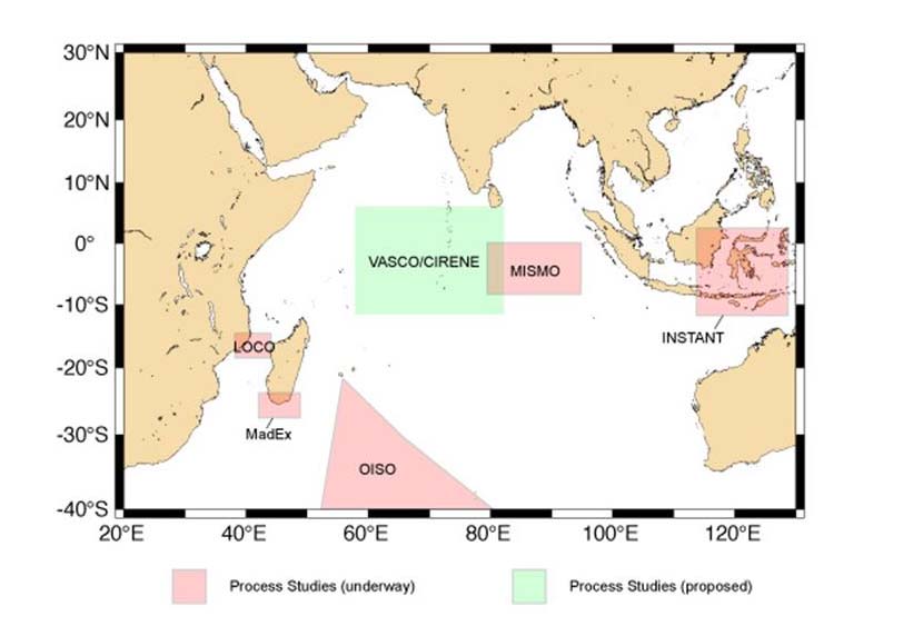
3.20 IndOOS
IndOOS is a basin-scale, integrated, observing system for climate research and forecasting in the
Indian Ocean. It is guided by the Indian Ocean Panel (IOP), established in 2004 by the International
GOOS Programme and CLIVAR (3.22 below) component of the World Climate Research Programme
(WRCP). IndOOS is based on moorings, floats, drifters and tide-gauge stations. It provides a spatial
and temporal context for process studies such as:
MISMO: http://www.clivar.org/organization/indian/IndOOS/MISMOupdateJUNE2005.pdf
VASCO-Cirene: http://www.lmd.ens.fr/vascocirene/
TRIO (Thermocline Ridge of the Indian Ocean):
http://www.clivar.org/organization/aamp/presentations/AAMP9/TRIO.pdf
17
Objectives & Main Thematic Areas
Figure reproduced from http://www.clivar.org/organization/indian/IndOOS/obs.php as
presented at the ASCLME Regional Forum.
MISMO and Vasco-cirene have both concluded. Key references are:
1. Duvel, J-P., C. Basdevant, H. Bellenger, G. Reverdin, A. Vargas and J. Vialard, 2009, The
Aeroclipper, Bull. Am. Met. Soc., 90, 63-71.
http://ams.allenpress.com/perlserv/?request=res-
loc&uri=urn%3Aap%3Apdf%3Adoi%3A10.1175%2F2008BAMS2500.1
2. Vialard, J., J-P. Duvel, M. McPhaden, P. Bouruet-Aubertot, B. Ward, E. Key, D. Bourras, R.
Weller, P. Minnett, A. Weill, C. Cassou, L. Eymard, T. Fristedt, C. Basdevant, Y. Dandoneau, O.
Duteil, T. Izumo, C. de Boyer Montégut, S. Masson, F. Marsac, C. Menkes, S. Kennan, 2009,
Cirene: Air Sea Interactions in the Seychelles-Chagos thermocline ridge region, Bull. Am. Met.
Soc., 90, 45-61.
http://ams.allenpress.com/perlserv/?request=res-
loc&uri=urn%3Aap%3Apdf%3Adoi%3A10.1175%2F2008BAMS2499.1
The Indian Ocean Panel implementation plan is at:
http://www.incois.gov.in/Incois/iogoos/IOP_Impl_Plan.pdf
A Community White paper on Observing Systems in the Indian Ocean is currently being
written. Lead author: Yukio Masumoto, Institute of Observational Research for Global
Change, masumoto@eps.s.u-tokyo.ac.jp TEL:+81-46-867-9835. Contributing authors:
Weidong Yu (wdyu@fio.org.cn), Gary Meyers (Gary.Meyers@imos.org.au), with
contributions from members of the CLIVAR/GOOS Indian Ocean Panel and national leaders
of regional activity.
18
Objectives & Main Thematic Areas
3.21 The Argo Programme
The Argo programme (www.argo.net) is described for the Indian Ocean at:
http://www.incois.gov.in/Incois/iogoos/argofloats.jsp
3.22 CLIVAR
As described on the CLIVAR website (http://www.clivar.org/), CLIVAR is the World Climate
Research Programme (WCRP) project that addresses Climate Variability and Predictability, with a
particular focus on the role of ocean-atmosphere interactions in climate. It works closely with its
companion WCRP projects on issues such as the role of the land surface, snow and ice and the role of
stratospheric processes in climate.
The two CLIVAR panels of most relevance to the WIO are VACS (Variability in the African Climate
System) which includes the neighbouring oceans, and IOP (Indian Ocean Panel) which is described
under section 3.20 above.
3.23 GOOS-Africa
As found on the Global Observing Systems Information Centre (http://www.gosic.org/goos/GOOS-
AFRICA-program-overview.htm), GOOS-Africa is a coordination committee established in July of
1998 for the purpose of promoting the development of GOOS in Africa.
Priorities for GOOS-AFRICA are:
· To form an Africa wide network of National Ocean Data Centers
· To upgrade the African network of GLOSS sea level stations
· To encourage access to and capability in Ocean Remote Sensing in Africa
· To facilitate Internet access and data transfer mechanisms.
3.24 Seamounts: EAF Fisheries Project
The global depletion of inshore and continental shelf fisheries, coupled with improvements in fishing
technology, has led commercial activities to fish further out and deeper into the oceans, including in
the high seas beyond national exclusive economic zones (EEZs), where they are subject to weak or
sometimes no regulation. In just ten years, between 1992 and 2002, the percentage of fish caught on
the high seas in relation to the global marine catch rose from 5% to 11%.
Seamounts are hotspots of biological diversity and production. They also host concentrations of
commercial pelagic fish (e.g. tuna) as well as deep-water fish species (e.g. Orange Roughy) that attract
commercial fishing activities. The combination of the lack of understanding of important oceanic
features such as seamounts and their interactions with commercial fish species and the existing gap in
the high seas marine biodiversity governance and regulatory system poses major threats to marine
species and their habitat. These gaps can allow unregulated and unreported activities, overexploitation
and pollution of marine resources and destruction of benthic habitats. Deep-sea bottom fisheries can
cause irrevocable depletion of commercially-important fish populations in just a few years, and
irreparable damage to slow-growing deep-seabed communities of cold water corals, sponges and other
animals.
The southern Indian Ocean remains the most significant gap in current knowledge of global seamount
ecology and biodiversity. In addition, no governance body yet has the mandate to conserve and
manage deep-sea ecosystems in the southern Indian Ocean. The Southern Indian Ocean Fisheries
Agreement (SIOFA) is not yet in force, and the only agreement currently in force in the region, the
19
Objectives & Main Thematic Areas
Indian Ocean Tuna Commission (IOTC), applies to the conservation and management of tuna and
tuna-like species. Although States fishing in the area have duties linked to international obligations
including UN General Assembly (UNGA) resolution 61/105 on sustainable fisheries and its paragraph
80 on protection of vulnerable marine ecosystems1 seamounts in the southern Indian Ocean are in
effect left unregulated.
This UNDP/GEF Project will directly address the three main barriers to sustainable fisheries
management and marine biodiversity conservation in the high seas, with a particular focus on
seamount ecosystems: 1. lack of scientific knowledge about seamount ecosystems and their
relationship with fisheries resources, due in large part to lack of capacity for monitoring, assessment
and analysis; 2. lack of comprehensive governance framework for marine biodiversity in the region;
and 3. difficulty in managing off-shore fish stocks, including monitoring, control and surveillance. The
proposed project will also make significant contributions to raising awareness of decision-makers, the
fishing industry and the general public on off-shore and deep-sea marine biodiversity, and serve as a
demonstration project for developing robust conservation and management measures for marine
biodiversity in areas beyond national jurisdiction.
3.25 Western Indian Ocean Marine Science Association
As described on the WIOMSA website (www.wiomsa.og):
WIOMSA is a regional professional, non-governmental, non-profit, membership organization,
registered in Zanzibar, Tanzania. The organization is dedicated to promoting the educational, scientific
and technological development of all aspects of marine sciences throughout the region of Western
Indian Ocean (Somalia, Kenya, Tanzania, Mozambique, South Africa, Comoros, Madagascar,
Seychelles, Mauritius, Reunion(France)), with a view toward sustaining the use and conservation of its
marine resources. The Association has about 1000 individual members as well as about 50
institutional members from within and outside the region.
The organization's inter-disciplinary membership consists of marine scientists, coastal practitioners,
and institutions involved in the advancement of marine science research and development. The
Association: (1) provides a forum for communication and exchange of information amongst it
members that promotes and fosters inter-institutional linkages within and beyond the region; (2)
supports marine research by offering research grants; (3) implements programs to build the capacity of
marine scientists and coastal management practitioners; and (4) works to promote policy dialogue on
key topics by organizing meetings and seminars on the findings and policy implications of science.
WIOMSA promotes marine science research through the award of research grants under the Marine
Science for Management (MASMA) and the Marine Research Grant (MARG) programmes. MASMA
is a competitive research grant scheme designed to support research activities in the region as well as
organisation of training courses/workshop. The grants, which range from US$ 15,000 to US$ 50,000
per annum, are available to teams of scientists or individual researchers from the region.
In addition to the on-going capacity building program in ICM and MPA, WIOMSA has
organized/hosted a number of regional workshops and meetings that provided the linkage between
science and management.
1 UNGA Resolution 61/105, para. 80, calls for States to take action immediately, individually and through
regional fisheries management organizations and arrangements, and consistent with the precautionary
approach and ecosystem approaches, to sustainably manage fish stocks and protect vulnerable marine
ecosystems, including seamounts, hydrothermal vents and cold water corals, from destructive fishing practices,
recognizing the immense importance and value of deep seas ecosystems and the biodiversity they contain.
20
Objectives & Main Thematic Areas
Recently, WIOMSA also signed Memorandum of Understanding with UNEP as the secretariat to the
Nairobi Convention, whereby WIOMSA will be responsible for providing research, technical,
managerial and advisory support to UNEP as requested.
WIOMSA in collaboration with UNEP is hosting a regional Group of Experts on Marine Protected
Areas for the Eastern African region (GEMPA). GEMPA has been established with the aim of
building a constituency for marine protected areas in the region and to provide a forum for linkages
and dialogue between MPA practitioners and experts, and between government and non-government
organizations.
List of FUNDED MASMA PROJECTS could go here.
3.26 Western Indian Ocean Projects of the Institut de Recherche pour le Développement (IRD) ;
in particular MESOBIO
The IRD = Institut de Recherche pour le Développement (http://ww.ird.fr) is a French public research
institute, funded by 2 ministries (Research and Education, Foreign Office)
EME (Exploited Marine Ecosystem) is the scientific structure of IRD (UMR research unit) dealing
with halieutic (fishery) science. EME started in January 2009 from the merger of 4 previous research
units, among which was THETIS (directed by Dr Francis Marsac).
Head of EME: Dr Philippe CURY. EME is hosted at the Centre de Recherche Halieutique
Méditerranéenne et Tropicale (CRH), at Sčte (France) - http://www.crh-sete.org
In the Western Indian Ocean, EME is present at La Réunion (IRD Réunion, BP 172, 97492 Sainte
Clotilde Cedex) and in Seychelles (RD Seychelles - BP 570 - Victoria, Mahé, Seychelles)
IRD / EME research programmes in the Western Indian Ocean are:
MESOP program which has been included in the MESOBIO (2009-2011) project. The MESOBIO
project is conducted by the IRD (EME team) in strong collaboration with scientists and organisations
from South Africa. The MESOBIO project (Influence of mesoscale dynamics on biological
productivity at multiple trophic levels in the Mozambique Channel) includes the activities developed
by IRD / EME in the Mozambique Channel on the role of mesoscale eddies on the whole trophic web.
MESOBIO has just been funded (MASMA grant) and is being implemented at the moment.
- MADE (European funds FP7, 2008-2012): Mitigating adverse ecological impacts of open
ocean fisheries
- BIOPS (ANR French grant, 2008-2010): Biodiversité des milieux pélagiques marins dans
l'Océan Indien
- SWIOFP (World Bank, 2008-2013) : France is member of SWIOFP. IRD (SWIOFP
representative: Francis Marsac) participates at two components: Data gap analysis, Data
archiving and Information technology (component 1) and Assessment ansd sustainable
utilization of pelagic fish (component 4).
Other Research Units of IRD have developed projects and programmes in the SWIO:
- COREUS: mapping / GIS activities with the ASCLME Project (S. Andrefouet)
- ESPACE: As a partner in AMESD (to be verified)
21
Objectives & Main Thematic Areas
MESOBIO
MESOBIO aims at understanding the influence of mesoscale dynamics (eddies) on the biological
productivity of the sea. The Mozambique Channel is very well suited for the study, as it is the place of
an intense mesoscale activity. Mesoscale eddies may enhance biological productivity by themselves
(through vertical exchanges induced by the eddies) and through the seaward export of coastal
productivity by circular currents associated with the structure. MESOBIO intends to investigate from
the physical processes associated with eddies, to primary (phytoplankton) and secondary
(zooplankton) production, then to forage fauna (micronekton) up to top predators (tunas, seabirds,
marine mammals). MESOBIO aims at developing a global ecosystemic approach.
3.28 The EAF Nansen Project
The long term objective of the EAF-Nansen project is to strengthen regional and country specific
efforts to reduce poverty and create conditions to assist in the achievement of food security through
development of sustainable fisheries management regimes and specifically through the application of
the ecosystem approach to fisheries in a number of developing countries at global level, with an early
emphasis on Sub-Saharan Africa.
The long term objective would be achieved through the provision of support for the development and
country driven application of the conceptual framework of the Ecosystem Approach to Fisheries
(EAF) through capacity-building, promoting standardized data collection and monitoring, supporting
policy development and management practices consistent with EAF principles and contributing to an
expanded knowledge base.
The Immediate Objectives of the project are to provide the fisheries research institutions and
management administrations in the participating countries with additional knowledge on their
ecosystems for their use in planning and monitoring, and to further the acceptance and application of
the key principles of the EAF. The key principles are that:
· fisheries should be managed to limit their impact on the ecosystem to an acceptable level;
· ecological relationships between species should be maintained;
· management measures should be compatible across the entire distribution of the resource;
· precaution in decision-making and action is needed because the knowledge on ecosystems is
incomplete; and that
· governance should ensure both human and ecosystem well-being and equity.
3.29 Agulhas Current Transport (ACT)
The project will deploy a three-year mooring array across the Agulhas Current off South Africa at
nominally 34S to measure its volume transport. The mooring array will be positioned offshore and a
little south of East London, where it will leave the African shelf at 33.4 S and follow the trajectory of
descending TOPEX/Jason ground track #96. These three years of in situ data will build towards long-
term monitoring capability of the Agulhas Current through correlations with sea surface height
fluctuations along the mooring line from satellite altimeter.
Three two-week cruises, eighteen months apart are planned, with the first deployment cruise
tentatively scheduled for March 2010. Seven full-depth moorings will be deployed, each with single-
point Doppler current meters at depths throughout the water column, topped with upward-looking,
profiling Doppler current meters at 350 m below the surface. In addition, four current meter- and
pressure sensor- equipped inverted echo sounders will be deployed offshore to capture meander
events. Finally, a tide gauge will be placed at the beginning of the line close to the coast, in shelf
waters of less than 50 m depth. Tidal data will be used to improve coastal altimetry products for the
building of the long-term Agulhas transport proxy.
22
Objectives & Main Thematic Areas
On each of the three ACT cruises, we will collaborate with the University of Cape Town (UCT) to
train three of their scientists and/or students at sea. This is a symbiotic relationship whereby we gain
three watch-standers and the South Africans gain experience and training at sea, as well as links with
US scientists. In addition, we will collaborate with a South African student on the production of the
coastal altimeter data, through the ALTICORE Africa program. These collaborations have been
established with Johann Lutjeharms and Frank Shillington at UCT, and Paolo Cipollini at National
Oceanography Centre, Southampton.
23
Funded activities
4. FUNDED ACTIVITIES
4.1 Wio-LaB
Project Objective 1: Reduce stress to the ecosystem by improving water and sediment quality
1.1: Assessing water & sediment quality
· Development of standard methods for assessing water & sediment quality
· Filling in gaps in knowledge of priority pollutants & their sources through a regional
monitoring programme
· Assessment of carrying capacity of major ecotones
· Identification of major hotspots of pollution
· Establishment of Regional Environmental Quality Standards for water and sediment quality
· Development of a long-term monitoring protocol
1.2: Managing municipal waste water (MWW)
· Implementation of demonstration projects on MWW management
· Development of guidelines for MWW management
1.3: Managing physical alteration and destruction of habitats (PADH)
· Implementation of demonstration projects on PADH management
· Development of guidelines for PADH management
Project Objective 2: Strengthen regional legal basis for preventing land based (LB) sources of
pollution
2.1: Legal framework
· Review of existing national legislation/regulatory frameworks
· Review of the status of ratification of international conventions
· Development and adoption of a Protocol on land-based sources and activities
2.2: Environmental Impact Assessment (EIA)
· Development of guidelines for transboundary EIA's
2.3: National Programme's of Action (NPA)
· Development of National Programmes of Action for land based activities by countries
2.4: Integrated Coastal Area and River Basin Management (ICARM)
· Promotion and enhancement of ICARM principles
· Implementation of a demonstration project on ICARM
Project Objective 3: Develop regional capacity for sustainable, less polluting development
3.1: Regional coordination
· Strengthen Nairobi Convention Secretariat and EAF/RCU
· Establishment of a regional International waters coordinating mechanism
· Creation of an East African node of the GPA Clearinghouse Mechanism
3.2: Training & education
· Addressing training needs for land-based sources & activities management
· Implementation of educational programs on land-based sources & activities
3.3: Stakeholder participation
· Establishment of private and public sector partnerships
· Strengthen stakeholder participation in land-based sources and activities management
· Implementation of a small grants programme
3.4: Transboundary Diagnostic Analysis & Strategic Action Plan
· Development of an updated, scientifically relevant and geographically focused TDA and SAP
24
Funded activities
4.2 ASCLME
The funded activities of the ASCLME are under four result areas (this is under revision):
1
INFORMATION CAPTURED FOR DEVELOPMENT OF THE TRANSBOUNDARY
DIAGNOSTIC ANALYSIS
1.1
Data and information review
1.2
Identification of data needs and data capture mechanisms to populate the 2 TDAs
1.2A Identify and prioritize ecosystem assessment and ecosystemic process information gaps in key
oceanographic areas of the ASCLMEs along with work-plans, cruise schedules, budgets and
responsibilities
1.2B Key knowledge gaps in near-shore (artisanal/subsistence) fisheries updated, nursery areas and
other rich biological habitat mapped or otherwise identified using existing information
1.2C Management and Policy gaps/needs identified as part of root cause requirements for TDAs
development (national and regional)
1.3
Active offshore and coastal oceanographic data collection to fill gaps in ecosystem assessment
and status as necessary for development of TDAs and SAPs
1.4
Baseline information obtained on persistent organic pollutants (POPs) within the LMEs
through use of key indicator species
2
LONG-TERM LME DATA COLLECTION, MANAGEMENT AND DISTRIBUTION
MECHANISMS ESTABLISHED
2.1
LME based indicators linked to national and regional M&E mechanisms are developed and
captured within institutional work programmes and budgets
2.2
A region wide socio-economic valuation of near-shore marine goods and services is
undertaken to gain greater understanding of the social and economic importance of these areas
2.3
National and regional data handling, storage and synthesis focal centres are established
2.4
Use of GIS and predictive models expanded to increase systems knowledge
3
TDAS AND STRATEGIC ACTION PROGRAMMES AND ASSOCIATED
SUSTAINABILITY MECHANISMS IN SUPPORT OF AN LME APPROACH ARE
ADOPTED
3.1
TDAs are negotiated and approved by technical stakeholders
3.2
SAPs are negotiated and approved by technical stakeholders
3.3
Financial resources are brokered to ensure financial sustainability of monitoring, evaluation
and information systems to support the LME approach
3.4
Institutional, programme and human capacity building requirements are identified and
addressed through training initiatives
4 LME COORDINATION, COMMUNICATION, AND PARTICIPATION
MECHANISMS ESTABLISHED
4.1
Effective and frequent communication and coordination established among the IAs, the
various projects under the programme and other related initiatives and institutions in the
region, including linkages with other GEF supported projects in Sub-Saharan Africa and
globally
4.2
Key policy stakeholders sensitized and engaged in LME process through appropriate
packaging and presentation of LME information and concepts
4.3
Stakeholder engagement, public involvement, participation, and environmental education
initiatives are developed and implemented in the region
4.3 Nairobi Convention Clearinghouse Mechanism
i. An operational, online database drawn from the list of parameters described in above
ii. Data available in the Clearinghouse portal and data gap analysis
iii. National level training on (remote) data uploading
iv. National level campaigns conducted for decision makers, experts and stakeholders
25
Funded activities
4.4 ODINAFRICA
The following activities were funded under each of the thematic work packages:
Coastal Ocean Observing System: Upgrading and expanding African network sea level network in
collaboration with the Global Sea Level Observing System, the University of Hawaii Sea Level
Centre, the Indian Ocean Tsunami Early Warning and Mitigation, the Benguela Current Large Marine
Ecosystem project. Details are available at www.iode.org/glossafrica. Other activities include training
on sea level data analysis and interpretation as well as collocation of GPS at some of the tide gauge
stations. The ODINAFRICA Sea Level Data Facility (www.sealevelstation.net) has been established
to provide information on tide gauge status, as well as real-time access to sea level data.
Data and Information Management: The National Oceanographic Data and Information Centres
(NODC) have been further developed and strengthened to manage a wide range of marine data and
information types. Support was provided for upgrading infrastructure in the NODCs (including
internet access and computer systems). Training courses have been organized on topics such as marine
biodiversity data management, numerical modeling, and the application of remote sensing and GIS to
coastal management. The participating institutions have developed a suite of data and information
products available through project website (www.odinafrica.org). These include: Directories of marine
and freshwater professionals, Catalogues of marine related data sets, Marine Species data bases, and
library catalogues. An electronic repository of marine related publications from/about Africa
developed through ODINAFRICA is available at: http://iodeweb1.vliz.be/odin/
Product Development and end user communication and information delivery: focuses on
identification of end users of marine/coastal data/information products and their requirements,
identification and development of set of core products to be prepared by each NODC, development of
national marine atlases as well as the African Marine Atlas (www.africanmarineatlas.net),
development of an African Marine Biodiversity database, improvement of atmospheric and oceanic
monitoring databases, and promotion and dissemination of outputs of the project to all stakeholders.
Details of national data services and products are can be accessed at the websites of each NODCs -
www.nodc-countryname.org (e.g. www.nodc-tanzania.org). ODINAFRICA publishes the WINDOW
newsletter 3-4times a year to provide information on project activities. The African Ocean Portal
(www.africanoceans.net) and the COSMARNews which are produced in collaboration with the
secretariat for the Coastal and Marine sub-theme of NEPAD provide information on all aspects of
marine and coastal management.
The current phase is ending in February 2009. A proposal for the next phase to start in March 2009 has
already been submitted to the Flanders UNESCO Science Trust fund for consideration.
4.5 ReCoMaP
There are numerous activities and projects that ReCoMaP is supporting in the region in addition to the
rather distinct Call for Proposals (see Result 6), the provision of training (see section 7) and the
regional assessments (see Section 8). These activities are funded under annual programme estimates
(PEs) and are designed to collectively contribute towards the improved functioning of ICZM in our
partner countries. Not all activities are straightforward to describe in brief. For example, in all partner
countries ReCoMaP's ICZM specialist is very active in supporting national institutions to develop
their ICZM policy and planning capacity. In some case (e.g. Madagascar) this includes specific
consultancies to propose options for new institutional arrangements for ICZM (further details area
available on request). Sections 4.1 to 4.7 presents a selection of ReCoMaP's other major activities for
2008-2009:
Kenya
26
Funded activities
A Management Plan for Prawn fisheries in Ungwana Bay: Support to the Fisheries Department in
Kenya to provide additional and complementary support this on-going work.
Mariculture: Support to the Kenya Marine & Fisheries Research Institute (KMFRI) towards the
establishment of a seaweed nursery and test plots on the south coast of Kenya.
Fisheries Information: A programme of support for improved generation of coastal small-scale
fisheries statistics is currently being developed with the Fisheries Department.
Madagascar
Fisheries Information Systems: A consultancy has recently been completed by a Madagascar-based
consultancy company, in collaboration with the Ministry of Agriculture, Livestock and Fisheries
(MAEP) to undertake a preliminary assessment of recent and ongoing coastal small-scale fisheries
monitoring programs. Following the presentation to stakeholders, ReCoMaP will work the MAEP to
facilitate the design of a cost-effective, accurate and hopefully sustainable fisheries information
system for Madagascar's coastal fisheries. It is anticipated that a pilot region will be selected to trial a
fisheries information system.
Mauritius/Rodrigues
Mariculture and integrating Mariculture planning into ICZM: ReCoMaP and UNDP recently
supported a mariculture planning workshop, covering seaweed as well as other potential targets of
mariculture in Rodrigues. A SWOT analysis indicated that seaweed farming does not hold much
promise at the moment, but that sea-cucumber ranching or farming may be feasible. To this end, we
are supporting further analysis of the opportunities in partnership with the Albion Fisheries Research
Centre in Mauritius, and IHSM in Madagascar.
Seychelles
Fisheries Statistics: Support to the Seychelles Fishing Authority (SFA) to building capacity for the
sustainable management of small-scale fisheries in the Seychelles through technical support for the
improvement of SFA's fisheries monitoring systems.
Tanzania
Strengthening artisanal fisheries statistics in Tanzania: ReCoMaP is developing a programme with the
Fisheries Division in Tanzania to support the on-going improvement of fisheries statistics in the
country. This work will be closely integrated with MACEMP activities in the Rufiji-Mafia-Kilwa
districts of Tanzania.
Regional Activities
ReCoMaP has successfully employed the EU's Direct Award facility to provide grants totaling
approximately Euro150,000 to CORDIO-EA and WIOMSA.
CORDIO: The grant will cover the costs of an extended socio-economic monitoring of coastal fishers.
This work will be implemented under the highly successful SocMon-WIO programme that has been
under-way in the region since 2005.
The activities to be supported include:
1. Site-based training for socio-economic monitoring using SocMon-WIO materials and training
approaches;
2. Supporting on-going socio-economic monitoring in Tanzania and Kenya; and,
3. Integrating information on resource users into existing management decision-making
arrangements.
WIOMSA: The grant will go towards supporting the implementation of the first COMPASS
programme for the certification of MPA managers in the WIO region.
27
Funded activities
Practical Guidelines for Solid-Waste Management in Coastal Regions is being developed and should
shortly be available.
Awareness-raising: In all partner countries ReCoMaP is providing a limited number of small-grants
(of less than Euro10,000) to local media organizations to promote ICZM-related awareness raising
activities. Similarly, small-grants are being awarded to non-media organizations (government and non-
governmental) to extend their ICZM-related awareness-raising programmes (further details are
available on request).
School-Contest: A school-contest has been successfully held in Mauritius and Rodrigues. A similar
event is currently underway in Seychelles, and further contests are planned for Madagascar (2008),
Kenya and Tanzania (2009).
MPA Call for Proposals
ReCoMaP will be launching a Call for Proposals (valued at approximately Euro600,000) for Marine
Protected Areas (MPAs) in September 2008. Further MPA-related activities may include a regional-
based training opportunity to link in and support the WIOMSA COMPASS initiatives.
4.6 RAMP-COI
Comoros: Supporting the Moheli marine park and the development of a sustainable whale-watching
eco-tourism with the local population around MPA in Mohéli, Grande Comore and Anjouan.
Madagascar: Supporting the process of creation of two MPAs in Andavadoaka (Velondriake) and in
southwest Toliara . ; Supporting the construction of interpretative center and souvenirs shop in Nosy
Tanikely to provide income generating activities.
Mauritius: Supporting the creation of the Rivičre Banane marine reserve and the development of
income generating activities for local communities in Rodrigues and supporting the creation of the
Balaclava MPA in Mauritius through marine inventory.
Seychelles: Supporting a demonstration project for monitoring of MPA and high biodiversity island
using radar technology (radar installation in Curieuse, Cousin and Aride). Supporting Aldabra WHS
in developing best management practices through the production of alternative renewable energy.
Supporting Cousin Island Special Reserve in establishing marine baseline for monitoring programme
and supporting sustainable marine ecotourism techniques in St Anne marine park.
4.7 AMESD
Support for the management of fishery resources in the south west Indian Ocean
Data archive and dissemination system enabling:
· Processing and the visualization of archive data relating to the observation of the oceanic
environment
· Cross-analysis of data relating to the observation of the oceanic environment and data on (e.g.)
ship positions
· Calculation and analysis of the evolution of climatologically parameters (e.g. elevation of the
sea level, frequency of wind, surge)
Software application will allow:
· Visualization of time averages (days, months, year, seasons) of data (e.g. CHL-a and SST)
· Extractions of archive data for particular points or zones (e.g. upwelling coastal zones, fishing
zones)
· Animation of time series plots
· Statistical analysis, including correlations between data
· Interface to analyze the correlations between ocean observation and fishing data
28
Funded activities
Monitoring and control of fishing activities in the south west Indian Ocean
· System allowing reception (via thematic station-EumetCast), visualisation & processing ocean
observation data & conceptualizing near-realtime products to observe and monitor fisheries
resources
· Realtime monitoring of local systems such as productivity zones, upwelling or alert system
against toxic algal blooms can be developed at a later stage based on data retrieved and
products generated
Physical oceanography and support for the management of maritime risks
· Processing and visualization of archive data of physical oceanography
· Analysis of the evolution of climatological parameters (e.g. sea level elevation, wind and
surge frequencies)
· Modelling of regional marine hydrodynamics (followed by prediction of drifting objects at
sea)
4.8 SWIOFP
The project will be funded for an initial duration of 5 years with a possible extension of 5 years. In the
first five years the project aims to accomplish a number of items namely
· Production and adoption of joint fisheries TDA (transboundary diagnostic analyses) and SAP
(strategic action plans) by all eight countries participating in project
· Formal agreement by all countries on policy, institutional and legal framework governing
ecosystem-based management of specific transboundary fisheries
· Adoption by all SWIOFP countries of environmental status and stress reduction indicators that
define ecosystem health within the framework of a regional management institution legally
mandated to undertake this function
· Adoption of at least one national or multi-national management plan for a specific demersal,
pelagic or crustacean fishery by each country participating in the project
· Establishment of a regional fisheries database based on new and historic data including
repatriated data
4.9 COAST-MAP-IO
Phase I: This will be a joint analysis by IOC/IHO and local experts to determine local capability for
the project, and methods of building this capability to create the required datasets. This will be
followed by joint actions [IOC/IHO and local experts] in participating countries to collate available
information on onshore-offshore morphology within their coastal zones. For the most part, this
information will be sought in partnership with national mapping agencies (including the Hydrographic
Services of participating states) that undertake bathymetric and topographic surveys on a systematic
basis.
Capacity-building programs will be formulated to:
· Enable national hydrographic agencies to assemble, quality-control and load existing
information into national databases
· Train agencies responsible for Disaster Management and Preparedness to create a series of
provisional maps that aid preliminary risk analyses and identify areas that need special
surveys
· Work with national coastal management and planning organisations to utilise present datasets
in creating useful products and identifying areas for further surveys
Plan new surveys to be implemented by national agencies that enhance existing coverage and meet the
requirements of other national bodies.
Phase II: New data will be integrated with existing observations to create a comprehensive database
and improved maps. In particular, acquisition of available airborne or satellite observations of
29
Funded activities
topography over land, and airborne LIDAR mapping of the inter-tidal zone, along with its seaward and
landward margins will be provided, in order to ensure the seamless continuity of on-shore/off-shore
relief measurements.
Working with coastal management agencies, varied data products coastal bathymetry, tide gauge
data, morphology of coastal areas, and available GOOS operational products will be used to produce
integrated data sets. These data sets will be used in coastal engineering models in coastal zone
development and predictive scenarios for decision makers in long-term planning. Continuous
improvement and updating of these datasets after this project will hinge on such applications, in
addition to their primary purpose for emergency planning.
Capacity-building programs during this phase will be focused on the selected Pilot Project site:
· Integration of varied data sources from surveys, sea-level GLOSS type stations, the Marine
Atlas being produced by ODINAFRICA, remotely-sensed and in-situ data
· Training in operating coastal engineering models and Graphical User interfaces for effective
presentations to decision makers
· GIS training for data mapping and as management tools in Disaster Management and
Preparedness
· Training in Integrated Coastal Area Management using integrated data sets and results from
numerical models
· Preparation of inundation maps by National Agencies for the Pilot Area identified during
Phase 1
4.10 WIO Cetacean Conservation and Research
This project is in the proposal stage.
4.11 TRANSMAP
In order to achieve the project's central goal, the work conducted in each of the sites will focus on the
following specific research objectives or operational goals defined in the following 12 workpackages:
1. Existing Knowledge: To compile and assess the existing information from the two transboundary
areas (SA/Mozambique, and Mozambique/Tanzania). Hence information on coastal biological
resources, physical and chemical phenomena and characteristics, living resources, socio-economic
characteristics as well as existing formal and informal legal and institutional frameworks should
be gathered from different sources.
2. Mapping Habitat Types and Current Uses: Tasks focus on the development of a geographic
information system (GIS) and the collection of geospatial data for the TRANSMAP project study
area. Specific objectives include: i) the classification and mapping of coastal habitat types using
satellite remote sensing (coral reefs, coastal dunes, mangroves, seagrasses, tidal flats, and coastal
lagoons); and, ii) the merging of GIS layers depicting current land- and sea-uses.
3. Biodiversity and Condition Evaluation: Specific objectives are: (1) to assess the biodiversity in
each of the habitats; (2) to identify "hot spots" that possess either unique species assemblages or
are uniquely species rich or both; (3) to identify critical habitats nursery grounds, spawning
aggregations; (3) to assess the relative contribution of each habitat to the ecological functioning of
the region (at regional scales); (4) to assess and evaluate the available information regarding the
status of different habitats and ecosystems of the two considered areas.
4. Special taxa: To assess the occurrence of rare and endangered species and their habitats in the two
regions.
5. Connectivity Assessment: To assess connectivity potential between the reserve units.
6. Sources and uses: Investigates the socio-economic conditions and trends in the study regions and
how they relate to coastal and marine resources.
7. Socio-economic needs: This aims to undertake a participatory assessment of stakeholders and their
concerns in relation to the creation and management of MPAs. The research involves (1)
30
Funded activities
identifying the main stakeholders and scoping their interests; (2) increasing general understanding
among key stakeholders of MPAs [and transfrontier conservation approaches]; (3) facilitating the
articulation of stakeholder values, concerns and priorities.
8. Policy, legal and institutional framework: Will identify the pertinent international (global and
regional) and domestic (national and provincial) policy, legal and institutional instruments that
serve as the framework for marine protected areas in Eastern Africa.
9. Operational assessment and state of management: This will identify, inventory, describe and
analyse existing and proposed national economic development, integrated coastal and ocean
management, and sectoral management plans that have an actual or potential impact for
prospective MPAs in the countries concerned.
10. Options for MPA zoning: In this it is intended to integrate the information gathered by the
different project components and address a final proposal of alternative zoning plan scenarios for
the considered case studies, in an appropriate format for decision-making organisations.
11. Use and dissemination of knowledge: The use and dissemination of knowledge between
participants and different level stakeholders and end-users, and the promotion of results and
interaction among decision-making structures. In particular the representatives of established
marine protected areas will be involved. This may increase the chances of use of the project results
in generating effective local and regional policies. Also public participation and awareness are
targeted, including the involvement of different level educational experts.
4.12 Marine Highway Project
· Hydrographic survey of entrances to Ports
· Hydrographic survey of proposed marine Highway along the Mozambique Channel
4.13 WIOFish
The database was initiated in 2004 with data from five countries: Kenya, Mozambique, Seychelles,
South Africa and Tanzania. It is anticipated that information from other countries in the WIO,
including, but not limited to, Madagascar, Mauritius, Comoros and Reunion (France) will be included
within the next two years. The database is designed to increase the understanding of the small-scale
traditional fisheries of the Western Indian Ocean by providing holistic descriptions of the fisheries
including attributes such as catch composition, vessels and gear used, habitats within which the
fisheries operate, management strategies and socio-economics. The database is therefore populated
with as many WIO fisheries and their respective descriptions as possible. While basic catch
information is included such as species contributing more than 5% of the total catch, catch rates and
total catches, it is not the intention of the database to provide comprehensive catch statistics.
Links to appropriately related statistical database websites will be included.
4.14 Long-Term Ocean Climate Observations LOCO
-
4.15 UNESCO/IOC and the Capacity Development Programme in the WIO region
The first phase of the IOC Capacity Development programme activities in the region will finish in
2008 and A new proposal is under development for the next phase covering 4 years of activities. The
training priorities of both phases are documented in section 7.
4.16 IUCN
4.17 ACEP
The vision of ACEP II is to Build the capacity to sustain the processes which support life, and the aim
of the ACEP II is to build on the good work that has been done before and ensure that the vision and
objectives is achieved through high quality research. The open call for ACEP II projects were a
31
Funded activities
success and eight proposals involving 30 scientists from 10 research institutions in South Africa were
awarded funding. These were:
1) Biodiversity and Coelacanths
Title: Investigating African Coelacanths, their ecosystems and surrounding deep water environments
through integrating multidisciplinary research focusing on biodiversity and ecology
2) Conservation planning
Title: The application of systematic conservation planning to the high resolution biological,
oceanographic and threats data collected over the last seven years by EKZN Wildlife for the waters of
the EEZ off Kwazulu-Natal to assess biodiversity status and recommend placement of MPAs
3) Education
Title: Accessing and use of scientific knowledge resources for public understanding and
environmental education
4) Coral & climate change
Title: Sampling and analysis of coral core from the Sodwana coral reef system to determine decadal
variations in sea surface temperature, geochemistry and climate.
5) Genetics
Title: A phylogenetic investigation of differentiation of the marine fish fauna of the South Western
Indian Ocean at different temporal and spatial scales.
6) Natal Bight Ecosystem
Title: Ecosystem processes in the KZN Bight: linking geological, biological and physical processes to
understand ecosystem functioning.
7) Agulhas Current Ecosystem
Title: A multi-disciplinary study of the landward edge of the Agulhas Current along its full length and
its influence on the adjacent shelf (Figure 1), including the Agulhas Bank (Figure 1).
8) Database
Title: An integrated web-based data and metadata system, using Geographical Information Systems
(GIS) to understand biophysical processes.
Local programme collaboration
1) Algoa Bay: Algoa Bay Long Term Monitoring and Research Programme (Algoa Bay LTMRP). The
new coastal research boat (13 m Lee-Cat) will play a major role in observation studies along the coast
of SA. In collaboration with SAEON long term monitoring lines off Algoa Bay and Port Alfred will be
set up to investigate long term variation and climate change impacts on the coastal region.
2) Tsitsikamma National Park (TNPA): Establishment of a long-term monitoring site for sub-tidal
nearshore reef communities of the warm-temperate biogeographic region. The Remotely Ooperated
Vehicle (ROV) will provide capacity to undertake observation in areas previously to deep to monitor.
The programme at TNPA involves establishing deep water monitoring protocols that can be
implemented along the South African coast.
4.26 MESOBIO
Different components of the MESOBIO project are self-funded (for instance, ship time availability
from IRD for the MESOP cruise onboard the R/V ANTEA, support from ASCLME and ACEP for
future cruises onboard R/V Algoa and/or R/V Fridtjof Nansen). Complementary funds have been
requested from WIOMSA (MASMA grant), from European grant at La Réunion (top predators
component). Support from ASCLME and ACEP could also be requested for complementary funds.
32
Data nodes
5. DATA NODES AND MANAGEMENT SYSTEMS
5.1 Wio-LaB
As one of its activities, the WIO-LaB project supports implementation of the Clearinghouse and
information sharing system of the Nairobi Convention to serve as a regional clearinghouse node for
the Global Programme of Action for the protection of the marine environment from land based
activities. Besides hosting data generated by WIOLaB activities, the national and regional
Clearinghouses are repositories of geospatial and socioeconomic data, and acts as information sharing
platform for the Eastern Africa coastal and marine environment. As such, Wio-LaB data nodes are the
same as CHM nodes.
5.2 ASCLME
The ASCLME will use a distributed management system for data, where every participating country
manages and archives the data for that country, collected or used during the MEDA/TDA/SAP
process. Since the long term goal of the ASCLME Project is to build capacity in national
institutions to support data collection, management and use to inform decision-making, the Project
will use existing national data systems and repositories and support capacity building (infrastructure /
training) where it is needed and requested. Data nodes and their funded activities are aligned with
those of ODINAFRICA (IOC/UNESCO) and the Nairobi Convention. Several data nodes are used in
each country depending on the discipline of interest (taxonomy/oceanography/fisheries); these are
described in the ASCLME Data and Information Management Plan.
5.3 Nairobi Convention Clearinghouse Mechanism
· Data nodes are as described in Section 2
· Each lead country institution has been provided with a high-end data server for data repository
· A team of experts at national level with a broad range of expertise representing different
institutions/stakeholders act as a National Working Group (WG) for the coordination of the
activities related to collection, collation and formatting of metadatadata and information uploaded
into the national clearinghouse node server by WG which also carry out initial analysis of the data
to identify critical environmental emerging issues.
5.4 ODINAFRICA
The data nodes are the National Oceanographic Data and Information Centres located in the Focal
Point Institutions.
5.5 ReCoMaP
ReCoMaP is engaged in supporting provision of improved data and information contributing to ICZM
decision-making (e.g. on fisheries, coastal erosion, coastal eco-tourism etc). However, we have not
established any data nodes or programme-specific data management systems as such, but rather we
support the functioning of existing systems. The only programme-specific information management
system we are promoting is a Knowledge Management System (KMS) for ICZM. This will be a web-
based system that offers selected papers, reports, images etc related to ICZM as a process, rather than
a library of sector-based material. The contents will be largely defined and ranked by our ICZM
specialist and from contributions from our Regional Technical Advisory Panel. The system is
developed and based on open-source Knowledge Tree and should be on-line by the end of 2008.
5.6 RAMP-COI
The project will develop a regional biodiversity data base in collaboration with WCS Madagascar. The
data base already exit for the terrestrial biodiversity of Madagascar. It will be extended to the marine
biodiversity in the IOC countries, in the frame of the eco-regional analysis (component 1 of the
project).
5.7 AMESD
The service will be composed of a data archive and dissemination system installed in institutions in
charge of the management of fisheries resources (see focal point institutions). Products and services
33
Data nodes
provided should notably enable improved detection of climatic evaluations and/or variations of
parameters of the oceanic environment and analysis of its consequences on marine resources. The
archive data will be stocked and processed in part at the MOI, Mauritius.
5.8 SWIOFP
Data Gap Analysis, Data Archiving and Information Technology Component (Kenya)
SWIOFP will establish a regional data management system to underpin information needed to ensure
management of regional fisheries and to undertake a gap analysis to identify the specific research
activities to be supported by the project. This regional database will be created during the first year of
the Project and will continue to operate and service the participating and observer countries in
SWIOFP, expanding the database with new information from the SWIOFP research cruises and other
relevant data input from projects in the SWIO. The project database will include fields for existing
data describing by-catch, and provision for adding information from Project-leased and commercial
vessels (that have Project observers onboard).The gap analysis will rely on the development of a data
atlas of historic data describing offshore fisheries of the WIO. A single regional fisheries database will
be created using the data atlas, which reflects published information, along with repatriated and
consolidated data from various sources. National fisheries related IT and communications
infrastructure will also be procured or upgraded for each of the nine countries along with training in
data handling and reporting
5.9 COAST-MAP-IO
· Country-specific databases, formatted and ready for merger into sub-regional or regional
databases
· Bathymetric data sets complemented by flooding/inundation maps. (These will indicate levels
of vulnerability to tsunami damage caused by wave action at the coast, and by flooding at
inland locations). Zones that are most at risk of future catastrophic events will be the
priorities for support and resources.
5.10 WIO Cetacean Conservation and Research
Funding from the French Ministry of Foreign Affairs will allow the development of a tool, in the form
of a protected database accessible on the Internet and supported by CD or DVD, making it possible to
centralise the photographic data collected on the humpback whales in the various countries of the COI
and to facilitate the exchange between these various structures. This tool will meet the needs expressed
at the first workshop of study and conservation of the Cetacean of the countries of the COI, which was
held at Isle St. Marie (Madagascar) in July 2007. This project will make it possible to harmonize the
protocols of photographic data acquisition and to develop and exploit on a regional scale the data
accumulated over several years by the local actors.
5.11 TRANSMAP
WP1 (TRANSMAPMeta-database): The purpose of this web-interface meta-database is to facilitate
data collection within the TRANSMAP Project. This involves the identification and indexing of data
(both historic and existing) relating to the various research thrusts of the project, which are biophysical
(habitat and species distribution, biodiversity assessments namely hotspots and current conditions),
socio-economic (resource use, and human community distribution), governance (existing legislation
and basic institutional frameworks), existing protected areas and framework, as well as geo-analytical
support (aerial and satellite imagery, spatial information etc).
WP2 (TRANSMAP Map server): Is already available at `http://internal.bio3.pt/transmap', the
TRANSMAP map server. This map server is a simplified TRANSMAP GIS for public use which is
being facilitated through the implementation of a manifold IMS application by Bio3 (see details under
consortium/FUL). It is the main objective of the TRANSMAP map server to publish the GIS data and
maps to the internet, allowing the public to see many of the information that is being used to develop
the scientific basis for the creation of transboundary networks of Marine Protected Areas (MPAs). It is
34
Data nodes
also intended to allow the public to interactively query the data and to download information and save
pictures of the maps
Fieldwork was undertaken in the following locations:
· Southern Tanzania, region of Mtwara: Mbuo, Mngoji and Chui villages;
· Northern Mozambique, province of Cabo Delgado: Palma Sede, Quirinde, Mocimboa da Praia
and Ulo;
· Southern Mozambique, district of Matutuíne: Santa Maria (with more rapid assessments also
involving Ponta do Ouro, Movukuza, Mucombo and Inhaca island);
· South Africa, province of KwaZulu-Natal: St Lucia town, Khula, Sokhulu, Sodwana and
Mabibi.
Currently, the data collected in the field are being analysed. The following outputs are being prepared:
· A database of coastal use and change
· An analysis of the socio-economic dynamics of the region
· An assessment of threats and opportunities for marine conservation
5.12 Marine Highway Project
-
5.13 WIOFish
The WIOFish Online Database www.wiofish.org is managed and updated by a regional node, in close
collaboration with the national nodes. Presently, the regional node is the Oceanographic Research
Institute (ORI) from South Africa who has led the development of the database, in collaboration with
IUCN-EARP. The national nodes are those listed in the focal point institutions section above.
5.14 Long-Term Ocean Climate Observations - LOCO
-
5.15 UNESCO/IOC and the Capacity Development Programme in the WIO region
IOC supports building capacity in data management primarily through the ODINAFRICA
programme, implemented through the National Oceanographic Data and Information Centres.
In addition, institutions involved in the Capacity Development (CD) and other IOC
programme activities produce and manage data on a project by project basis. This is done in
coordination with ODINAFRICA and the National IOC Action Addresses listed in Section 1.
The Capacity Development (CD) programme focuses on institutional training and
development of products and applications - developing and utilising the data rather than
building capacities in data management nodes or clearing houses themselves. The programme
seeks partnership in the region to jointly develop such capacities and products.
5.26 MESOBIO
As part of (or associated with) ASCLME and SWIOFP programme, MESOBIO will
contribute to the data management systems developed within these programmes. Also, French
cruises are intended to contribute to French oceanographic data bases.
35
Case study sites
6. CASE STUDY SITES
6.1 Wio-Lab
· Kenya - Mombasa: A wetland-lagoon system for wastewater management at Shimo La Tewa
Prison
· Madagascar Toliara: Development of eco-tourism in the Marine Park of Toliara
· Tanzania - Dar es Salaam: Application of vetiver grass for erosion and leachate control at a
landfill site
· Mauritius Port Louis : Solid Waste Management in Port Louis Harbour
· South Africa: Integrated Algal Ponding System technology for the polishing and beneficiation
of effluent from municipal sewage treatment facilities
· Mozambique: Enhancing the ecological function of mangroves
· Tanzania Pemba Island: Wastewater management on Pemba Island
· Comoros Mohéli: Integrated management and protection of the coastal zone at Itsamia
· Mauritius - Black River Gorges National Park: Use of native species to control soil erosion
within The Black River Gorges National Park
For more information on these projects see webpage
http://www.wiolab.org/Demonstration%20Projects/Demonstration%20Projects
6.2 ASCLME
Case study sites will be identified during the course of 2009
6.3 Nairobi Convention Clearinghouse Mechanism
-
6.4 ODINAFRICA
Sites where ODINAFRICA has installed tide gauges:
Kenya Mombasa
Kenya Lamu
Madagascar Nosy
Be
Mauritius Port
Louis
Mauritius Rodrigues
Mozambqiue Inhambane
Mozambqiue Pemba
Seychelles Pt.
Larue
Tanzania Zanzibar
Tanzania Mtwara
6.5 ReCoMap
Kenya South coast: Mariculture Development Support
Kenya Ungwana Bay: Prawn Management Plan
Madagascar Toliara: MAEP - Octopus Stock Assessment
Mauritius/Rodrigues - Albion/Rodrigues Assembly (Sea Cucumber Mariculture).
Tanzania RuMaKi : Artisanal Fisheries Information
Madagascar - Regional Fisher Migration Study
36
Case study sites
6.6 RAMP-COI
Comoros: Moheli Marine Park
Comoros: MPA development for Mohéli, Grande Comore and Anjouan
Madagascar: Two MPAs in Andavadoaka (Velondriake) and in southwest Toliara
Madagascar: Supporting interpretative center and souvenirs shop in Nosy Tanikely
Mauritius: Rivičre Banane marine reserve
Mauritius: Income generating activities for local communities in Rodrigues
Mauritius: Balaclava MPA
Seychelles: Supporting a demonstration project for monitoring of MPA and high biodiversity island
using radar technology (radar installation in Curieuse, Cousin and Aride)
Seychelles: Aldabra WHS in developing best management practices through the production of
alternative renewable energy
Seychelles: Supporting Cousin Island Special Reserve in establishing marine baseline for monitoring
programme
Seychelles: supporting sustainable marine ecotourism techniques in St Anne Marine Park.
6.7 AMESD
-
6.8 SWIOFP
-
6.9 COAST-MAP-IO
-
6.10 WIO Cetacean Conservation and Research
Feasibility study for the creation of a regional cetacean network (40 000 , ReCoMaP 9th EDF)
6.11 TRANSMAP
The transboundary case study areas proposed herein constitute important biogeographical units with
unique character, and referred to by the World Wildlife Fund (WWF) and the East African Marine
Ecoregion (EAME) as priority areas:
1. in the boundary between South Africa and Mozambique which comprises the Greater St Lucia
Wetland Park World Heritage Site, an important centre of marine turtle nesting and also
bearing the southern-most coral reefs in the world, among a heterogeneous mosaic of different
coastal habitats such as mangroves, seagrass beds, coastal dunes and estuarine lagoons
2. in the boundary between Mozambique and Tanzania, some of the most impressive coral reefs
of the Western Indian Ocean, dispersed through a complex of coastal islands significantly
affected by recent coral bleaching events, as well as periodic dynamite fishing in Tanzania.
These two case study sites present unique and challenging opportunities to develop and test
methods that can accommodate the various ecological and socio-economic complexities
addressed by the research.
Fieldwork was undertaken in the following locations:
· Southern Tanzania, region of Mtwara: Mbuo, Mngoji and Chui villages;
· Northern Mozambique, province of Cabo Delgado: Palma Sede, Quirinde, Mocimboa da
Praia and Ulo;
· Southern Mozambique, district of Matutuíne: Santa Maria (with more rapid assessments also
involving Ponta do Ouro, Movukuza, Mucombo and Inhaca island);
· South Africa, province of KwaZulu-Natal: St Lucia town, Khula, Sokhulu, Sodwana and
Mabibi.
6.12 Marine Highway Project
37
Case study sites
Overall coastal and marine areas, but more specifically ESAs, including MPAs and coastal and marine
areas identified as being of major ecological and economic high importance. These sites will be taken
on board in designing site specific OSCP plan for protection.
6.13 WIO-Fish
-
6.14 Long-Term Ocean Climate Observations LOCO
-
6.15 IOC CD
A number of pilot projects have been initiated through the trainings undertaken in hydrodynamic
modelling, and spin off projects. Collaboration on further development/transfer of the skills and
project outcomes may be possible with the national components of other regional project. Example
sites include the following where hydrodynamic models are under development:
· Kenya Mombasa harbour
· Mozambique Maputo harbour
· Mozambique - Pemba near shore
· Seychelles Victoria near shore
· Tanzania Zanzibar Channel
· Tanzania - Zanzibar shoreline change
· Tanzania Dar es Salaam harbour
6.16 IUCN EASARO
· MPA management planning and Capacity Building in Sudan and Somalia
· Continued of intervention in Tanga
6.26 MESOBIO
MESOBIO activities will focus exclusively on the Mozambique Channel. Repeated cruises are
necessary to face with different processes involved in the enhancement of biological production by
mesoscale eddies. Also, different sectors within the Mozambique Channel have to be investigated
independently (for instance, southward migration of eddies along the western coast of the Channel
Mozambique, vs northward trajectory of southern eddies along the coast of Madagascar).
Other IRD / EME: Case study sites
The IRD/EME MICROTON project (see below) will concern the Mascareigne Plateau (between La
Réunion and Seychelles) and the north of Seychelles. Generally speaking, IRD has a long experience
of marine (fishery) research around the Seychelles due to long-time partnership with local scientists,
especially from SFA.
38
Cruises
7. CRUISES
Summary table
Year Month Project
Vessel Cruise
# Contact Study Area
Ports visits
Nature of research
Person
2008
ASCLME Dr
ASCLME Tommy
East Madagascar
Madagascar
Oceanography/
Fridtjof
1
Bornman
biodiversity
Nansen
2008
ASCLME Dr
ASCLME Tommy
Mauritius Mauritius
Oceanography/
Fridtjof
2
Bornman
biodiversity
Nansen
2008
ASCLME Dr
ASCLME Tommy
Mascarene Plateau
Mauritius,
Oceanography/
Fridtjof
3
Bornman
Seychelles,
biodiversity
Nansen
Comoros,
Mozambique
2008
ASCLME Dr
ASCLME Tommy
Mozambique channel
Mozambique, Oceanography/
Fridtjof
4
Bornman
South Africa
biodiversity
Nansen
2009
ASCLME Dr
ASCLME Tommy
East Africa Current
Kenya,
Oceanography/
Fridtjof
1
Bornman
Tanzania
biodiversity
Nansen
2009
ASCLME Dr
ASCLME Tommy
Comoros Basin
Comoros
Oceanography/
Fridtjof
2
Bornman
biodiversity
Nansen
2009
ASCLME Dr
ASCLME Tommy
Mascarene Plateau
Seychelles,
Oceanography/
Fridtjof
3
Bornman
Reunion
biodiversity
Nansen
(France)
2009
ASCLME Dr
ASCLME Tommy
South-West Indian South Africa
Oceanography/
Fridtjof
4
Bornman
Ocean
biodiversity
Nansen
2009
ACEP
RV
Tommy
Natal Bight
South Africa
Oceanography/
Algoa
Bornman
biodiversity
2009
ACEP
RV
Tommy
Agulhas shelf
South Africa
Oceanography/
Algoa
Bornman
biodiversity
2009 10/24/09
MESOP IRD Jean-
Reunion
to
R/V
Francois
(France)
11/10/09
ANTEA
Ternon
2009
1 Jan to NCAOR
Dr.
M.
South
Africa,
5 April
Sudhakar;
Mauritius
msudhaka
r@ncaor.
org
2009
Roger shipsked
South
Africa,
Revelle
@ucsd.ed
Seychelles
u
2010 Proposed
MICROTON IRD
Jean-
Seychelles,
for April
R/V
Francois
Reunion
ANTEA
Ternon
(France)
2011
TRIO
RV
Jérôme
Seychelles
See TRIO science
Atalante
Vialard,
plan:
Jean-
http://www.lmd.ens.fr
Philippe
/jpduvel/trio/
Duvel
TRIO_science_plan
_oct08.pdf
2011
CINDY -
In TRIO science plan Mostly
the A follow-up to
Japan
central
MISMO, duration 2
equatorial
months
Indian Ocean
2011/2
PIA Murata -
a repeat of a WOCE Following
CO2 measurements,
Japan
cruise (I02,
8°S through duration 2 months
see http://whpo.ucsd.
most of the
edu/maps/ind_map.ht
Indian Ocean
ml )
39
Cruises
Other information resources for ship-based expeditions:
www.researchvessels.org
UNOLS Ship Time Request and Scheduling System (STRS)
http://unolsweb.cms.udel.edu/STRS/Public/Search/diu_all_schedules.aspx
http://ioc3.unesco.org/ioccp/Underway/New_GlobalUWMap.html
CLIVAR and Carbon Hydrographic data office
(http://whpo.ucsd.edu:80/maps/ind_map.html)
CARBON UNDERWAY MAP: On-going and Planned Cruises
International Ocean Carbon Coordination Project - Last Updated: November 2007.
http://ioc3.unesco.org/ioccp/Underway/New_GlobalUWMap.html (see figure below)
40
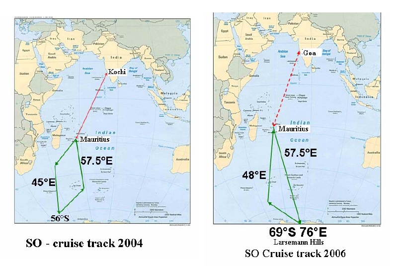
Cruises
The (Indian) National Centre for Antarctic and Oceanic Research (NCOAR)
http://www.ncaor.gov.in/ shows the following cruise tracks for 2004-2006. The objectives
and work plan for 2008-2009 are on the same website, and will cover the same geographical
area.
41
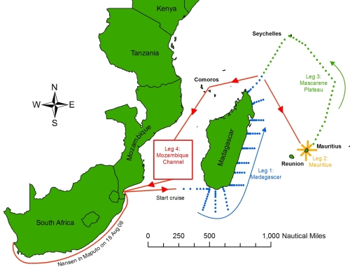
Cruises
7.1 Wio-LaB
-
7.2 ASCLME
Ten WIO-wide cruises will take place in collaboration with the EAF Nansen Programme, SWIOFP
and ACEP. The first four have taken place on an extended 100-day expedition from August to
December 2008.
ASCLME cruises - 2008
42
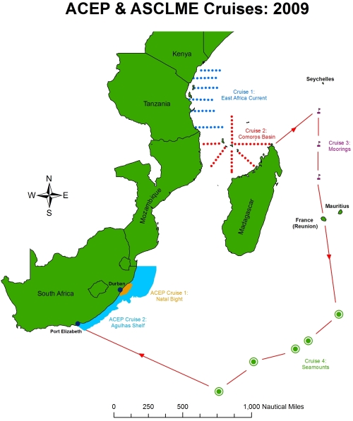
Cruises
Schematic of proposed ACEP and ASCLME cruises - 2009
7.3 Nairobi Convention Clearinghouse Mechanism
-
7.4 ODINAFRICA
-
7.5 ReCoMaP
-
7.6 RAMP-COI
-
7.7 AMESD
-
7.8 SWIOFP
-
7.9 COAST-MAP-IO
-
7.10 WIO Cetacean Conservation and Research
43
Cruises
In the frame of the WIO cetacean Conservation & Research project, a student participated in the cruise
from Mauritius to Seychelles, in order to observe the cetacean over the "Mascareignes Plateau". The
travels cost to Mauritius and from Seychelles for the student were supported by the IOC.
7.11 TRANSMAP
-
7.12 Marine Highway Project
-
7.13 WIOFish
-
7.14 Long-Term Ocean Climate Observations - LOCO array
Cruises will take place in early 2009 and 2010. Funding has been secured till 2012.
7.15 UNESCO/IOC and the Capacity Development Programme in the WIO region
Data FROM cruises? To validate models?
7.16 IUCN
7.26 MESOBIO
Previous cruises (ACEP 2007, ASCLME / NANSEN Leg4 2008) may be considered as pre-
MESOBIO cruises as results from these cruises will be analysed in the course of MESOBIO together
with new data to come, and because the sampling methodology based on the near-real time eddy
monitoring will be used during MESOBIO cruises.
New cruises will be achieved during the project:
MESOP 2009 (10/24/09 to 11/10/09, onboard the IRD R/V ANTEA)
MESOP 2010 (proposal for a cruise in April 2010, to be validated in the course of 2009)
ACEP (R/V Algoa) or ASCLME (R/V Nansen) in 2010 : to be validated in 2009
ACEP (R/V Algoa) or ASCLME (R/V Nansen) in 2011 : to be validated in 2010
Other IRD / EME: Cruises
Another IRD / EME cruise has been applied for the ANTEA proposal 2010 (MICROTON). It should
consist of: 1) a transect between Réunion and Seychelles, and 2): northward transect from Seychelles
to 5°N. This cruise should be coupled to SWIOFP field study.
7.27 Thermocline Ridge of the Indian Ocean (TRIO)
Abstract copied verbatim, with permission, from the TRIO science plan:
A shallow thermocline, in conjunction with high sea surface temperature, results in strong air-sea
interactions between 5°S and 12°S in the Indian Ocean. This region is at the same time a cyclogenesis
region (with cyclones that can hit La Réunion or Madagascar), the genesis region of the Madden
Julian Oscillation (MJO, the main mode of intra-seasonal atmospheric variability) and hosts strong
interannual variability of the oceanic heat content. The TRIO project focuses on air-sea interactions at
those three timescales. One particular question is whether considering the oceanic response is
necessary to better understand (and forecast) tropical cyclones or MJO events?
TRIO will cruise from Indonesia to Seychelles, with two specific phases. First, an observing system of
the regions of strong MJO oceanic signature (North-Western Australian Basin, 5-12°S band) will be
installed, in conjunction with the RAMA mooring project and Argo, and by repeating partially a
44

Cruises
section already occupied by WOCE in late 1995-1996. The second leg will involve a close
collaboration with the SWICE project (Cyclone-targeted experiment) and will allow studying both
oceanic and atmospheric processes in the genesis region of MJO and many cyclones. In contrast with
Cirene, this approach will allow a basin scale study of the MJO. The variety of oceanic and
atmospheric variability along the TRIO cruise will also allow secondary science targets, and a close
links with 3 satellite projects (AltiKa, Megha Tropiques, SMOS). The CLIVAR Indian Ocean and
Asian-Australian Monsoon panels have endorsed the TRIO project.
7.29 Agulhas Current Transport
Three two-week cruises, eighteen months apart are planned, with the first deployment cruise
tentatively scheduled for March 2010. Seven full-depth moorings will be deployed, each with single-
point Doppler current meters at depths throughout the water column, topped with upward-looking,
profiling Doppler current meters at 350 m below the surface.
45
Cruises
Past cruises (2004-2007) as presented by Hermes et al. at the ASCLME Regional Forum.
PI / Contact
Project / Website
Description
Status
Data
J Vialard
CIRENE cruise on Atalante
Port of dep/end: Victoria
Scheduled 5th
-
(Seychelles), Jan - Feb 2007 January-21st
LOCEAN, France
Aim: to study air-sea
February 2007
interaction at intraseasonal
timescale.
Comment: an ATLAS
mooring will be deployed
during the cruise and left for
~1 1/2 year after that.
K Yoneyama
MISMO cruise on MIRAI
Updated cruise details
Approved -
Y Kuroda
Aim: to study the onset of
MJO convection in the Indian
Ocean. Additional
observations are possible.
JAMSTEC, Japan
Weidong Yu
Antarctic Routine Cruise on
Port of dep/end: Shanghai
Approved and
-
R/V Xue-Long
(China), November 2005 -
ongoing
April 2006
FIO/SOA, China
Call at: Willington (New
Zealand); Great Wall and
Zhong Shan Stations
(Antarctic); Fremental
(Australia)
Weijia Qin
Comment: A subsurface
ADCP mooring off Java is
planned with cooperation
with Australia and US. This
deployment is scheduled at
the return leg in early 2006.
HD XBT section between
15S-15N will be done. Drifter
deployment along the route
is possible if there are drifter
suppliers.
PRIC, China
Weidong Yu
Ocean-1 Global Survey on
Port of dep/end: Qingdao
Approved and
-
Ocean-1
(China), 2 April 05 Jan 06
ongoing
FIO/SOA, China
Call at: Ponape (Micronesia);
Mexico; Cape Town (S Africa)
and Singapore (track vs.
Indian Ocean mooring and
XBT network)
Ning Zhou
Comment: Deployment of
three moorings for
PMEL/NOAA is schedule
during its passing by
(cooperation between
FIO/SOA and PMEL/NOAA).
A XBT section is conducted
acrossing the north Pacific.
Further XBT and drifter
chances are available.
46
Cruises
V S N Murty
ORV Sagar Kanya cruises
1st cruise: 15 May - 15
Proposed to DOD,
-
June 2005, along 77E and
India (plan for 2006
83E between 5N and 5S
underway)
NIO, India
Aim: hydrographic
survey/multi-disciplinary
observations
2nd cruise: November
2005, along equtorial zone
between 77E and 93E
Aim: Indian and TAO
moorings service
Comment: ship time for
additional relevant tasks is
possible
R Molcard, LOCEAN,
INSTANT 2nd phase
INSTANT: International
The 2nd phase
-
France; I Soesilo, JT
Nusantara STratification
begins in June 2005
Anggadiredja, J
ANd Transport
Sopaheluwakan (BRKP,
BPPT, LIPI) Indonesia
Aim: to investigate the
Indonesian Throughflow
(ITF), which links the Pacific
and Indian oceans.
Comment: the observing
arrays will be recovered and
redeployed for another 18
months period.
G Quartly
MadEx cruise on RRS
Port of dep/end: Durban
Likely recovery /
-
Discovery
(South Africa), 26 Jan - 21
servicing is Feb.
Feb 2005
2006, supported by
NERC, UK
NOC, UK
Aim: to investigate the
current to the south of
Madagsascar, which may
contain contributions from
the East Madagascar
Current (EMC), eddies and a
supposed 'retroflection'.
Comment: 4 moorings
deployed, CTD, SeaSoar
and underway
measurements
47
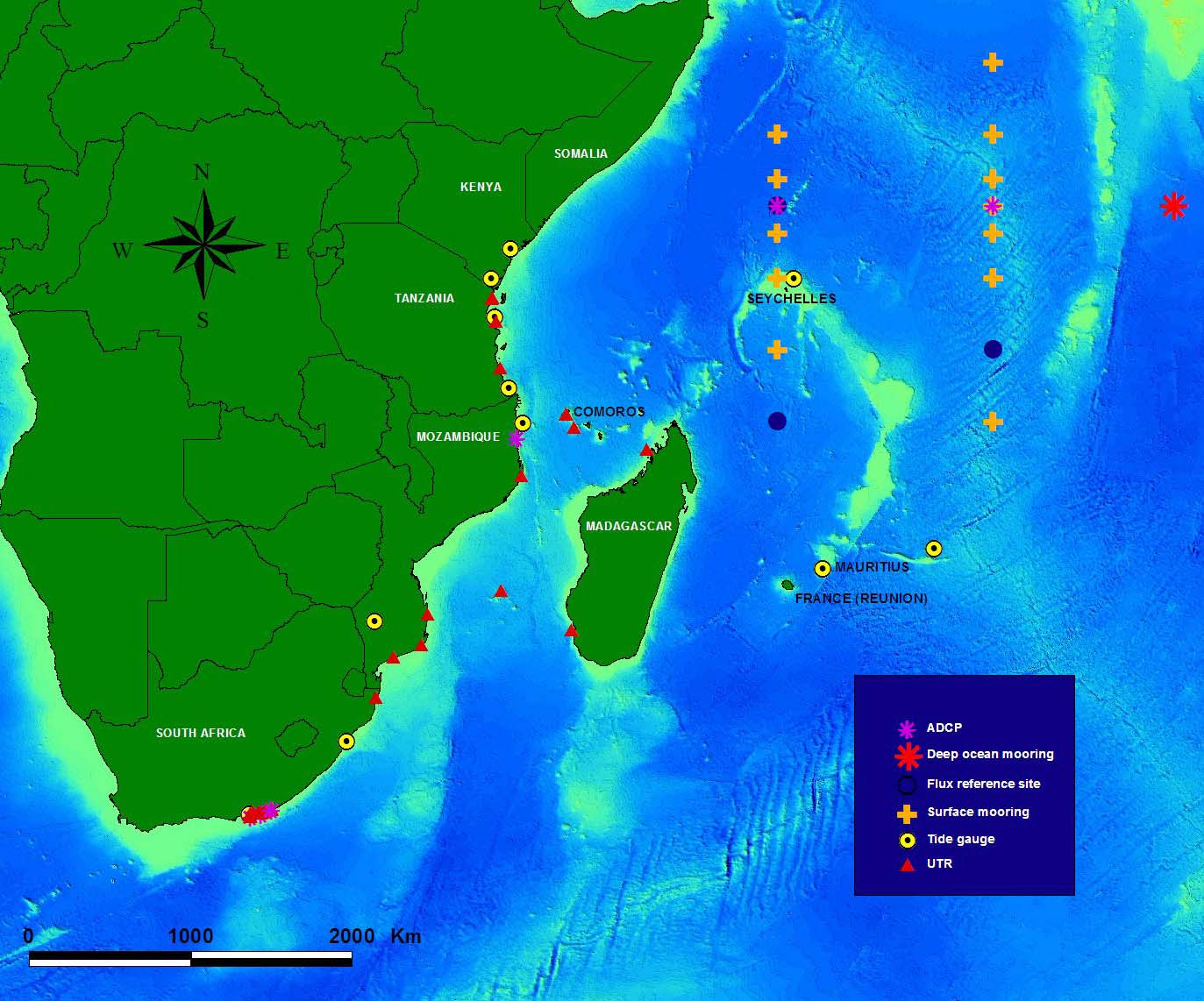
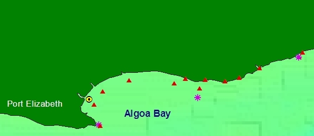
Remote Sensing
8. IN-SITU INSTRUMENTATION
LOCO array
In-situ Instrumentation for the measurement of oceanographic/atmospheric variables in the
Western Indian Ocean Region (as of November 2008)
48
Remote Sensing
8.1 Wio-Lab
-
8.2 ASCLME
The ASCLME Project has worked with NOAA, BCRE, ACEP, Norway and Mozambique for the
deployment of Atlas moorings (as part of the RAMA array), Argo floats, surface drifters and a
mooring off Pemba, Mozambique.
8.3 Nairobi Convention Clearinghouse Mechanism
-
8.4 ODINAFRICA
Tide gauges have been installed or upgraded at the following locations through the joint efforts of
various initiatives of UNESCO/IOC such as ODINAFRICA, the Global Sea Level Observing System
(GLOSS) and the Indian Ocean Tsunami Early Warning and Mitigation System (IOTWS). These
include:
Station
Latitude (S)
Longitude (E)
Kenya Mombasa
4.07
o
39.65 o
Lamu
2.28
o 40.90 o
Madagascar
Nosy Be
PLANNED not yet scheduled
Mauritius Port
Louis 20.15 o
57.50 o
Rodrigues
19.67 o
63.42 o
Mozambqiue Inhambane 23.87
o 32.37
o
Pemba
12.97 o
40.50 o
Seychelles Pt.
Larue 4.67 o
55.53 o
Tanzania Zanzibar 6.15 o
39.18 o
Mtwara
PLANNED
2008
8.5 ReCoMap
-
8.6 RAMP-COI
-
8.7 AMESD
-
8.8 SWIOFP
-
8.9 COAST-MAP-IO
-
8.10 WIO Cetacean Conservation and Research
-
8.11 TRANSMAP
-
8.12 Marine Highway Project
49
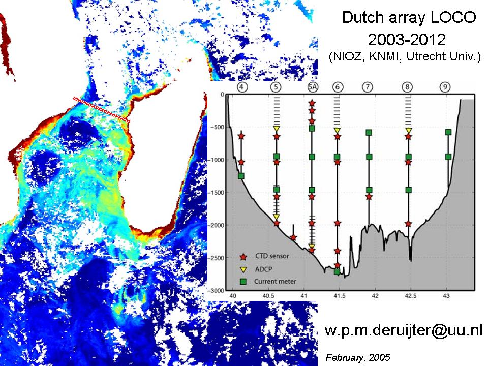
Remote Sensing
-
8.13 WIOFish
-
8.14 Long-Term Ocean Climate Observations - LOCO array
An array of moorings (the LOCO program) is maintained till at least 2012 across the narrow section of
the Mozambique Channel. LOCO has hydrographic cruises to study the currents and eddies in this
region.
8.15 IOC CD
-
8.16 IUCN
-
8.17 ACEP
Underwater temperature deployment positions identified during ACEP Phase I:
Mozambqiue Xai
Xai
-25.1646 33.678117
Mozambqiue Ponta
Zavora
-24.482183 35.2391
Mozambqiue Zambia
Reef
-22.771333 35.584
Mozambqiue Mozambique
Island
-15.0645 40.785
50
Remote Sensing
Tanzania Songa
Mnara
-9.054483
39.61015
Tanzania Zanzibar,
Kibela
-6.4724 39.396767
Comoros Grande
Comore
-11.667533
43.263533
Comoros Moheli
-12.391567
43.739033
Madagascar Nosy
Iranja
-13.593033 47.784433
Madagascar Nosy
Ve
-23.655183 43.5858
France Bassis
da
India
-21.43845
39.67065
South Africa 9 Mile UTR
-27.414917 32.726667
Comoros
Itsandra UTR shallow
-11.667733 43.263066
Comoros
Mouillage de Moroni (Grand Comoro
-11.667533 43.263533
Comoros Itsandra,
Grande
Comore
-11.667533
43.263533
Tanzania Tanga
-5.2343 39.13234
Tanzania Tanga
-5.156 39.1672
ACEP Phase II:
ACEP funded and collaborative research in South African waters. Insert A shows the Algoa Bay core
study area of SAEON (Elwandle and Egagasini Node). Insert B shows the study area of ACEP's Natal
Bight Ecosystem project.
8.18 PUMPSEA
-
51
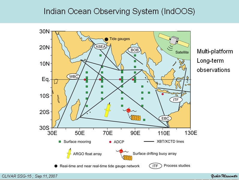
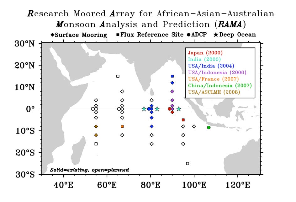
Remote Sensing
8.19 RAMA
Schematic of RAMA as of December 2008. From McPhaden et al.
http://www.pmel.noaa.gov/tao/doc/RAMA_BAMS2608_final.pdf
Details about RAMA sensors:
http://www.clivar.org/organization/aamp/documents/E_Supplement_RAMA_BAMS2608.pdf
8.20 Indian Ocean Observing System (IndOOS)
52
Remote Sensing
The IndOOS website (http://www.incois.gov.in/Incois/iogoos/insitu_mooring.jsp) provides
the following links:
NOAA/PMEL data are available at the TAO/TRITON web site:
http://www.pmel.noaa.gov/tao/disdel/
JAMSTEC data are available at their website:
http://www.jamstec.go.jp/jamstec/TRITON/real_time/index.html
NIOT/ NDBP data ate available at NDBP website:
http://www.niot.res.in/ndbp/ndbp/BuoyHome.php
The NIO equatorial mooring data are available at:
http://www.nio.org/data_info/deep-sea_mooring/oos-deep-sea-currentmeter-moorings.htm
The APDRC serves WOCE mooring data via an EPIC server at:
http://apdrc.soest.hawaii.edu/
The primary site for NOAA data is currently in transition. The OceanSites project is
developing a virtual data network for distribution of their data.
8.21 The Argo Programme
The Argo programme (www.argo.net) in the Indian Ocean
http://www.incois.gov.in/Incois/iogoos/argofloats.jsp
53
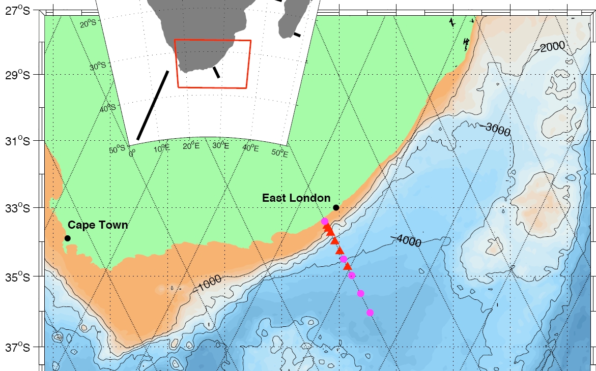
Remote Sensing
8.22 CLIVAR
-
8.26 MESOBIO
MESOBIO won't deploy in-situ instrumentation by itself. MESOBIO cruises might be,
however be used for servicing the ACEP UTR within the Mozambique Channel.
8.29 Agulhas Current Transport (ACT)
The project will deploy a three-year mooring array across the Agulhas Current off South Africa at
nominally 34S to measure its volume transport. The mooring array will be positioned offshore and a
little south of East London, where it will leave the African shelf at 33.4 S and follow the trajectory of
descending TOPEX/Jason ground track #96. These three years of in situ data will build towards long-
term monitoring capability of the Agulhas Current through correlations with sea surface height
fluctuations along the mooring line from satellite altimeter.
54
Remote Sensing
9. REMOTE SENSING and GIS activities
TRIO
GOOS Africa pilot projects (ChloroGin etc)
Alticore Africa
AMESD
ACCESS
ACEP/BCRE
IRD projects
Transmap
others
9.2 ASCLME
Marine Ecosystem Diagnostic Analyses (MEDAs)
Each ASCLME country will be working on a national MEDA during 2009 which will include reviews
of LME-relevant information and key spatial data sets. The MEDAs will include (in the annexes)
recommendations from the countries on requirements for GIS data collection as well as capacity
building and training. The information synthesised in the body of the MEDAs will be used to carry out
causal chain analyses for each country which will then inform the TDA. The data sets identified
during the MEDA process will be described (if not already described) and entered into a metdatabase
in 2009, later to be accessed in the development of national ecosystem atlases or similar, as well as the
development of specific information products (2010 and beyond).
9.26 MESOBIO
MESOBIO uses near-real time satellite data to locate precisely the mesoscale eddies during the course
of the cruises. Remote sensing data used are SLA (sea level anomaly), ocean color (SeaWiFS and
MODIS) and SST (NOAA AVHRR, TMI). Internet connection is used to receive the data from shore
based laboratory (French laboratories at Sčte and Brest, UCT laboratory).
55
Training
10. TRAINING
10.1 Wio-LaB
Training programmes so far supported focused on:
· General Marine Management Governance
· Leadership skills development for heads of Institutions
· Mainstreaming of coastal and marine issues in national policies and budgetary processes
· Water and sediment quality sampling and analysis (organics, metals, nutrients)
· Municipal wastewater management
· Legal aspects of LBSA Management
· TDA and SAP development
10.2 ASCLME
Institutional, programme and human capacity building requirements will be identified and addressed
through training initiatives. Participating countries will identify training requirements in the following
broad thematic areas among others:
· Strengthening of artisanal fisheries management
· MCS
· Oceanographic research theoretical and technical training
· Monitoring of the coastal and marine ecosystem
10.3 Nairobi Convention Clearinghouse Mechanism
· GIS (mapping, database development and population, modelling, web mapping)
· Remote sensing
10.4 ODINAFRICA
· modelling,
· GIS applications,
· remote sensing,
· data management,
· information (library) management,
· tidal predictions,
· websites development.
10.5 ReCoMaP
ReCoMaP has a fairly broad mandate for training activities under its Result Area 2 (see above).
During the programme's first 18-months support has been provided for participants to attend the
following training-related events:
· Ocean Colour Remote Sensing (2007);
· NFP and ReCoMaP ICZM Officer Study Tour to the CHARM Programme (Thailand, 2007);
· Participants to 5th WIOMSA Scientific Symposium (Durban, 2007);
· Integrating Social and Ecological Data Workshop (Mauritius, 2008);
· Coral-reef monitoring (COREMO 3) Database (Mauritius, 2008);
· ReCoMaP Regional ICZM Short-Course (Mauritius, 2008).
During the next 12-months or so training support will focus on support to WIOMSA COMPASS MPA
Certification (2008), support for a small-number of students to attend IMS's new MSc in Marine
Sciences. Furthermore, follow-up national-level ICZM short-courses will also be held. ReCoMaP is
also providing a small-grant to assist the Seychelles Maritime Training Centre's Advanced Fisheries
Science Certificate.
56
Training
In addition to programme-related training, our local-support team employed at the Regional
Coordinating Unit based in Mauritius have regular opportunities to benefit from attending training
courses to improve their capacities to support ReCoMaP's implementation, including courses in
Project Cycle Management and IT.
10.6 RAMP-COI
MPA managers Workshop (Antsiranana, Madagascar May 2008): information and discussion process
on sustainable financial mechanisms for MPAs and income generating revenues for local
communities. A Guide-type of report was produced for MPA managers compiling MPA information
in the region and factsheet related to different potential donors.
MPAs managers training on MPA management and effectiveness assessments (to be organised in
collaboration with Recomap).
10.7 AMESD
Training sessions (individual or collective) on:
· Spatial oceanography
· Analysis and the processing of satellite data: ocean color, altimetry ...
· Oceanic parameters /marines resources links and the use of spatial data
· for fishing
· Utilization of Eumetcast products and stations
· Digital modelling
· Utilization of AMESD products and services
10.8 SWIOFP
-
10.9 COAST-MAP-IO
Phase I:
· Training of agencies responsible for Disaster Management and Preparedness to create a series
of provisional maps that aid preliminary risk analyses and identify areas that need special
surveys
Phase II:
· Training in operating coastal engineering models and Graphical User interfaces for effective
presentations to decision makers
· GIS training for data mapping and as management tools in Disaster Management and
Preparedness
· Training in Integrated Coastal Area Management using integrated data sets and results from
numerical models
February 2009 report states that "At present six training courses were successfully conducted
by the National Hydrographic School of Indian Navy, Goa, India, the Training and Education
Centre in Hydrography at Alfred Wegener Institute for Polar and Marine Research, Germany,
the International Coordination Group for the Indian Ocean Tsunami Warning System in
Jakarta, Indonesia and Indian National Centre for Ocean Information Service(INCOIS)
Hyderabad, India. Modern hardware and software for modelling have been supplied to all
twelve countries. More than 75 specialists were trained."
10.10 WIO Cetacean Conservation and Research
-
10.11 TRANSMAP
-
57
Training
10.12 Marine Highway project
Training will be provided in areas deemed to enhance capacity building for hydrographic surveys, Oil
spill Contingency Planning, Environmentally Sensitive Areas and Ecosystem Valuation.
10.13 WIOFish
-
10.14 Long-Term Ocean Climate Observations LOCO
-
10.15 UNESCO/IOC and the Capacity Development Programme in the WIO region
a) Strengthening institutional structures
Training is core to the Capacity Development programme and presents the greatest opportunity for
collaboration between the programme and other projects in the region. The first phase of the
programme focuses on strengthening scientific, legal and institutional structures. The activities where
collaboration is already underway and can be strengthened include training for marine and coastal
institutes and management authorities in:
· Leadership and institutional development
· Proposal writing
· Team building
· Development of tools to support decision making (DSTs), namely technical training in
hydrodynamic modelling.
b) Raising awareness of decision makers and communities
The second phase of the programme will focuses on raising awareness of decision makers and
communities. This presents an opportunity to jointly plan support for capacity development of
institutes participating in one or more of the regional projects. Many collaborating institutes will be
involved in collecting and analyzing data, and developing products for regional projects. Potential
areas for collaboration include capacity development and training in:
· Scientific tools for decision making such as Hydrodynamic modelling; GIS; and Remote
Sensing
· Communication of science to stakeholders and the media
c) Pilot sites in DSTs hydrodynamic modelling
A number of pilot projects have been initiated through the trainings undertaken in hydrodynamic
modelling, and spin off projects. Collaboration on further development/transfer of the skills and
project outcomes may be possible with the national components of other regional project. Example
sites include the following where hydrodynamic models are under development:
· Kenya Mombasa harbour
· Mozambique Maputo harbour
· Mozambique - Pemba near shore
· Seychelles Victoria near shore
· Tanzania Zanzibar Channel
· Tanzania - Zanzibar shoreline change
· Tanzania Dar es Salaam harbour
Further sites and project information should be available shortly.
10.16 IUCN
-
58
Training
10.26 MESOBIO
Training component of the project will be:
during the cruises, with the participation of at least 2 trainees on each cruise
a summer course will be organised at the Université de la Réunion (july 2010) on the
"Relationships between environment and living resources, in the context of the SWIO and the
Mozambique Channel" (10 participants from outside La Réunion)
59
Regional assessments
11. REGIONAL ASSESSMENTS
11.1 Wio-LaB
· Transboundary Diagnostic Analysis of problems related to impacts from Land-based Sources and
Activities on the coastal and marine environment
· Regional Assessment of the Status of Pollution of Coastal Waters and Sediments
· Regional Assessment of the Status of Municipal Wastewater Management
· Regional Assessment of the Status of Physical Alteration and Destruction of Habitats
· Regional Assessment of River-Coast Interactions
· Regional Assessment of Existing Policy, Legal and Institutional Frameworks for Land-based
Sources and Activities Management
· Regional Assessment of the Status of Ratification of International Conventions related to Land-
based Sources and Activities Management
· Regional Assessment of National Policy and Institutional Framework for Environmental
Assessment
· Regional Training Needs Assessment related to Land-based Sources and Activities Management
· Regional Educational Needs Assessment related to Land-based Sources and Activities
· Regional Assessment of National Capacities for Monitoring Water and Sediment Quality and
Coastal and Marine Waters
11.2 ASCLME
· Meetings and a workshop have been held in each country for the establishment of a Technical
Coordination Group (COG)
· A Regional Meeting of Technical Coordination Groups has been held
· A Regional Forum for marine-related projects in the WIO has been held
· A regional meeting of D&I coordinators has been held.
· A regional review of projects in the WIO has been undertaken (this document)
11.3 Nairobi Convention Clearinghouse Mechanism
· 9-11 May 2006 Regional Clearinghouse Workshop, Nairobi.
http://www.wiolab.org/publications/copy_of_Meeting%20Reports
· Information management strategy for the development of the Nairobi Convention
Clearinghouse and information system.
http://www.wiolab.org/publications/Technical%20Reports
11.4 ODINAFRICA
Assessment of capacities (staff), assessment of internet connectivity, assessment of facilities and
infrastructure in NODCs, assessment of data and information needs for ICAM
11.5 ReCoMaP
· Regional GIS Assessment Report (July 2007);
· Regional Coastal Mariculture Assessment Report (October 2007);
· Review of the IOC Coral Reef Monitoring Network (November 2007);
· Sustainable Development of Coastal Tourism in the SWIO (November 2007):
o Potential & Feasibilities of National & Local Development of Coastal Ecotourism;
o Strategic Environmental Assessments at National and Regional Levels.
· Regional Review of Coastal Solid-Waste Management Arrangements (May 2008);
· Feasibility of Establishing a Cetacean & Dugong Network in the WIO (in prep.).
60
Regional assessments
11.6 RAMP-COI
Available reports: "General review of the biological, ecological, socio-economic, political, legal and
institutional aspects for Seychelles, Mauritius, Madagascar and Comoros". Evaluation / Assessment
of the Moheli marine park (2007).
11.7 AMESD
A Thematic Action (THEMA) "Marine and coastal management" proposed for the Indian Ocean zone,
resulting from a consultation process and evaluation of needs in the IOC region, covers needs
expressed by the institutions in charge of fish monitoring and fisheries resources in IOC countries for:
· Tools to improve the management efficiency and fish monitoring (against illegal fishing)
· Data and/or software tools useful for evaluation of stocks and pelagic catch.
· Data and tools enabling the analysis of variations of oceanic parameters and their
consequences on these resources.
· Means to improve the dissemination of data (particularly marine meteorology) to fisher
communities
11.8 SWIOFP
The outputs of the SWIOFP data management plan comprise the following:
· An analysis at national and then at a regional level of data relevant to the project assessment
components and the countries that will participate in them to identify specific gaps in existing
knowledge that would allow the participants in each component to identify detailed data collection
programs
· A workshop consisting of all SWIOFP countries at which a conceptual, harmonized, baseline data
collection program and data sharing protocols will be established to enable regional evaluation of
the harmonized, ecosystem-based management of fisheries resources
· An analysis at national and then at a regional level of data relevant to components in which each
country will participate and identification of specific gaps in existing data that would collectively
form the gap analysis used to identify the data collection program
· A workshop consisting of all SWIOFP countries at which a conceptual, harmonized, data gap
analysis (by type of fishery, i.e. demersal, pelagic, invertebrate) will be undertaken leading to
synthesis of a year-by-year data collection program
11.9 COAST-MAP-IO
Phase I:
· Assessment missions in participating countries to determine level of capacity, focal points and
national partner agencies and existing data sources
· IOC/IHO meeting to develop Work Programs (WP) and submission to National Agencies
· Review by National Agencies of WP components, identification of counterpart contributions,
and determination of local capacities to assume the tasks and responsibilities indicated in the
project
· Evaluation of national agencies responses by IOC/IHO, followed by official project launch
with all coordinating agencies. In the first part of this event the WP will be endorsed with
agreed on responsibilities and timetable. The second part will be a training course on data
capture, processing and management
· Identification of most vulnerable national coastal areas, collection of relevant coastal
bathymetry and coastal topographic data (surveys as needed) and collation of ancillary
information for at least one pilot project area in each country
Phase II:
· Workshops on coastal models incorporating integrated data sets to fine tune maps and
products for coastal communities at-risk
61
Regional assessments
· Workshops on the use of model and other information as Decision Support tools in integrated
coastal area management
· Seminar for exchange of experience and reinforcement of a regional approach to face common
problems. Identification of follow-up regional initiatives.
· IOC/IHO evaluation meeting of the project and report
See "COAST-MAP-IO Project: Building coastal resilience to ocean-based extreme events through
improved coastal mapping capacity in the Indian Ocean" Assessment Missions
11.10 WIO Cetacean Conservation and Research
Workshop for the research and conservation of cetaceans and the dugong in the IOC countries:
The Indian Ocean Commission organized a workshop in Sainte-Marie (Madagascar) from the 1st to the
4th of July 2007, tasked with:
· Assessing the situation in the Western Indian Ocean region
· Proposing a network for information exchange on cetaceans and the dugong
· Designing an IOC regional project
Workshop in Seychelles the 25 & 26 of November 2008 to:
Finalize and validate the cetacean Conservation & Research project proposal
Present the results of the feasibility study of a IOC cetacean network
11.11 TRANSMAP
Assessment of legal, institutional and policy frameworks (WP8). Since the begging of the project, the
team has been able to:
· Collect and synthesize into standardized tables the relevant instruments to be considered in the
report. This involved 6 types of tables, all available at the metadata base: global instruments;
regional instruments; ratification of global instruments; ratification of regional instruments;
Mozambican national legislation; South African national legislation; Tanzanian national
legislation.
· Initiate the analysis of the instruments and associated documentation;
· Produce drafts of report sections, now consolidated into a single document;
· Build organograms for each of the three countries depicting the institutions and their roles in
the MPA creation-to-management process;
· Envision a possible series of options for transboundary MPAs in the region that represent
different degrees of political commitment between the three African countries.
Assessment of the state of management in support of MPAs (WP9), while identifying sectoralisation
issues and need for multi-plan harmonization in the three countries. Since the begging of the project,
the WP9 team has been able to:
· Collect and synthesize into standardized tables the relevant instruments to be considered in the
report. This involved 4 types of tables, all available at the metadata base: multilateral
management instruments; Mozambican management instruments; South African management
instruments; Tanzanian management instruments.
· Initiate the analysis of the instruments and associated documentation;
· Produce drafts of report sections*;
· Build organograms for each of the three countries depicting the institutions and their roles in
the MPA creation-to-management process*.
11.12 Marine Highway Project
Assessment of risk and Impact Assessment from accidental oil spills in the zone.
62
Regional assessments
11.13 WIOFish
-
11.14 Long-Term Ocean Climate Observations LOCO
-
11.15 UNESCO/IOC and the Capacity Development Programme in the WIO region
IOC has undertaken a number of assessments relevant to planning regional collaborations, particularly
regarding capacity development:
· Marine Action Planning Document on institute priorities in the region
(http://ioc.unesco.org/tema/ZanzibarWorkshop.htm)
· Marine Science Country Profiles for countries in the Western Indian Ocean (WIOMSA/IOC -
Available on request or at ocean docs e.g. Kenya: http://hdl.handle.net/1834/124)
· National assessments of institutional capacity in marine science (available on request for some
countries of the WIO region)
· Guidelines for assessment of capacity development relevant to the region (http://www.ioc-
cd.org/index.php?option=com_content&task=view&id=40&Itemid=50).
11.16 IUCN EASARO recent reports
· Tanga several studies, recent review Wells, S, Makoloweka, S, and Samoilys M.
(eds.) (2007a). Putting Adaptive Management Into Practice: Collaborative Coastal
Management in Tanga, northern Tanzania. IUCN Eastern Africa Regional Office, x +197pp.
· MBREMP 13 technical studies
· Jakarta Mandate MPA toolkit, MPA Workbook (see e.g. WIOMSA website)
· Recent outputs:
· IUCN 2008. Building capacity for coastal communities to manage marine resources in
Kenya 5 Community Policy Advisories on priority issues. IUCN ESARO 2008.
· IUCN 2008. Building capacity for coastal communities to manage marine resources in
Tanzania 5 Community Policy Advisories on priority issues. IUCN ESARO 2008.
· Mirera H.O.D. and Samoilys M.A. 2008. Mariculture Exchange. Community visits
between Kenya and Tanzania. IUCN ESARO 2008.
· Samoilys M.A. and Kanyange N.W. 2008. Natural resource dependence, livelihoods and
development: Perceptions from Kiunga, Kenya. IUCN ESARO 2008.
· Samoilys M.A. and Kanyange N.W. 2008. Natural resource dependence, livelihoods and
development: Perceptions from Tanga, Tanzania. IUCN ESARO 2008.
11.26 MESOBIO
Meetings will be organized in the course of the project. One of them will hold in the framework of the
WIOMSA meeting (August 2009) and will be dedicated more specifically to mesoscale eddies in the
Mozambique Channel.
63
Project duration
12. PROJECT DURATION
2004 2005 2006 2007 2008 2009 2010 2011 2012 2013
Wio-LaB
ASCLME
NC-CHM
>>
ODINAFRICA
III
IV
ReCoMaP
* * * * * *
RAMP-COI
* * * * *
AMESD
SWIOFP
COAST-MAP-IO
* *
WIO Cetacean
Conservation and
Research
TRANSMAP
* * * *
Marine Highway *
*
*
*
Project
WIOFish
* * * * *
LOCO
* * * * * * * * *
IOC-CD
* * *
II* II* II* II*
IUCN
ACEP
Pumpsea
RAMA
IndOOS
Argo Programme
CLIVAR
GOOS Africa
Seamounts: EAF
Fisheries Project
MESOBIO: Project duration
MESOBIO is expected to be achieved from 2009 till 2011 (3 years programme, kick-off meeting
expected in June 2009)
IRD / EME: Project duration
MADE: 2008-2012
BIOPS: 2008-2010
64
List of Projects
Appendix I. List of regional institutions, programmes and projects in the WIO region
Table 1. Field list for the ASCLME Regional Projects database
1 Project ID
2 Project
name
3 Acronym
4 AOI
5 Participating
countries
6 Aim
7 Description
8 Project status (past/active/future/proposed)
9 Website/Contact
10 F&F
11 Prod.
12 Ecosys.
13 Socio.
14 Gov.
15 Climate
change
16 Equipment/Instrumentation
17 DM/GIS/RS
(y/n)
18 Details
19 CB/training
20 Ship/in-situ
21 Primary
products
22 Partners
23 Funder
24 Fund
recipients
25 Area of collaboration
26 Scale
27 Reports/papers
(y/n)
28 Comments
Table 2. The list of projects, programme, institutes and organisations in the ASCLME database
Project
ID
Project name
United Nations Educational, Scientific and Cultural Organization World
1 Heritage Centre
United Nations Educational, Scientific and Cultural Organization International
2 Oceans Commission
3 Global International Waters Assessment
4 The New Partnership for Africa's Development
5 The New Partnership for Africa's Development Coastal and Marine
6 AfriBasins Project
Development and Protection of the Coastal and Marine Environment in Sub-
7 Saharan Africa `The African Process'
8 Global Coral Reef Monitoring Network
Global Program of Action for the Protection of the Marine Environment from
9 Land-Based Activities
65
List of Projects
10 Ocean Data and Information Network for Africa
11 Global Climate Observing Centre
12 Global Ocean Observing System
13 International Coral Reef Initiative
14 World Conservation Monitoring Centre
15 International Coastal Atlas Network
16 ALTImetry in Coastal Regions
17 Moving Sushi Marine Resources Expedition
18 Ocean Tracking Network
19 Global Observing Systems Information Center
20 World Meteorological Organization
21 Development of an African Repository for Electronic Publications
22 Addressing Land-based Activities in the Western Indian Ocean
23 IUCN East & Southern Africa Regional Programme
24 Regional Tuna Tagging Project - Indian Ocean
25 Agulhas and Somali Current Large Marine Ecosystems Project
26 Western Indian Ocean Islands Oil Spill Contingency Planning
Regional Programme for the Sustainable Management of Coastal Zones of the
27 Countries in the Indian Ocean
West Indian Ocean Electronic Highway Development and Coastal and Marine
28 Contamination Prevention Project
Adaptation to Climate Change - Responding to Shoreline Change and its human
29 dimensions in West Africa through integrated coastal area management
30 Protection of the Canary Current Large Marine Ecosystem
31 Integrated management of the Benguela Current Large Marine Ecosystem
Wings Over Wetlands: Enhancing conservation of the critical network of sites
32 of wetlands required by migratory waterbirds on the African/Eurasian flyways
Combating living resources depletion and coastal area degradation in the Guinea
33 current Large Marine Ecosystem through ecosystem-based regional activity
34 Regional strategy for marine protected areas in West Africa (PRCM)
35 Regional Network of Marine Protected Areas in West Africa
Development and protection of the coastal and marine environment in sub-
36 Saharan Africa
37 Agulhas Somali Currents Large Marine Ecosystem Project
38 South West Indian Ocean Fisheries Programme
39 African Coelacanth Ecosystem Programme
40 Census of Marine Life
41 World Heritage Centre
42 Intergovernmental Oceanographic Commission
43 Coral Reef Degradation in the Indian Ocean
44 Reef
Watcher
45 reefcheck
46 reef
doctor
47 reefbase
48 fishwatch
49 group on earth observations
50 global earth observation system of systems
51 european space agency
52 Global Biodiversity Information Facility
53 United Nations Development Programme
54 World
Bank
55 Conservation
International
56 Food and Agricultural Organisation
66
List of Projects
57 FAO Fisheries and Aquaculture Fisheries Global Information System
58 FAO Committee on Fisheries
59 FAO COFI Sub-committee on fish trade
60 FAO COFI Sub-committee on aquaculture
FAO Fisheries and Aquaculture Department (Programme on Fisheries and
61 Aquaculture)
62 Wildlife Conservation Society
63 Global International Waters Assessment
64 Division of Early Warning and Assessment
65 Nairobi Convention
66 Nairobi Convention Clearing House Mechanism
67 Indian Ocean Commission
69 Geological Survey of Denmark and Greenland
70 Scripps Institution of Oceanography
71 Aquamarine
Fukushima
72 National Geographic Society
73 National Geographic Committee for Research and Exploration
74 The Nature Conservancy
75 Mazda Wildlife Fund
76 Value added ALTImetry in Coastal Regions
77 The ARGO project
78 Indian Ocean Tuna Commission
79 International
Maritime
Organisation
80 Plymouth Marine Lab
81 Joint Institute for Marine Observations
82 European Union
83 European Union Joint Research Council
84 UNEP Regional Seas Programme
85 South African Shark Conservancy
86 Natal
Sharks
Board
87 Oceanographic Research Institute
88 South African Marine Predator Labortary
89 World Wide Fund for Nature
90 Southern African Sustainable Seafood Initiative
91 WWF Responsible Fisheries Programme
92 Marine Stewardship Council
93 Ocean
Conservancy
94 Global Coral Reef Alliance
95 Blue Flag Programme
96 Ocean Futures Society
97 Shifting baselines: common sense for the ocean
98 International Center for Living Aquatic Resources Management
99 Marine Conservation Biology Institute
100 Planetary Coral Reef Foundation
101 International
Marinelife
Alliance
102 Whale and Dolphin Conservation Society
103 Africa Conservation Fund
104 UN Division for Ocean Affairs and Law of the Sea
105 United Nations Commission on Sustainable Development
106 Global Runoff Data Centre
107 The World Bank Fisheries and Aquaculture
108 International Council for the Exploration of the Seas
67
List of Projects
Joint Group of Experts on the Scientific Aspects of Marine Environmental
109 Protection
110 UN Convention on Biological Diversity
111 UN Convention on the Law of the Sea
112 International
Whaling
Commission
113 World Water Vision
114 International Centre for Living Aquatic Resources Management
115 International
Geosphere-Biosphere Project
116 World Resources Institute
117 WRI Global Marine Strategy
118 Worldwatch
Institute
119 Advisory Committee on Protection of the Sea
120 African Water Page
121 Clean Islands International, Inc.
122 Global Water Partnership
123 International Office for Water
124 International
Ocean
Institute
125 International Water Law Project
126 GEO Data Portal
127 GRID
Africa
GeoPortal
128 Prototype Environmental Assessment and Reporting Landscape
129 Plymouth Marine Lab Remote Sensing Group
130 WIO-rise
131 EAF
Nansen
Programme
132 Agulhas Current Transport
Marine Protected Areas Network of the Indian Ocean Commission Countries
133 (RAMP-COI)
134 African Monitoring of Environmental for Sustainable Development
Improving Emergency Response to Ocean-based Extreme Events through
135 Coastal Mapping Capacity Building in the Indian Ocean
136 WIO Cetacean Conservation and Research
Transboundary networks of marine protected areas for integrated conservation
and sustainable development: biophysical, socio-economic and governance
137 assessment in East Africa
138 WIOFISH
139 Long-Term Ocean Climate Observations
Peri-urban mangrove forests as filters and potential phytoremediators of
140 domestic sewage in East Africa
The Research Moored Array for African-Asian-Australian Monsoon Analysis
141 and Prediction
142 Indian Ocean Observing System
143 Argo
Programme
144 Climate Variability and Predictability
Applying an ecosystem-based approach to fisheries management: focus on
145 seamounts in the southern Indian Ocean
146 Western Indian Ocean Marine Science Association
Influence of mesoscale dynamics on biological productivity at multiple trophic
147 levels in the Mozambique Channel
148 Thermocline Ridge of the Indian Ocean
68
Document Outline
- ţ˙
- ţ˙
- ţ˙
- ţ˙
- ţ˙
- ţ˙
- ţ˙
- ţ˙
- ţ˙
- ţ˙
- ţ˙
- ţ˙
- ţ˙
- ţ˙
- ţ˙
- ţ˙
- ţ˙
- ţ˙